| |
Upper Mono Trail has only one trailhead, so you'll be trekking it in and back out. This wilderness hiking trail has a total elevation difference of 2,097 feet, and that is about average. Now, this is roughly a 2-day walk, so it's a fine thing if your backpack is big enough to do the job. This backcountry hiking trail sometimes gets very dry, so don’t forget to check for any current fire restrictions before you go. With its 12.8 miles of walking distance; it's longer than many great outdoors trails. Different parts of Upper Mono Trail are at very different elevations which of course means you need to be prepared for different conditions on different parts of the great outdoors trail. Upper Mono Trail is quite long, so make sure you bring plenty of supplies.
|
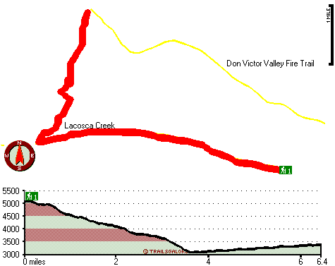
Total in and out hiking length = 12.8 miles
Total climbing distance = 4.9 miles
Difficulty : Difficult
Casual Hiking Pace:
2 days
Fast Hiking Pace:
7 hours
Total elevation difference: 2097 feet
|


