California hiking trails - Trappers Trail, Santa Cruz Mountains, San Mateo County

   
  Time to get out, and breathe some fresh air, and Trappers Trail in San Mateo County, California is a splendid place for getting out. Trappers Trail is positioned a pretty lengthy journey from San Jose-Sunnyvale-Santa Clara, but it is a really good great outdoors trail. Here in the good state of California trekking is a great idea. California has so much to offer the outdoors lovers. This is one of many great outdoors trails in the surrounding neighborhood. Summertime highs at Trappers Trail regularly tend to be in the 70's, and during summer nights temperatures
    are in the 50's. Highs during the wintertime are frequently in the 50's with winter lows in the 40's overnight here at Trappers Trail. It is very arid here at Trappers Trail commonly; January is the month that gets the most rain; July on the other hand is the driest. Each backpacking
trail in California is worth trekking. Trappers Trail is a two ended wilderness hiking trail with two trailheads, so backpacking it one way is an option if you can arrange for a ride back. California has plenty of good backpacking trails; Trappers Trail in San Mateo County is one of them. There's not much difference in elevation along Trappers Trail which means the conditions are about the same from start to finish. Trappers Trail is 4.6 miles long it's a mid length backcountry trek. The length of Trappers Trail is about average with an average amount of  
climbing distance which makes this great outdoors trail great for the average backcountry walker looking for a cool adventure. Hiking here in the Santa Cruz Mountains is a nice way to explore these peaks. And keep in mind that there could be temporary safety restrictions in place. This great outdoors hiking trail sometimes gets very dry, so make sure you check current conditions and fire restrictions with local forest authorities before you head out. Even though this is not a very long great outdoors hiking trail it's always brilliant to bring some emergency supplies, you never know what could happen. The total elevation difference for this wilderness hiking trail is 1,148 feet which is about average. The time needed for this backcountry trek is roughly 4 hours, but of course some folks walk a bit slower and some a bit faster.

Briefly about the general area:
There's so much to do here at Trappers Trail that you need to camp here for a while, Portola Redwoods State Park is a great place for that; why not have a look at nearby Damiani Creek since you're here at Trappers Trail. Coal Creek is a beautiful stream that is worth going to, and Trappers Trail is brilliant enough to spend more than a day at, Trailer Villa is a brilliant local campground.
You're sure to encounter some friendly people from San Jose-Sunnyvale-Santa Clara here. Life's too short to enjoy all the exciting things in the Santa Cruz Mountains. If you want a little side visit, try Rengstorff Gulch, and whitewater paddling is good on Pescadero Creek.

Location of Trailhead 1: Latitude 37.3454, Longitude -122.1779
- - Directions and Road Map

Location of Trailhead 2: Latitude 37.3605, Longitude -122.2017
- - Directions and Road Map


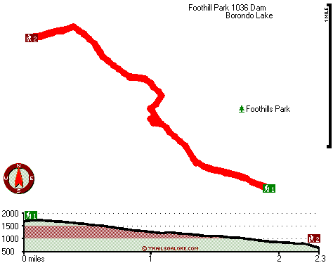
Trailhead 1 to Trailhead 2:
Total hiking length = 2.3 miles
Total climbing distance = .1 miles
Difficulty : Easy
Casual Hiking Pace: 1.5 hours
Fast Hiking Pace: 1 hours

Trailhead 2 to Trailhead 1:
Total hiking length = 2.3 miles
Total climbing distance = 1.8 miles
Difficulty : Difficult
Casual Hiking Pace: 2.5 hours
Fast Hiking Pace: 1.5 hours
    Trailhead 1 back to Trailhead 1:
Total hiking length = 4.6 miles
Total climbing distance = 1.9 miles
Difficulty : Medium
Casual Hiking Pace: 4 hours
Fast Hiking Pace: 2.5 hours

Trailhead 2 back to Trailhead 2:
Total hiking length = 4.6 miles
Total climbing distance = 1.9 miles
Difficulty : Medium
Casual Hiking Pace: 4 hours
Fast Hiking Pace: 2.5 hours

Total elevation difference: 1148 feet


National at Oak Creek Palo Alto, Palo Alto
4 miles away
Oak Creek is surrounded by 27 acres of beautiful oaks. Oak Creek offers many recreational options to enjoy such as lighted tennis courts-swimming pools-aerobic classes-media center / theater and mini ...
  
Stanford Terrace Inn, Palo Alto
5 miles away
Across the street from the Stanford campus, you will find the Stanford Terrace Inn, an oasis of unexpected elegance. In the midst of Silicon Valley, you will discover a tradition of old world hospita...
User input for Trappers Trail, Santa Cruz Mountains, San Mateo County, California:

Submit Input:
Your Name:
Write or Paste Input here:

Upload picture:      Review Guidelines


Outdoors Recreation Near San Jose-Sunnyvale-Santa Clara, California
Very comprehensive list of a variety of outdoors recreation in the vicinity of San Jose-Sunnyvale-Santa Clara, California, the metro area neareast to Trappers Trail. Find info on campgrounds, hiking trails, ski resorts, lakes, beaches, parks, whitewater and more.

Current weather conditions at Trappers Trail, Santa Cruz Mountains, San Mateo County, California
WXPort

Local climate location: SAN FRANCISCO WSO AP 2 miles away

Sheraton Palo Alto Hotel, Palo Alto
5 miles away
Set amidst picturesque water and flower gardens and koi ponds, the Sheraton Palo Alto Hotel is a source of familiar comfort in the Silicon Valley. Our resort-like setting welcomes with beautiful flowe...

The Westin Palo Alto, Palo Alto
5 miles away
Experience California at The Westin Palo Alto, adjacent to Stanford University, and within walking distance of some of the best restaurants, shops, and nightlife. Relax in one of our five Mediterranea...

More Hotels and Campgrounds Near Trappers Trail, Santa Cruz Mountains, San Mateo County, California

OTHER_INFO
  Santa Cruz Mountains Campgrounds
Complete list of all the campgrounds in the Santa Cruz Mountains.

Santa Cruz Mountains Outdoors Info
Complete outdoors info for the Santa Cruz Mountains.

California Hiking Trails
Complete list of all hiking trails in California

Books about hiking trails in California
List of books available on Amazon.com about hiking trails in California.

California Outdoors Index
This is a very comprehensive index of outdoors activities in the great state of California.


TOPO
High quality water resistant topo map of Trappers Trail, Santa Cruz Mountains, San Mateo County, California.

OUTDOORS_GUIDE
These outdoors activities are available near Trappers Trail.
 Trails Near Trappers Trail:
Summit Trail, San Mateo County , 6 miles away,  3 hiking miles, 506 feet elevation difference
Coyote Ridge Trail, San Mateo County , 6 miles away, 1.2 hiking miles, 549 feet elevation difference
Sequoia Nature Trail, San Mateo County , 6 miles away,  .4 hiking miles, 32 feet elevation difference
Alambique Trail, San Mateo County , 6 miles away,  6.4 hiking miles, 818 feet elevation difference
Butano Ridge Loop Trail, San Mateo County , 7 miles away,  4.2 hiking miles, 1656 feet elevation difference
Edgewood Trail, San Mateo County , 9 miles away, 1.2 hiking miles, 198 feet elevation difference
Ano Nuevo Trail, San Mateo County , 13 miles away,  3.2 hiking miles, 1082 feet elevation difference
 Camp Grounds Near Trappers Trail:
Portola Redwoods State Park, San Mateo, 5 miles away
Trailer Villa, Redwood City, 7 miles away
Trailer Rancho, Redwood City, 7 miles away
Huckleberry Campground, Santa Cruz County, 10 miles away
Wastahi Campground, Santa Cruz County, 10 miles away
 Whitewater Near Trappers Trail:
Pescadero Creek, San Mateo County County , 7 miles away, Class II - 9 miles long (Portola State Park to Memorial County Park)
 National Parks Near Trappers Trail:
Juan Bautista De Anza National Historic Trail, San Francisco - CA , 22 miles away
Golden Gate National Recreation Area, San Francisco - CA , 29 miles away
Presidio National Park, San Francisco - CA , 29 miles away
 Hotels Near Trappers Trail:
National at Oak Creek Palo Alto, Palo Alto , 4 miles away
Stanford Terrace Inn, Palo Alto , 5 miles away
Sheraton Palo Alto Hotel, Palo Alto , 5 miles away
The Westin Palo Alto, Palo Alto , 5 miles away
Super 8 Motel - Palo Alto/Stanford University Area, Palo Alto , 5 miles away
 Lakes Near Trappers Trail
Knuedler Lake, San Mateo County , 5 miles away
Bear Gulch Reservoir, San Mateo County , 5 miles away

Outdoors related information copyright © Stratus-Pikpuk, Inc. - Detailed hotel information copyright © Interactive Hotel Solutions