| |
|
| | A lengthy journey separates Bakersfield from Tobias Creek Trail, but it is a glorious hiking and backpacking trail. California is a tremendous site for hikers. Every backpacking trail in California has its own character. Keep in mind that this is a long backcountry trail, so don't forget to pack enough supplies. This backcountry trail sometimes gets very dry, so don’t forget to check for any current fire restrictions before you go. There are so many backcountry hiking trails in this vicinity. For the duration of the summertime months highs here at Tobias |
|
Creek Trail get into the 90's, and through the night it cools down to the 60's. The winter brings highs down to the 50's, and after the sun is down through the winter temperatures at Tobias Creek Trail plunge into the 30's. This walk should take you about 2 days, so it's a magnificent
| | thing if your backpack is big enough to do the job. Tobias Creek Trail gets a typical amount of annual rainfall; most of the rain falls throughout January while July is generally the driest month. With its 13 miles of walking distance; it's longer than many backcountry trails. This backcountry trail goes through some very different elevations which of course means you need to be prepared for different conditions on different parts of the backcountry trail. When you're here in California backcountry hiking along one of its backpacking trails is the nice | |
|
thing to do. Backpacking here in the Southern Sierra Nevada is a tremendous way to explore these mountains. And keep in mind that there could be temporary safety restrictions in site. This hiking trail has two trailheads, so if you can get a ride from someone, you can walk it just
one way. This hiking trail has a total elevation difference of 4,434 feet, and that is higher than average. Can’t wait to get out in the great outdoors, if you happen to be in Tulare County of California, Tobias Creek Trail is a glorious local hiking and backpacking trail for doing
a bit of leg stretching. This hiking trail is many miles long having an average number of uphill miles which makes this backcountry hiking trail delightful for hard core backpackers looking for adventure. There are backpacking trails all over California; one of them being Tobias
Creek Trail in Tulare County.
Briefly about the general area: Scarlet and Davis Canyon is a splendid site to stop at close by, and East Horse Meadow is a tremendous place to check out. Man, is there a heap of cool stuff to do in the Southern Sierra Nevada. Take some
time to visit Packsaddle Grove if you're here, and you can run the rapids of Kern River. There's so much to do here at Tobias Creek Trail that you need to camp here for a while, Lower Campground is a magnificent place for that, and Horse Meadow is a delightful spot any time
of year. You'll wish for more hours in a day to enjoy all the fun things at Tobias Creek Trail. If you came to camp Frog Meadows Campground is a nice site to do that, and Brush Creek is a great whitewater spot nearby. You clearly have to go for the Southern Sierra Nevada. Tobias
Creek is a magnificent place to visit; don't leave Tobias Creek Trail without first paying a visit to Thompson Camp Spring. Speas Creek is a glorious local stream, and the beauty of mother nature reveals herself at Lion Spring.
|
|
Location of Trailhead 1: Latitude 35.9229, Longitude -118.4993 - - Directions and Road Map
Location of Trailhead 2: Latitude 35.8738, Longitude -118.5745 - - Directions and Road Map

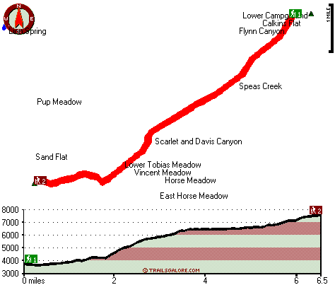
Trailhead 1 to Trailhead 2: Total hiking length = 6.5 miles Total climbing distance = 4.5 miles Difficulty : Difficult Casual Hiking Pace:
7 hours
Fast Hiking Pace:
4 hours
Trailhead 2 to Trailhead 1: Total hiking length = 6.5 miles Total climbing distance = .9 miles Difficulty : Difficult Casual Hiking Pace:
4.5 hours
Fast Hiking Pace:
2.5 hours
| | Trailhead 1 back to Trailhead 1: Total hiking length = 13 miles Total climbing distance = 5.4 miles Difficulty : Difficult Casual Hiking Pace:
2 days
Fast Hiking Pace:
7.5 hours
Trailhead 2 back to Trailhead 2: Total hiking length = 13 miles Total climbing distance = 5.4 miles Difficulty : Difficult Casual Hiking Pace:
2 days
Fast Hiking Pace:
7.5 hours
|
Total elevation difference: 4434 feet

Best Western Porterville Inn, Porterville
|
35 miles away
We are 100% Smoke-Free hotel with a warm and friendly staff that awaits you at the Best Western Porterville Inn. We offer a spacious, elegant lobby and a selection of tastefully decorated, handsomely ...
|
| |
|
User input for Tobias Creek Trail, Southern Sierra Nevada, Tulare County, California:

Outdoors Recreation Near Bakersfield, California Very comprehensive list of a variety of outdoors recreation in the vicinity of Bakersfield, California, the metro area neareast to Tobias Creek Trail. Find info on campgrounds, hiking trails, ski resorts, lakes, beaches, parks, whitewater and more.
|
Current weather conditions at Tobias Creek Trail, Southern Sierra Nevada, Tulare County, California

Local climate location: THREE RVRS EDISON PH 21 miles away

           
| |
Palm Tree Inn & Conference, Porterville
|
37 miles away
Sequoia National Park visitors enjoy free high-speed internet access, complimentary breakfast and paper, olympic size pool, tennis court, nightclub, casino along with the area's largest conference and...
|
Western Holiday Lodge Three Rivers, Three Rivers
|
38 miles away
We are located on Highway 198 at the entrance to the Sequoia National Park in Three Rivers, CA. The Western Holiday Lodge is only minutes from Kings Canyon National Park, Lake Kaweah, and the Giant F...
|
|
More Hotels and Campgrounds Near Tobias Creek Trail, Southern Sierra Nevada, Tulare County, California
| |
| |
 |
|
| These outdoors activities are available near Tobias Creek Trail. |
| | Trails Near Tobias Creek Trail:
 |
Bull Run Cattle Drive, Tulare
County
, 6 miles away, 3.6 hiking miles, 1739 feet elevation difference |
 |
Old Sled Trail, Tulare
County
, 9 miles away, 2.1 hiking miles, 1313 feet elevation difference |
 |
Virginia Trail, Kern
County
, 9 miles away, 4.1 hiking miles, 2879 feet elevation difference |
 |
Summit Trail, Tulare
County
, 9 miles away, 51.4 hiking miles, 3514 feet elevation difference |
 |
Cannell Meadow Trail, Kern
County
, 13 miles away, 21.4 hiking miles, 5112 feet elevation difference |
|
| | Whitewater Near Tobias Creek Trail:
 |
Kern River, Tulare/ Kern County
County
, 4 miles away, Class III-V - 17 miles long (Johnsondale Bridge to Powerhouse #3) |
 |
Brush Creek, tulare County
County
, 6 miles away, Class V - 1.5 miles long (Rincon Camp to Kern River) |
 |
Dry Meadow Creek, Kern County
County
, 7 miles away, Class V - 1.5 miles long (to North Fork Kern) |
 |
Kern River, Tulare County
County
, 10 miles away, Class III-V - 16.8 miles long (Forks of Kern to Johnsondale Bridge) |
 |
Kern River, Kern County
County
, 16 miles away, Class II-III - 7 miles long (Lake Isabella to Sandy Flat) |
|
| | Hotels Near Tobias Creek Trail:
 |
Best Western Porterville Inn, Porterville
, 35 miles away |
 |
Holiday Inn Express Hotel & Suites PORTERVILLE, Porterville
, 36 miles away |
 |
Palm Tree Inn & Conference, Porterville
, 37 miles away |
 |
Western Holiday Lodge Three Rivers, Three Rivers
, 38 miles away |
 |
Lazy J Ranch Motel, Three Rivers
, 40 miles away |
|
|
|
 |
|