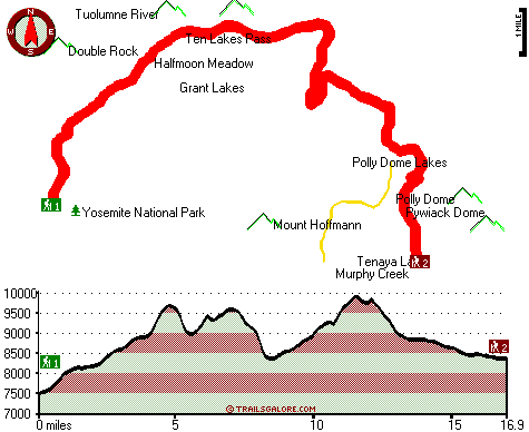
| |
|
| | A lengthy drive divides Phoenix Lake-Cedar Ridge from Ten Lakes Trail, but when you backcountry walk it you're always having a nice time. Every California great outdoors trail is well worth a backcountry walk. Backcountry trails are wonderful and plentiful in California; one of these is Ten Lakes Trail in Mariposa County. Being 33.8 miles long; it's a long hiking and backpacking trail. The high level of rain makes Ten Lakes Trail a reasonably wet spot; throughout January this area sees the most rain; the driest month is July. When you're here in California |
|
trekking along one of its great outdoors trails is a tremendous idea. Time to get out, and breathe some fresh air, and Ten Lakes Trail in Mariposa County, California is a nice pick. This is a wilderness hiking trail that is quite long, so make sure you bring plenty of supplies.
| | At parts of the year this neighborhood sees very little rain, so do check for current fire restrictions before you go if you plan to bring a stove or make a camp fire. California has lots of outdoors things to do. And keep in mind that there could be temporary safety restrictions in spot. Ten Lakes Trail goes through some very different elevations, so keep in mind that you may need to dress differently at different elevations. This is one of many backcountry trails in the surrounding area. Of course, this is an overnight backcountry hike, 5 days normally, | |
|
so make sure you've got all your overnight gear packed. For the duration of the days of summer at Ten Lakes Trail highs are regularly in the 80's with night lows in the 50's. The winter brings highs down to the 40's while the cold winter nights at Ten Lakes Trail are in the 20's.
The backcountry trails of the Central Sierra Nevada are the best way to enjoy these mountains. The length of Ten Lakes Trail is on the longer side having an average number of uphill miles which makes it a perfect backcountry trail for experienced hikers in perfect shape. The total
elevation difference for Ten Lakes Trail is 2,769 feet which is higher than average. Ten Lakes Trail is a two ended backpacking and hiking trail with two trailheads, so trekking it one way is an option if you can arrange for a ride back.
Briefly about the general area:
All our national parks are wonderful locations to stop by, and Yosemite National Park is no exception; there's whitewater on Tuolumne River for all you adrenaline people. This place is unbeatable, just check out all the fun things to do near Ten Lakes Trail. A perfect place near
Ten Lakes Trail is Ten Lakes Pass; if you're here at Ten Lakes Trail it's a nice idea to go to Halfmoon Meadow. If you like the outdoors you'll like it here in the Central Sierra Nevada. Take a little journey to Register Creek since you're here at Ten Lakes Trail, and Tenaya
Lake Campground is a pleasant local campground. You'll truly wish for more hours in a day to enjoy all the entertaining stuff in the Central Sierra Nevada. You can run the rapids of Yosemite Creek in close proximity to Ten Lakes Trail, and don't leave Ten Lakes Trail without first
paying a visit to Waterwheel Falls. Getting to Piute Creek from Ten Lakes Trail is easy, and if you came for an overnight stay Porcupine Flat Campground is a splendid location to camp. A pleasant trip to Pate Valley is a nice way to spend an afternoon, and the beauty of mother nature reveals herself at Snow Creek Falls.
|
|
Location of Trailhead 1: Latitude 37.8518, Longitude -119.5746 - - Directions and Road Map
Location of Trailhead 2: Latitude 37.8346, Longitude -119.4627 - - Directions and Road Map

Trailhead 1 to Trailhead 2: Total hiking length = 16.9 miles Total climbing distance = 8.7 miles Difficulty : Difficult Casual Hiking Pace:
2.5 days
Fast Hiking Pace:
9 hours
Trailhead 2 to Trailhead 1: Total hiking length = 16.9 miles Total climbing distance = 7 miles Difficulty : Difficult Casual Hiking Pace:
2.5 days
Fast Hiking Pace:
8 hours
| | Trailhead 1 back to Trailhead 1: Total hiking length = 33.8 miles Total climbing distance = 15.7 miles Difficulty : Difficult Casual Hiking Pace:
5 days
Fast Hiking Pace:
3.5 days
Trailhead 2 back to Trailhead 2: Total hiking length = 33.8 miles Total climbing distance = 15.7 miles Difficulty : Difficult Casual Hiking Pace:
5 days
Fast Hiking Pace:
3.5 days
|
Total elevation difference: 2769 feet

The Ahwahnee, Yosemite National Park
|
8 miles away
As a National Historical Landmark and one of the most distinctive resort hotels in North America, The Ahwahnee is well known for its great granite facade, striking beamed ceilings, massive stone heart...
|
| |
dnc -- Wawona Hotel, Yosemite National Park
|
13 miles away
Wawona is one of the oldest mountain resort hotels in California and a National Historic Landmark. Its verdant meadows, rushing streams, and tranquility make this a favorite of those who prefer a rela...
|
|
User input for Ten Lakes Trail, Central Sierra Nevada, Mariposa County, California:

Outdoors Recreation Near Phoenix Lake-Cedar Ridge, California Very comprehensive list of a variety of outdoors recreation in the vicinity of Phoenix Lake-Cedar Ridge, California, the metro area neareast to Ten Lakes Trail. Find info on campgrounds, hiking trails, ski resorts, lakes, beaches, parks, whitewater and more.
More Hotels and Campgrounds Near Ten Lakes Trail, Central Sierra Nevada, Mariposa County, California
| |
| |
 |
|
| These outdoors activities are available near Ten Lakes Trail. |
| | Trails Near Ten Lakes Trail:
 |
Tenaya Lake And Tuolumne Meadows Trail, Mariposa
County
, 6 miles away, 10.8 hiking miles, 910 feet elevation difference |
 |
Hetch Hetchy Trail, Mariposa
County
, 7 miles away, 7.7 hiking miles, 3804 feet elevation difference |
 |
North Dome Trail, Mariposa
County
, 7 miles away, 14.4 hiking miles, 4985 feet elevation difference |
 |
Eagle Peak Trail, Mariposa
County
, 7 miles away, 9.4 hiking miles, 3939 feet elevation difference |
 |
John Muir Trail - section 1,
County
, 8 miles away, 18.5 hiking miles, 6931 feet elevation difference |
 |
Half Dome Trail, Mariposa
County
, 8 miles away, 11.6 hiking miles, 5142 feet elevation difference |
 |
Yosemite Falls Trail, Mariposa
County
, 8 miles away, 9.4 hiking miles, 3958 feet elevation difference |
|
| | Whitewater Near Ten Lakes Trail:
 |
Tuolumne River, Tuolumne County
County
, 2 miles away, Class IV-V+ - 32 miles long (Tioga Road Bridge to Hetch Hetchy Reservoir) |
 |
Yosemite Creek, Mariposa County
County
, 5 miles away, Class IV-V - 8 miles long (Tioga Pass Road to Yosemite Falls) |
 |
Tenaya Creek, Mariposa County
County
, 7 miles away, Class V - 1 miles long (Super Slide) |
 |
Merced River, Mariposa County
County
, 14 miles away, Class V - 4.8 miles long (Routes 120-140 Junction to Arch Rock Entrance Station) |
 |
Merced River - South Fork, Mariposa County
County
, 19 miles away, Class V+ - 16 miles long (Upper) |
|
| | Hotels Near Ten Lakes Trail:
 |
The Ahwahnee, Yosemite National Park
, 8 miles away |
 |
dnc -- Wawona Hotel, Yosemite National Park
, 13 miles away |
 |
Yosemite Lodge at the Falls, Yosemite National Park
, 13 miles away |
 |
dnc -- Housekeeping Camp, Yosemite National Park
, 13 miles away |
 |
Curry Village, Yosemite National Park
, 13 miles away |
|
|
|
 |
|