| |
|
| | Backcountry trekking here in California is something that is always fun to do. Each hiking and backpacking trail in California has its own character. Put on your backpacking shoes, and hit the backcountry trail, Temelpa Trail in Marin County, California is a tremendous place to go. Don’t forget to check for any current restrictions or closures before you go. There's not much difference in elevation along Temelpa Trail, so you won’t have to worry about different climate zones along your backcountry hike. With its 2.8 miles of walking distance it's a shorter |
|
type backcountry hike. Temelpa Trail is not very in the vicinity of San Francisco-Oakland-Fremont at all, but backcountry trails like these are nice. There are so many backpacking trails in this region. Temelpa Trail is on the short side with an average amount of climbing distance
| | which makes it a splendid backpacking trail for the average person looking for a splendid adventure. You should count on this backcountry hike taking about 2.5 hours, but of course some folks walk a bit slower and some a bit faster. Temelpa Trail is a one trailhead trail, so you're looking at an in and out trek. This region does get very dry sometimes, so don’t forget to check for any current fire restrictions before you go. As long as you like the great outdoors you will like California. Temelpa Trail is a location that is relatively dry regularly; through | |
|
the month of January you get the most rain around here, and July on the other hand is the driest. Summer at Temelpa Trail arrives with high temperatures in the 80's while night lows are generally in the 50's. Through the wintertime this site gets highs in the 50's while Temelpa
Trail night low temperatures during the wintertime are in the 30's. Temelpa Trail is not that long but it's always great to bring some emergency supplies, you never know what could happen. Good hiking and backpacking trails in California are in abundance; one of them being Temelpa
Trail in Marin County. Temelpa Trail has a total elevation difference of 1,398 feet which is an average number.
Briefly about the general area: Colier Spring is an inspiring location to stop by while here, and a delightful beach nearby is Red Rock Beach. Cascade Creek
is one of the streams nearby that might be worth a visit; why not camp at Golden Gate Trailer Park if you're here at Temelpa Trail. Muir Beach is a beach in the vicinity of Temelpa Trail that you can take a look at; some close by water includes East Fork Fern Creek. Muir Woods
National Monument is a perfect national park. There's a forest here at Temelpa Trail called Miller Grove, and a wonderful spot to camp here at Temelpa Trail is Laurel Dell Campground. So much cool stuff to do at Temelpa Trail, so little time. At Cascade Dam near Temelpa Trail
there are some attention-grabbing things to see, and this is a popular site for people from San Francisco-Oakland-Fremont. Do set aside some time for Double Bowknot if you're here at Temelpa Trail, and a short tour to Dawn Falls is always worthwhile.
|
|
Location of Trailhead: Latitude 37.9182, Longitude -122.5811 - - Directions and Road Map
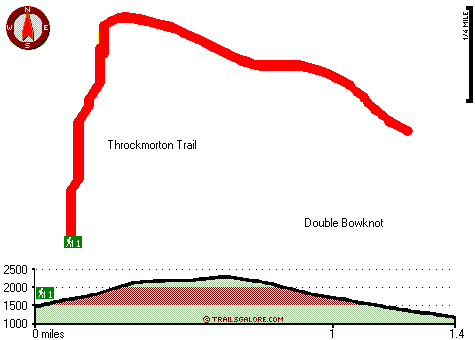
Total in and out hiking length = 2.8 miles
Total climbing distance = 1.2 miles
Difficulty : Medium
Casual Hiking Pace:
2.5 hours
Fast Hiking Pace:
1.5 hours
Total elevation difference: 1398 feet

Mill Valley Inn, Mill Valley
|
2 miles away
Tucked away in a redwood grove at the foot of majestic Mt. Tamalpais, the Mill Valley Inn combines the sophistication of a small European hotel with the cozy charm of a historic California mill town. ...
|
| |
Marin Suites Hotel, Corte Madera
|
4 miles away
Marin Suites Hotel- located centrally in beautiful - safe Marin County - offers spacious suites with full kitchens / living rooms / and private bedrooms. Complimentary amenities include an extended co...
|
|
User input for Temelpa Trail, Marin County, California:

Outdoors Recreation Near San Francisco-Oakland-Fremont, California Very comprehensive list of a variety of outdoors recreation in the vicinity of San Francisco-Oakland-Fremont, California, the metro area neareast to Temelpa Trail. Find info on campgrounds, hiking trails, ski resorts, lakes, beaches, parks, whitewater and more.
More Hotels and Campgrounds Near Temelpa Trail, Marin County, California
| |
| |
 |
|
| These outdoors activities are available near Temelpa Trail. |
| | Trails Near Temelpa Trail:
 |
Throckmorton Trail, Marin
County
, 1 miles away, 2.8 hiking miles, 1398 feet elevation difference |
 |
Bootjack Trail, Marin
County
, 1 miles away, 1.1 hiking miles, 950 feet elevation difference |
 |
North Side Trail, Marin
County
, 1 miles away, 4.8 hiking miles, 371 feet elevation difference |
 |
Lagunitas Fire Trail, Marin
County
, 1 miles away, 2.1 hiking miles, 1462 feet elevation difference |
 |
West Point Trail, Marin
County
, 1 miles away, 1 hiking miles, 1740 feet elevation difference |
 |
Ben Johnson Trail, Marin
County
, 2 miles away, 3.8 hiking miles, 1350 feet elevation difference |
 |
Colier Spring Trail, Marin
County
, 2 miles away, 2.6 hiking miles, 1292 feet elevation difference |
|
| | Beaches Near Temelpa Trail:
 |
Muir Beach, Marin County
, 4 miles away |
 |
Red Rock Beach, Marin County
, 5 miles away |
 |
Stinson Beach, Marin County
, 5 miles away |
 |
Rodeo Beach, Marin County
, 6 miles away |
 |
Gallinas Beach, Marin County
, 7 miles away |
|
| | National Parks Near Temelpa Trail:
 |
Muir Woods National Monument, Mill Valley - CA
, 2 miles away |
 |
Golden Gate National Recreation Area, San Francisco - CA
, 12 miles away |
 |
Presidio National Park, San Francisco - CA
, 12 miles away |
|
| | Hotels Near Temelpa Trail:
 |
Mill Valley Inn, Mill Valley
, 2 miles away |
 |
Marin Suites Hotel, Corte Madera
, 4 miles away |
 |
Best Western Corte Madera Inn, Corte Madera
, 4 miles away |
 |
Americas Best Value Inn-Corte Madera, Corte Madera
, 4 miles away |
 |
Travelodge Mill Valley/Sausalito, Mill Valley
, 4 miles away |
|
|
|
 |
|