| |
The trail on summit between summit trailhead and Magies Lakes is very difficult to follow (especially if there is still patches of snow on the ground). Be advised or you will get lost) GPS!!!!!!!!!! Last visited July 4th weekend 2010 Says Josh
The total elevation difference for this hiking and backpacking trail is 3,514 feet which is higher than average. This hiking and backpacking trail has only one trailhead, so in and out is the way to backcountry walk it normally. With its 51.4 miles of walking distance; it's considered a longer trek. This is a backpacking and hiking trail that is quite long, so don't forget to pack enough supplies. Different parts of Summit Trail are at very different elevations, so keep in mind that you may need to dress differently at different elevations. This vicinity does get very dry sometimes, so don’t forget to check for any current fire restrictions before you go. This trek should take you about 8 days, so better have big a backpack to fit all the stuff you need.
|
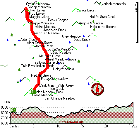
Total in and out hiking length = 51.4 miles
Total climbing distance = 24.2 miles
Difficulty : Difficult
Casual Hiking Pace:
8 days
Fast Hiking Pace:
5 days
Total elevation difference: 3514 feet
|


