California hiking trails - South Fork Trail, San Bernardino Mountains, San Bernardino County

   
  This part of California is always a joy to explore during backcountry trekking season. California has plenty of great hiking trails, and South Fork Trail in San Bernardino County is one of them. Spending too much time indoors got you down? No problem, South Fork Trail in San Bernardino County, California is just what you need. This is not a very long backcountry hiking trail but you should still bring some emergency supplies just in case something happens. The amount of precipitation that falls at South Fork Trail is close to the national average; January is
    when you get the most rain here, and the driest month of the year is June. Throughout the months of summer at South Fork Trail highs are commonly in the 80's while night lows are regularly in the 50's. High temperatures through the winter are normally in the 40's with temperatures
at South Fork Trail dipping down into the 20's through winter nights. South Fork Trail is 3.2 miles long it's a short great outdoors trail. Please follow all local rules about fires and camping. Every hiking trail in California is different from the others. South Fork Trail is a very short hiking trail having an average number of uphill miles which makes it a magnificent trail for the average person looking for a magnificent adventure. There are so many trails in this region. There's not much difference in elevation along the great outdoors trail, so  
you get pretty much the same conditions along the whole great outdoors trail. Backcountry backpacking here in California is always an enjoyable thing to do. This backcountry walk shouldn't take more than 2.5 hours, but you never know stuff could go wrong and you could get stuck so be prepared for that. This great outdoors hiking trail has a total elevation difference of 518 feet which is a lower than average number. Sometimes this backcountry hiking trail gets really dry, so don’t forget to check for any current fire restrictions before you go. This is a one trailhead great outdoors hiking trail, so you'll be backcountry hiking it in and back out. Backpacking and hiking trails like this one here in the San Bernardino Mountains are a splendid way to explore these hills. Relatively far from Riverside-San Bernardino-Ontario you come upon South Fork Trail, but when you spend some time backcountry hiking here you will feel like a whole new person.

Briefly about the general area:
Camping at Oso-Lobo Campground is always a fine experience It's always great to have a look at San Y Ca Spring. You just can't picture the amount of outdoors cool stuff the area near South Fork Trail has to offer.
A tremendous place to camp here at South Fork Trail is Council Campground; if you're popping by from Riverside-San Bernardino-Ontario, you won't be the only one. Man, is there a load of entertaining stuff to do in the San Bernardino Mountains. While you're here at South Fork Trail it's a good idea to stop at Horse Meadows, and a tour to High Meadow Springs will fill your spirit with wonderful feelings. You should absolutely dedicate some time to South Fork Meadows while you're here at South Fork Trail; Dollar Lake Saddle is another good location to go to nearby.

Location of Trailhead: Latitude 34.1496, Longitude -116.8546
- - Directions and Road Map

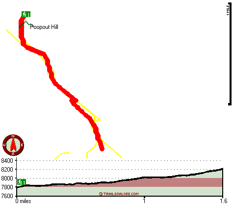
Total in and out hiking length = 3.2 miles

Total climbing distance = 1.2 miles

Difficulty : Medium

Casual Hiking Pace: 2.5 hours

Fast Hiking Pace: 1.5 hours

Total elevation difference: 518 feet


Best Western Big Bear Lake Chateau, Big Bear Lake
7 miles away
Full package information with prices is listed on the hotel amenities page. The Best Western Big Bear Chateau is centrally located between Bear Mountain and Snow Summit Ski Resorts. This full servi...
  
Snow Lake Lodge, Big Bear
7 miles away
Snow Lake Lodge is located in the Southern California mountains, next to Big Bear lake. Guests enjoy the beauty and splendor of majestic mountain views and clear lake waters....
User input for South Fork Trail, San Bernardino Mountains, San Bernardino County, California:

Submit Input:
Your Name:
Write or Paste Input here:

Upload picture:      Review Guidelines


Outdoors Recreation Near Riverside-San Bernardino-Ontario, California
Very comprehensive list of a variety of outdoors recreation in the vicinity of Riverside-San Bernardino-Ontario, California, the metro area neareast to South Fork Trail. Find info on campgrounds, hiking trails, ski resorts, lakes, beaches, parks, whitewater and more.

Current weather conditions at South Fork Trail, San Bernardino Mountains, San Bernardino County, California
WXPort

Local climate location: LAKE ARROWHEAD 18 miles away

Thundercloud Resort, Big Bear Lake
7 miles away
Accommodations at Thundercloud Resort are rustic and comfortable. We have a total of 64 rooms ranging from single bedrooms all the way up to two bedroom family suites. Many rooms include gas burning ...

Northwoods Resort And Conference Center, Big Bear Lake
7 miles away
Northwoods Resort and Conference Center is located in the beautiful San Bernardino Mountains, in Big Bear Lake, California, a premier mountain resort only a 2 1/2 hour drive from Los Angeles. Enjoy ye...

More Hotels and Campgrounds Near South Fork Trail, San Bernardino Mountains, San Bernardino County, California

OTHER_INFO
  San Bernardino Mountains Campgrounds
Complete list of all the campgrounds in the San Bernardino Mountains.

San Bernardino Mountains Outdoors Info
Complete outdoors info for the San Bernardino Mountains.

California Hiking Trails
Complete list of all hiking trails in California

Books about hiking trails in California
List of books available on Amazon.com about hiking trails in California.

California Outdoors Index
This is a very comprehensive index of outdoors activities in the great state of California.


TOPO
High quality water resistant topo map of South Fork Trail, San Bernardino Mountains, San Bernardino County, California.

OUTDOORS_GUIDE
These outdoors activities are available near South Fork Trail.
 Trails Near South Fork Trail:
Dollar Lake Trail, San Bernardino County , 1 miles away, 4.4 hiking miles, 2842 feet elevation difference
Dry Lake Trail, San Bernardino County , 2 miles away,  9.4 hiking miles, 2270 feet elevation difference
Falls Creek Trail, San Bernardino County , 2 miles away, 6.2 hiking miles, 5353 feet elevation difference
San Bernardino Peak Divide Trail, San Bernardino County , 3 miles away, 14.4 hiking miles, 5811 feet elevation difference
North Fork Meadows Trail, San Bernardino County , 3 miles away,  11.4 hiking miles, 2927 feet elevation difference
Fish Creek Trail, San Bernardino County , 3 miles away, 4.3 hiking miles, 1750 feet elevation difference
Forsee Creek Trail, San Bernardino County , 4 miles away,  11.8 hiking miles, 3896 feet elevation difference
 Camp Grounds Near South Fork Trail:
Oso-Lobo Campground, San Bernardino County, 2 miles away
Council Campground, San Bernardino County, 3 miles away
Falls Recreation Area, San Bernardino County, 4 miles away
Seven Oaks Lodge, Angelus Oaks, 6 miles away
Mission Springs Campground, San Bernardino County, 6 miles away
 National Parks Near South Fork Trail:
Mojave National Preserve, Barstow - CA , 45 miles away
Joshua Tree National Park, Twentynine Palms - CA , 55 miles away
 Hotels Near South Fork Trail:
Best Western Big Bear Lake Chateau, Big Bear Lake , 7 miles away
Snow Lake Lodge, Big Bear , 7 miles away
Thundercloud Resort, Big Bear Lake , 7 miles away
Northwoods Resort And Conference Center, Big Bear Lake , 7 miles away
Marina Resort, Big Bear Lake , 8 miles away
 Lakes Near South Fork Trail
Dollar Lake, San Bernardino County , 1 miles away
Dry Lake, San Bernardino County , 2 miles away

Outdoors related information copyright © Stratus-Pikpuk, Inc. - Detailed hotel information copyright © Interactive Hotel Solutions