| |
The total elevation difference for this wilderness hiking trail is 679 feet which is lower than average. This is a one trailhead wilderness hiking trail, so you'll be backcountry hiking it in and back out. This wilderness trail is not that long but you should still bring some emergency supplies just in case something happens. This backcountry walk shouldn't take more than 1 hours, but you never know stuff could go wrong and you could get stuck so be prepared for that. Sometimes this wilderness trail gets really dry, so do check for current fire restrictions before you go if you plan to bring a stove or make a camp fire. You spend the whole walk in roughly the same elevation zone, so you get pretty much the same conditions along the whole hiking trail. Being 1.2 miles long it's a shorter type walk.
|
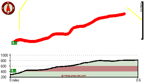
Total in and out hiking length = 1.2 miles
Total climbing distance = .4 miles
Difficulty : Medium
Casual Hiking Pace:
1 hours
Fast Hiking Pace:
.5 hours
Total elevation difference: 679 feet
|


