California hiking trails - Smoke Howe Trail, Klamath Mountains, Trinity County

   
  Each one of the many backcountry trails of California is well worth a hike. Put on your backpacking shoes, and hit the trail, if you happen to be in Trinity County of California, Smoke Howe Trail is a magnificent local trail for doing a bit of leg stretching. Backcountry hiking trails are good and plentiful in California, and Smoke Howe Trail in Trinity County is one of them. Backcountry backpacking here in California is so much fun. Smoke Howe Trail goes through some very different elevations, so keep in mind that you may need to dress differently at
    different elevations. Smoke Howe Trail has only one trailhead, so you're looking at an in and out walk. This backcountry trail has a total elevation difference of 1,983 feet, and that is about average. California is a brilliant outdoors state. This is a long hiking and backpacking
trail, so do pack enough food to last the whole trip. You should count on this hike taking about 7 hours, but you never know stuff could go wrong and you could get stuck so be prepared for that. With its 7.8 miles of walking distance it's a mid length walk. This is one of many backcountry trails in the surrounding region. High temperatures at Smoke Howe Trail throughout the summer are in the 90's. When the night sets in temperatures dip down into the 50's. The cold days of the wintertime come with highs in the 40's while Smoke Howe Trail overnight low  
temperatures during the wintertime are in the 30's. Don’t forget to check for any current restrictions or closures before you go. Smoke Howe Trail is a normal length wilderness hiking trail with an average amount of climbing distance which makes it an excellent backcountry trail for experienced backcountry hikers in fine shape. Smoke Howe Trail gets a typical amount of annual rain; January is when you get the most rain here while July is the month with the least amount of precipitation. This hiking and backpacking trail sometimes gets very dry, so do check for current fire restrictions before you go if you plan to bring a stove or make a camp fire. Smoke Howe Trail is relatively secluded from the nearest city, and backpacking is such a fun thing to do, and this is a magnificent place to do that. Backcountry trekking here in the Klamath Mountains is a really fine way to spend quality time in the great outdoors.

Briefly about the general area:
All the outdoors fun stuff close to Smoke Howe Trail will keep you coming back time and again. It's always magnificent to take a look at Green Springs. Hammerhorn Campground is a fine local campground, and Buck Rock Creek is one of the streams close by that might be worth taking a look at.
Having a wonderful time in the Klamath Mountains is simple. If you come at the right time of year, Black Butte River offers some good whitewater; there's some flowing water close by, Smokehouse Creek is a stream you can take a look at while here. A tour to French Cove is always fun; sites like Barney Meadow are wonderful to visit. Smoke Howe Trail is a fine site to visit for more than one day, Little Doe Campground is a fine site to camp nearby, and Pony Meadows is a charming site any time of year.

Location of Trailhead: Latitude 39.9565, Longitude -122.9596
- - Directions and Road Map

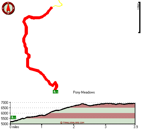
Total in and out hiking length = 7.8 miles

Total climbing distance = 3.4 miles

Difficulty : Difficult

Casual Hiking Pace: 7 hours

Fast Hiking Pace: 4.5 hours

Total elevation difference: 1983 feet


Super 8 Motel - Willits, Willits
40 miles away
Welcome to Willits, CA, located in the heart of Mendocino County. Willits offers many activities in and around the community, and gives you firsthand experience of small town America at its finest. ...
  
Clarion Collection Baechtel Creek Inn & Spa, Willits
40 miles away
The Clarion Collection Baechtel Creek Inn is located in the heart of Mendocino County allowing easy access to the Redwoods, the coast, and wineries. This is the only hotel in Willits that sits off the...
User input for Smoke Howe Trail, Klamath Mountains, Trinity County, California:

Submit Input:
Your Name:
Write or Paste Input here:

Upload picture:      Review Guidelines


Outdoors Recreation Near Ukiah, California
Very comprehensive list of a variety of outdoors recreation in the vicinity of Ukiah, California, the metro area neareast to Smoke Howe Trail. Find info on campgrounds, hiking trails, ski resorts, lakes, beaches, parks, whitewater and more.

Current weather conditions at Smoke Howe Trail, Klamath Mountains, Trinity County, California
WXPort

Local climate location: BIG BAR RANGER STATION 27 miles away

Baechtel Creek Inn and Spa, Willits
40 miles away
Centrally located in the 'Heart of Mendocino County', Willits is known as the 'Gateway to the Redwoods' going North and the 'Gateway to the Wine Country' going South. We are the only Inn in Willits t...

Best Western Willits Inn, Willits
40 miles away
The Best Western Willits Inn is Willits' newest and finest motel. The comfort and style of a one-of-a-kind motel will make your stay in Willits one you will not soon forget. We are conveniently loca...

More Hotels and Campgrounds Near Smoke Howe Trail, Klamath Mountains, Trinity County, California

OTHER_INFO
  Klamath Mountains Campgrounds
Complete list of all the campgrounds in the Klamath Mountains.

Klamath Mountains Outdoors Info
Complete outdoors info for the Klamath Mountains.

California Hiking Trails
Complete list of all hiking trails in California

Books about hiking trails in California
List of books available on Amazon.com about hiking trails in California.

California Outdoors Index
This is a very comprehensive index of outdoors activities in the great state of California.


TOPO
High quality water resistant topo map of Smoke Howe Trail, Klamath Mountains, Trinity County, California.

OUTDOORS_GUIDE
These outdoors activities are available near Smoke Howe Trail.
 Trails Near Smoke Howe Trail:
French Trail, Mendocino County , 2 miles away,  6 hiking miles, 1080 feet elevation difference
Soldier Trail, Trinity County , 2 miles away,  10 hiking miles, 1853 feet elevation difference
Wrights Ridge Trail, Trinity County , 6 miles away,  17.8 hiking miles, 2820 feet elevation difference
Ides Cove National Recreation Trail, Tehama County , 6 miles away, 12 hiking miles, 1863 feet elevation difference
Cutfinger Trail, Trinity County , 7 miles away,  7.2 hiking miles, 1276 feet elevation difference
Devils Hole Ridge Trail, Trinity County , 7 miles away,  19.2 hiking miles, 633 feet elevation difference
Lazyman Butte Trail, Tehama County , 8 miles away,  24 hiking miles, 3886 feet elevation difference
 Camp Grounds Near Smoke Howe Trail:
Hammerhorn Campground, Mendocino County, 2 miles away
Little Doe Campground, Mendocino County, 5 miles away
Boardman Ridge Campground, Mendocino County, 7 miles away
Sugar Spring Campground, Tehama County, 8 miles away
Wells Cabin Campground, Tehama County, 8 miles away
 Whitewater Near Smoke Howe Trail:
Black Butte River, Glenn / Mendocino County County , 14 miles away, Class IV+ - 24 miles long (Headwaters at Basin to Middle Fork Eel)
 National Parks Near Smoke Howe Trail:
Whiskeytown National Recreation Area, Whiskeytown - CA , 46 miles away
 Hotels Near Smoke Howe Trail:
Super 8 Motel - Willits, Willits , 40 miles away
Clarion Collection Baechtel Creek Inn & Spa, Willits , 40 miles away
Baechtel Creek Inn and Spa, Willits , 40 miles away
Best Western Willits Inn, Willits , 40 miles away
Tallman Hotel, Upper Lake , 43 miles away
 Lakes Near Smoke Howe Trail
Hammerhorn Lake, Mendocino County , 2 miles away

Outdoors related information copyright © Stratus-Pikpuk, Inc. - Detailed hotel information copyright © Interactive Hotel Solutions