California hiking trails - Silver King Trail, Central Sierra Nevada, Alpine County

   
  Backcountry hiking here in California is a fine way to spend some time. This part of California has a magnificent deal of available outdoors pastimes. You can't spend all your time indoors you need to get out once in a while, and Silver King Trail in Alpine County, California is a wonderful site for getting out. This is a backpacking trail that is quite long, so do pack enough food to last the whole trip. This backcountry hike should take you about 3.5 days, so make sure you've got all your overnight gear packed. There are plenty of wilderness trails
    in California; each one of them is worth hiking. This backpacking trail sometimes gets very dry, so make sure you check current conditions and fire restrictions with local forest authorities before you head out. Silver King Trail is a location that is pretty dried up mostly; of
all the months in a year January is the one with the most rain, and the driest of the months is July. There is only one trailhead, so in and out is the way to trek it normally. It's a long drive from Gardnerville Ranchos to Silver King Trail, but many folks like to backcountry hike here to be near the outdoors. Silver King Trail goes through some very different elevations, so keep in mind that you may need to dress differently at different elevations. Please follow all local rules about fires and camping. The total elevation difference for this hiking  
and backpacking trail is 1,976 feet which is an average number. Wonderful wilderness trails in California are in abundance, and among these are Silver King Trail in Alpine County. There are so many backpacking trails in this area. Silver King Trail is many miles long having an average number of uphill miles which makes this a very tough backpacking trail for advanced backcountry trekkers looking for a splendid challenge. Through the months of summer, highs mostly are in the 80's at Silver King Trail. During the dark hours of summer temperatures plunge down into the 50's. During the winter highs are in the 40's while Silver King Trail overnight low temperatures through the wintertime are in the 20's. With its 23.6 miles of walking distance; it's considered a longer walk. Backpacking trails like this one here in the Central Sierra Nevada are the best way to enjoy these hills.

Briefly about the general area:
You just can't picture the amount of outdoors cool things the Central Sierra Nevada has to offer. Getting to Corral Valley Creek from Silver King Trail is simple, and paddling on West Walker River is so much fun. And if you're still looking for more outdoors entertaining things just keep reading. If you would like a little side journey, try Lower Fish Valley; don’t forget to stop at Poison Flat if you're here at Silver King Trail.
Having a tremendous time in the Central Sierra Nevada is simple. Some nearby water includes Tamarack Creek It's always good to explore Carson Falls. Do set aside some time for Fly Valley if you're here at Silver King Trail; Topaz Lake RV Park is a good campground nearby.
Don't leave Silver King Trail without first paying a visit to Llewellyn Falls; Leavitt Meadows Campground is a wonderful local campground.

Location of Trailhead: Latitude 38.5768, Longitude -119.6356
- - Directions and Road Map

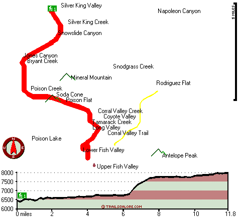
Total in and out hiking length = 23.6 miles

Total climbing distance = 9 miles

Difficulty : Difficult

Casual Hiking Pace: 3.5 days

Fast Hiking Pace: 2 days

Total elevation difference: 1976 feet


Super 8 Gardnerville/Carson City, Gardnerville
13 miles away
Located on Topaz Lake, fishing, hiking, watersports, camping Sweetwater Mtn views Downtown Gardnerville - 20 mi Mommoth Lakes - 90 mi Reno - 70 mi Lake Tahoe - 40 mi Yosemite Nat'l Park - 150 mi Topaz...
  
Best Western Topaz Lake Inn, Topaz Lake
13 miles away
The Best Western Topaz Lake Inn features modern accommodations and a spectacular view of Topaz Lake and the surrounding mountains, from every room. Located on the eastern slope of the Sierra's at the...
User input for Silver King Trail, Central Sierra Nevada, Alpine County, California:

Submit Input:
Your Name:
Write or Paste Input here:

Upload picture:      Review Guidelines


Outdoors Recreation Near Gardnerville Ranchos, Nevada
Very comprehensive list of a variety of outdoors recreation in the vicinity of Gardnerville Ranchos, Nevada, the metro area neareast to Silver King Trail. Find info on campgrounds, hiking trails, ski resorts, lakes, beaches, parks, whitewater and more.

Current weather conditions at Silver King Trail, Central Sierra Nevada, Alpine County, California
WXPort

Local climate location: WOODFORDS 8 miles away

David Walley's Resort, Genoa
26 miles away
Nestled in the shadow of the majestic Sierra Nevadas, 12 and a half miles east of South Lake Tahoe. David Walleys Resort, Hot Springs and Spa is a year-round destination featuring all the amenities of...

The Mountain Club, Kirkwood
28 miles away
Guests at The Mountain Club can enjoy premium ski in/ski out lodging in the heart of the Mountain Village. Unit sizes range from hotel style units to 2 bedroom plus loft condominiums. These rooms prov...

More Hotels and Campgrounds Near Silver King Trail, Central Sierra Nevada, Alpine County, California

OTHER_INFO
  Central Sierra Nevada Campgrounds
Complete list of all the campgrounds in the Central Sierra Nevada.

Central Sierra Nevada Outdoors Info
Complete outdoors info for the Central Sierra Nevada.

California Hiking Trails
Complete list of all hiking trails in California

Books about hiking trails in California
List of books available on Amazon.com about hiking trails in California.

California Outdoors Index
This is a very comprehensive index of outdoors activities in the great state of California.


TOPO
High quality water resistant topo map of Silver King Trail, Central Sierra Nevada, Alpine County, California.

OUTDOORS_GUIDE
These outdoors activities are available near Silver King Trail.
 Trails Near Silver King Trail:
Corral Valley Trail, Alpine County , 1 miles away,  7.4 hiking miles, 756 feet elevation difference
Early Emigrant and Indian Trail, Mono County , 7 miles away, 7.6 hiking miles, 2323 feet elevation difference
Lost Canyon Trail, Mono County , 8 miles away, 9.9 hiking miles, 3648 feet elevation difference
Pacific Crest Trail - section 13, County , 13 miles away, 66 hiking miles, 3818 feet elevation difference
 Camp Grounds Near Silver King Trail:
Leavitt Meadows Campground, Mono County, 9 miles away
Topaz Lake RV Park, Topaz, 10 miles away
Leavitt Meadows Pack Station, Coleville, 10 miles away
Sonora Bridge Campground, Mono County, 11 miles away
Centerville Flat Campground, Alpine County, 11 miles away
 Whitewater Near Silver King Trail:
West Walker River, Mono County County , 9 miles away, Class IV-V - 2.3 miles long (Leavitt Station Trailhead to Pickel Meadow)
West Walker River, Mono County County , 10 miles away, Class III-V - 11 miles long (Highway 395 Bridge to Walker)
Carson River - East Fork, Alpine County County , 14 miles away, Class III - 7.3 miles long (Cave Rock to Hangman's Bridge)
Carson River - East Fork, Alpine County County , 16 miles away, Class II - 20 miles long (Hangman's Bridge to Gardnerville)
Carson River - East Fork, Alpine County County , 18 miles away, Class II - 20 miles long (Hangman's Bridge to CA-NV border)
 National Parks Near Silver King Trail:
Yosemite National Park, Yosemite National Park - CA , 49 miles away
 Hotels Near Silver King Trail:
Super 8 Gardnerville/Carson City, Gardnerville , 13 miles away
Best Western Topaz Lake Inn, Topaz Lake , 13 miles away
David Walley's Resort, Genoa , 26 miles away
The Mountain Club, Kirkwood , 28 miles away
Carson Valley Inn, Minden , 28 miles away

Outdoors related information copyright © Stratus-Pikpuk, Inc. - Detailed hotel information copyright © Interactive Hotel Solutions