California hiking trails - Second Divide Trail, Northern Sierra Nevada, Sierra County

   
  Going for a backcountry hike here in California never gets boring. A long drive parts Truckee-Grass Valley from Second Divide Trail, but it is a really fine backpacking trail. There are plenty of backcountry trails in California; each one of them is worth backcountry hiking. Summer at Second Divide Trail arrives with high temperatures in the 90's. For the duration of the moonlight hours it's ordinarily in the 40's. High temperatures all through the winter are normally in the 40's, and nighttime lows at Second Divide Trail all through the winter ordinarily
    descend into the 20's. Tremendous backcountry trails in California are in abundance; Second Divide Trail is one of them, and it's in Sierra County. Second Divide Trail has a total elevation difference of 1,442 feet which is an average number. There are so many hiking and backpacking
trails in this region. Second Divide Trail gets a common amount of rainfall; the month of January is the wettest with most of the rain while July is regularly the driest month. And keep in mind that there could be temporary safety restrictions in location. Second Divide Trail has only one trailhead, so you're looking at an in and out backcountry hike. Time to get out, and breathe some fresh air, and if you happen to be in Sierra County of California, Second Divide Trail is a glorious local backpacking trail for doing a bit of leg stretching. This hiking  
trail sometimes gets very dry, so don’t forget to check for any current fire restrictions before you go. The beautiful hiking trails of the Northern Sierra Nevada are the best way to enjoy these mountains. Second Divide Trail stays roughly within the same elevation zone the whole time which means the conditions are about the same from start to finish. The time needed for this backcountry trek is roughly 6.5 hours, but you never know stuff could go wrong and you could get stuck so be prepared for that. Being 7.2 miles long it's an average length wilderness trail. Keep in mind that this is a long hiking trail, so make sure you bring plenty of supplies. Backcountry backpacking in California is such a great thing to do. Second Divide Trail is a normal length hiking trail with an average amount of climbing distance which makes it an excellent hiking and backpacking trail for experienced backcountry trekkers in good shape.

Briefly about the general area:
You can run the rapids of Pauley Creek near Second Divide Trail; Second Divide Trail is not far at all from Truckee-Grass Valley. Not enough hours in a day to enjoy this spot. A pleasant journey to China Flat is a delightful way to spend an afternoon.
Visit Empire Creek if you're here at Second Divide Trail, and camping at Union Flat Campground is always a good experience. Jim Crow Creek is a picturesque stream that is worth taking a look at; nearby Third Divide is a pleasant place to go. All year is a pleasant time in the Northern Sierra Nevada if you like the outdoors. A nice place to camp here at Second Divide Trail is Cannon Point Campground, and get your heart beating on the wonderful whitewater of Lavezzola Creek.

Location of Trailhead: Latitude 39.5976, Longitude -120.7976
- - Directions and Road Map

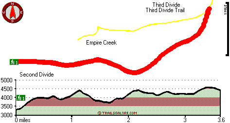
Total in and out hiking length = 7.2 miles

Total climbing distance = 3.2 miles

Difficulty : Difficult

Casual Hiking Pace: 6.5 hours

Fast Hiking Pace: 4 hours

Total elevation difference: 1442 feet


Deer Creek Inn, Nevada City
14 miles away
Deer Creek Inn is a 150 year old restored Queen Anne Victorian located in the historic Gold Rush town of Nevada City, California. The historic shopping and dining district on Broad Street is only foot...
  
Chalet View Lodge, Graeagle
18 miles away
User input for Second Divide Trail, Northern Sierra Nevada, Sierra County, California:

Submit Input:
Your Name:
Write or Paste Input here:

Upload picture:      Review Guidelines


Outdoors Recreation Near Truckee-Grass Valley, California
Very comprehensive list of a variety of outdoors recreation in the vicinity of Truckee-Grass Valley, California, the metro area neareast to Second Divide Trail. Find info on campgrounds, hiking trails, ski resorts, lakes, beaches, parks, whitewater and more.

Current weather conditions at Second Divide Trail, Northern Sierra Nevada, Sierra County, California
WXPort

Local climate location: QUINCY 13 miles away

Nevada City Inn, Nevada City
25 miles away
A home away from home! Comfortable, park-like setting, 2/3 of a mile to downtown Nevada City, 27 guest rooms inluding 7 cottages. We are now an all non smoking room hotel. We are a pet friendly hotel...

Piety Hill Cottages, Nevada City
25 miles away
9 Tastefully appointed BnB cottages in this parklike setting 1 acre with tree-shaded grassy courtyard...

More Hotels and Campgrounds Near Second Divide Trail, Northern Sierra Nevada, Sierra County, California

OTHER_INFO
  Northern Sierra Nevada Campgrounds
Complete list of all the campgrounds in the Northern Sierra Nevada.

Northern Sierra Nevada Outdoors Info
Complete outdoors info for the Northern Sierra Nevada.

California Hiking Trails
Complete list of all hiking trails in California

Books about hiking trails in California
List of books available on Amazon.com about hiking trails in California.

California Outdoors Index
This is a very comprehensive index of outdoors activities in the great state of California.


TOPO
High quality water resistant topo map of Second Divide Trail, Northern Sierra Nevada, Sierra County, California.

OUTDOORS_GUIDE
These outdoors activities are available near Second Divide Trail.
 Trails Near Second Divide Trail:
Third Divide Trail, Sierra County , 1 miles away, 2.5 hiking miles, 2062 feet elevation difference
Butcher Ranch Trail, Sierra County , 3 miles away, 3 hiking miles, 2125 feet elevation difference
Pacific Crest Trail - section 15, County , 7 miles away, 109.3 hiking miles, 6884 feet elevation difference
Bedbug Smith Trail, Sierra County , 7 miles away,  6.2 hiking miles, 1927 feet elevation difference
Deer Lake Trail, Sierra County , 8 miles away, 3.6 hiking miles, 1145 feet elevation difference
Bayes Cabin Road, Nevada County , 8 miles away,  3.4 hiking miles, 1568 feet elevation difference
Eureka Lake Trail, Plumas County , 9 miles away, 1.4 hiking miles, 1203 feet elevation difference
 Camp Grounds Near Second Divide Trail:
Union Flat Campground, Sierra County, 2 miles away
Cannon Point Campground, Sierra County, 5 miles away
Middlewaters Campground, Sierra County, 7 miles away
Ross Campground, Plumas County, 7 miles away
Loganville Campground, Sierra County, 8 miles away
 Whitewater Near Second Divide Trail:
Lavezzola Creek, Sierra County County , 3 miles away, Class IV(V) - 4 miles long (2nd Divide Bridge to Downieville)
Pauley Creek, Sierra County County , 3 miles away, Class III-IV - 4 miles long (Second Divide Turnout to Downieville)
Yuba River - North Fork, Sierra County County , 4 miles away, Class IV-V - 13 miles long (Wild Plum Campground to Downieville)
Yuba River - North Fork, Sierra County County , 7 miles away, Class II-V - 4 miles long (Downieville to Goodyears Bar Bridge)
Yuba River - North Fork, Sierra County County , 13 miles away, Class IV - 8.5 miles long (Goodyears Bar Bridge to Highway 49 Bridge)
 National Parks Near Second Divide Trail:
Lassen Volcanic National Park, Mineral - CA , 68 miles away
 Hotels Near Second Divide Trail:
Deer Creek Inn, Nevada City , 14 miles away
Chalet View Lodge, Graeagle , 18 miles away
Nevada City Inn, Nevada City , 25 miles away
Piety Hill Cottages, Nevada City , 25 miles away
Best Western Gold Country Inn, Grass Valley , 27 miles away
 Lakes Near Second Divide Trail
Smith Lake, Sierra County , 4 miles away

Outdoors related information copyright © Stratus-Pikpuk, Inc. - Detailed hotel information copyright © Interactive Hotel Solutions