| |
|
| | Delightful backpacking and hiking trails in California are in abundance, and Santa Anita Trail in Los Angeles County is one of them. No chance of getting bored in California if you like the great outdoors. It's a long tour from Los Angeles-Long Beach-Santa Ana to Santa Anita Trail, but trekking it is always exciting. Here in California trekking is always a cool thing to do. Santa Anita Trail has a total elevation difference of 2,891 feet, and that is higher than average. This trail has only one trailhead, so you'll be hiking it in and back out. During the |
|
warmest time of the year at Santa Anita Trail temperatures are mostly in the 80's while night lows are typically in the 60's. For the period of the wintertime the highs are typically in the 50's, and winter nights come with lows in the 30's to Santa Anita Trail. Santa Anita Trail
| | gets very little rainfall; of all the months in a year March is the one with the most rain, and the driest month is July. These great outdoors hiking trails here in the San Gabriel Mountains are a very good way to see these mountaintops. Hitting the hiking trails is always an amusing thing to do, and Santa Anita Trail in Los Angeles County, California is such a perfect place. The time needed for this backcountry trek is roughly 3.5 hours, but of course some people walk a bit slower and some a bit faster. This great outdoors hiking trail is not that long but | |
|
you should still bring some emergency supplies just in case something happens. The length of this great outdoors hiking trail is about average with an average amount of climbing distance which makes it a perfect wilderness hiking trail for the average person looking for a perfect
adventure. Each one of the many backpacking and hiking trails of California is well worth a backcountry walk. And keep in mind that there could be temporary safety restrictions in place. Different parts of this wilderness trail are at very different elevations, so keep in mind
that you may need to dress differently at different elevations. There are so many wilderness hiking trails in this vicinity. Santa Anita Trail is 4.2 miles long it's an average length wilderness trail. Sometimes this great outdoors hiking trail gets really dry, so make sure you
check current conditions and fire restrictions with local forest authorities before you head out.
Briefly about the general area: The beauty of mother nature reveals herself at Sturtevant Falls, and a magnificent spot to camp here at Santa Anita Trail is Hoegee Campground.
Visit Rush Creek while you're here at Santa Anita Trail, and Chantry Flat is right here at Santa Anita Trail. Newcomb Pass is a great site to visit in the neighborhood of Santa Anita Trail, and Santa Anita Trail is great enough to spend more than a day at, Spruce Grove Campground
is a great local campground. If you want a delightful time in the great outdoors just come on up to the San Gabriel Mountains. People from Los Angeles-Long Beach-Santa Ana love to come to Santa Anita Trail; don't forget to take a brilliant little journey to Winter Creek. You'll wish for more hours in a day to enjoy all the enjoyable stuff at Santa Anita Trail.
|
|
Location of Trailhead: Latitude 34.2265, Longitude -118.056 - - Directions and Road Map
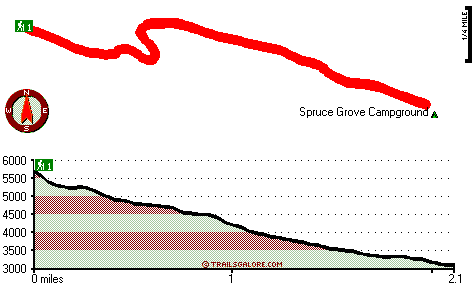
Total in and out hiking length = 4.2 miles
Total climbing distance = 1.7 miles
Difficulty : Medium
Casual Hiking Pace:
3.5 hours
Fast Hiking Pace:
2.5 hours
Total elevation difference: 2891 feet

|
| |
Santa Anita Inn, Arcadia
|
5 miles away
The Santa Anita Inn has been totally restored to the finest hotel in the San Gabriel Valley. We offer you a resort-like atmosphere (5 1/2 acres of landscaping) in the midst of the city. Our grounds ma...
|
|
User input for Santa Anita Trail, San Gabriel Mountains, Los Angeles County, California:

Outdoors Recreation Near Los Angeles-Long Beach-Santa Ana, California Very comprehensive list of a variety of outdoors recreation in the vicinity of Los Angeles-Long Beach-Santa Ana, California, the metro area neareast to Santa Anita Trail. Find info on campgrounds, hiking trails, ski resorts, lakes, beaches, parks, whitewater and more.
More Hotels and Campgrounds Near Santa Anita Trail, San Gabriel Mountains, Los Angeles County, California
| |
| |
 |
|
| These outdoors activities are available near Santa Anita Trail. |
| | Trails Near Santa Anita Trail:
 |
Winter Creek Trail, Los Angeles
County
, 1 miles away, 3.2 hiking miles, 2924 feet elevation difference |
 |
Upper Winter Creek Trail, Los Angeles
County
, 1 miles away, 4.8 hiking miles, 3976 feet elevation difference |
 |
Mount Wilson Trail, Los Angeles
County
, 2 miles away, 5.6 hiking miles, 4576 feet elevation difference |
 |
Gabrielino National Scenic Trail, Los Angeles
County
, 2 miles away, 19.9 hiking miles, 3843 feet elevation difference |
 |
Valley Forge Trail, Los Angeles
County
, 3 miles away, 3.2 hiking miles, 1606 feet elevation difference |
 |
Idlehour Trail, Los Angeles
County
, 4 miles away, 6.2 hiking miles, 2028 feet elevation difference |
 |
Condor Peak Riding and hiking Trail, Los Angeles
County
, 12 miles away, 8.6 hiking miles, 3552 feet elevation difference |
|
| | Hotels Near Santa Anita Trail:
 |
Springhill Suites By Marriott Pasadena/Arcadia, Arcadia
, 5 miles away |
 |
Santa Anita Inn, Arcadia
, 5 miles away |
 |
Hilton Garden Inn Arcadia/Pasadena Area, Arcadia
, 5 miles away |
 |
Embassy Suites Hotel Arcadia-Pasadena Area, Arcadia
, 5 miles away |
 |
Residence Inn By Marriott Arcadia, Arcadia
, 5 miles away |
|
|
|
 |
|