| |
|
| | Hiking and backpacking trails for backcountry hiking, and backpacking can be found all over California, and San Bernardino Peak Divide Trail is one of them, and it's in San Bernardino County. Going for a backcountry walk here in California is always an amusing thing to do. Each backcountry hiking trail in California has its own character. This is a region covered with lots of hiking trails. This is a two-ended wilderness hiking trail with two trailheads, so if you can get a ride from someone, you can backcountry hike it just one way. Being 28.8 miles |
|
long; it's considered a longer backcountry hike. San Bernardino Peak Divide Trail is quite long, so make sure you bring plenty of supplies. San Bernardino Peak Divide Trail gets a typical amount of annual rain; through the month of January you get the most rain around here, and
| | the driest month of the year is June. San Bernardino Peak Divide Trail is a long journey away from Riverside-San Bernardino-Ontario, but when you hike it you're always having a magnificent time. This backcountry walk should take you about 4.5 days, so it's a nice thing if your backpack is big enough to do the job. The warmest time of the year brings highs in the 80's to San Bernardino Peak Divide Trail. All through the moonlight hours it's generally in the 50's. High temperatures through the winter are normally in the 40's, and through the dark hours | |
|
in the winter at San Bernardino Peak Divide Trail temperatures plunge to the 20's. This wilderness hiking trail has a total elevation difference of 5,811 feet which is a higher than average number. The lovely backcountry trails of the San Bernardino Mountains are a perfect way
to explore these summits. Sometimes this wilderness hiking trail gets really dry, so do check for current fire restrictions before you go if you plan to bring a stove or make a camp fire. Please follow all local rules about fires and camping. Some parts of San Bernardino Peak Divide
Trail are much higher up than other parts of the trail which of course means you need to be prepared for different conditions on different parts of the trail. San Bernardino Peak Divide Trail is a backcountry trail of great length having an average number of uphill miles which
makes this hiking trail nice for hard core backpackers looking for adventure. Gotta get out of the city man, and San Bernardino Peak Divide Trail in San Bernardino County, California is just the site. A visit to California is not complete without some backcountry trekking.
Briefly
about the general area: There's no way someone can get bored here in the San Bernardino Mountains. San Bernardino Peak Divide Trail is a place with many visitors from Riverside-San Bernardino-Ontario, and a splendid location like Shields Flat here at San Bernardino Peak Divide
Trail is too fine to miss. A tour to Trail Fork Springs will fill your soul with glorious feelings; if you're looking for some flowing water? Try Falls Creek. There's just no way anyone can get bored here at San Bernardino Peak Divide Trail. Rattlesnake Creek is a pleasant
local stream, and if you're here, do take a journey to Gibralter Point. So much fun stuff to do in the San Bernardino Mountains, not sufficient time. Put some time aside to spend at High Meadow Springs while you're here at San Bernardino Peak Divide Trail, and Dollar Lake Saddle
is a magnificent spot to stop at. Falls Recreation Area is a wonderful campground here, and Anderson Flat is a delightful site here at San Bernardino Peak Divide Trail. San Bernardino Peak Divide Trail is a good site to camp, Council Campground is a good site, and there's a glorious forest called San Bernardino National Forest.
|
|
Location of Trailhead 1: Latitude 34.1469, Longitude -116.9774 - - Directions and Road Map
Location of Trailhead 2: Latitude 34.1016, Longitude -116.8341 - - Directions and Road Map

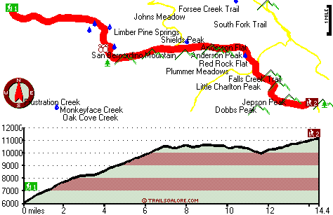
Trailhead 1 to Trailhead 2: Total hiking length = 14.4 miles Total climbing distance = 10.2 miles Difficulty : Difficult Casual Hiking Pace:
2.5 days
Fast Hiking Pace:
8.5 hours
Trailhead 2 to Trailhead 1: Total hiking length = 14.4 miles Total climbing distance = 2.3 miles Difficulty : Difficult Casual Hiking Pace:
1.5 days
Fast Hiking Pace:
5.5 hours
| | Trailhead 1 back to Trailhead 1: Total hiking length = 28.8 miles Total climbing distance = 12.5 miles Difficulty : Difficult Casual Hiking Pace:
4.5 days
Fast Hiking Pace:
3 days
Trailhead 2 back to Trailhead 2: Total hiking length = 28.8 miles Total climbing distance = 12.5 miles Difficulty : Difficult Casual Hiking Pace:
4.5 days
Fast Hiking Pace:
3 days
|
Total elevation difference: 5811 feet

Snow Lake Lodge, Big Bear
|
7 miles away
Snow Lake Lodge is located in the Southern California mountains, next to Big Bear lake. Guests enjoy the beauty and splendor of majestic mountain views and clear lake waters....
|
| |
Northwoods Resort And Conference Center, Big Bear Lake
|
7 miles away
Northwoods Resort and Conference Center is located in the beautiful San Bernardino Mountains, in Big Bear Lake, California, a premier mountain resort only a 2 1/2 hour drive from Los Angeles. Enjoy ye...
|
|
User input for San Bernardino Peak Divide Trail, San Bernardino Mountains, San Bernardino County, California:

Outdoors Recreation Near Riverside-San Bernardino-Ontario, California Very comprehensive list of a variety of outdoors recreation in the vicinity of Riverside-San Bernardino-Ontario, California, the metro area neareast to San Bernardino Peak Divide Trail. Find info on campgrounds, hiking trails, ski resorts, lakes, beaches, parks, whitewater and more.
More Hotels and Campgrounds Near San Bernardino Peak Divide Trail, San Bernardino Mountains, San Bernardino County, California
| |
| |
 |
|
| These outdoors activities are available near San Bernardino Peak Divide Trail. |
| | Trails Near San Bernardino Peak Divide Trail:
 |
Forsee Creek Trail, San Bernardino
County
, 1 miles away, 11.8 hiking miles, 3896 feet elevation difference |
 |
Falls Creek Trail, San Bernardino
County
, 1 miles away, 6.2 hiking miles, 5353 feet elevation difference |
 |
Dollar Lake Trail, San Bernardino
County
, 3 miles away, 4.4 hiking miles, 2842 feet elevation difference |
 |
South Fork Trail, San Bernardino
County
, 3 miles away, 3.2 hiking miles, 518 feet elevation difference |
 |
Wilshire Peak Trail, San Bernardino
County
, 4 miles away, 9.2 hiking miles, 3707 feet elevation difference |
 |
Dry Lake Trail, San Bernardino
County
, 4 miles away, 9.4 hiking miles, 2270 feet elevation difference |
 |
Seven Oaks Trail, San Bernardino
County
, 5 miles away, 1.9 hiking miles, 1761 feet elevation difference |
|
| | Hotels Near San Bernardino Peak Divide Trail:
 |
Snow Lake Lodge, Big Bear
, 7 miles away |
 |
Northwoods Resort And Conference Center, Big Bear Lake
, 7 miles away |
 |
Best Western Big Bear Lake Chateau, Big Bear Lake
, 7 miles away |
 |
Cozy Hollow Lodge, Big Bear Lake
, 7 miles away |
 |
Thundercloud Resort, Big Bear Lake
, 7 miles away |
|
|
|
 |
|