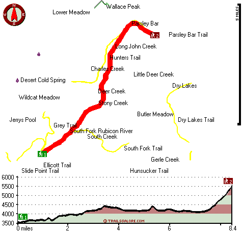
| |
|
| | You can't spend all your time indoors you need to get out once in a while, and Rubicon Trail in El Dorado County, California is a great spot to go. Rubicon Trail is a long trip away from Truckee-Grass Valley, but when you backcountry hike it you're always having a great time. Every California great outdoors trail is scenic in its own way. And keep in mind that there could be temporary safety restrictions in spot. This part of California has a good deal of available outdoors things to do. Being 16.8 miles long; it's considered a longer trek. Backcountry |
|
trekking here in California is a glorious way to spend some time. Through the months of summer highs here at Rubicon Trail get into the 90's. When the night sets in temperatures dip down into the 60's. The wintertime comes with highs in the 50's, and winter nights come with lows
| | in the 30's to Rubicon Trail. This is a neighborhood covered with lots of backcountry hiking trails. The trails of the Northern Sierra Nevada are a good way to explore these mountaintops. This is a backpacking and hiking trail that is quite long, so do pack enough food to last the whole trip. Sometimes this backpacking and hiking trail gets really dry, so make sure you check current conditions and fire restrictions with local forest authorities before you head out. Now, this is roughly a 2.5-day trek, so make sure you've got all your overnight gear packed. | |
|
Different parts of this hiking trail are at very different elevations, so keep in mind that you may need to dress differently at different elevations. Hiking trails are delightful and plentiful in California; Rubicon Trail in El Dorado County is one of them. The total elevation
difference for Rubicon Trail is 2,275 feet, and that is about average. The length of this trail is on the longer side with an average amount of climbing distance which makes this a very tough backcountry hiking trail for advanced backcountry trekkers looking for a perfect challenge.
Much precipitation falls at Rubicon Trail; January is the wettest month with most rain, and July is the month with the least moisture. This backpacking and hiking trail has two trailheads, so if you can get a ride from someone, you can hike it just one way.
Briefly about
the general area: Put some time aside to spend at Cold Spring while you're here at Rubicon Trail, and needless to say Stony Creek is a picturesque stream that is worth checking out. Having a fine time in the Northern Sierra Nevada is uncomplicated. Butler Meadow is a tremendous
site to stretch your legs a bit, and do stop by Deer Creek since you're here at Rubicon Trail. Drift down the rapids of Rubicon River in a kayak, and you can stay the night at Hell Hole Campground. Just can't get enough of Rubicon Trail. It's always wonderful to visit Bear
Springs. You'll need more than a day to discover everything Rubicon Trail has to offer, you can camp at McGuire Campground. But wait, there's more fun stuff to do in the Northern Sierra Nevada. Get yourself into a kayak and hit American River - South Fork. Lower Meadow is a wonderful location any time of year; a brilliant spot is Parsley Bar.
|
|
Location of Trailhead 1: Latitude 38.9563, Longitude -120.4842 - - Directions and Road Map
Location of Trailhead 2: Latitude 39.0272, Longitude -120.4171 - - Directions and Road Map

Trailhead 1 to Trailhead 2: Total hiking length = 8.4 miles Total climbing distance = 4.3 miles Difficulty : Difficult Casual Hiking Pace:
8 hours
Fast Hiking Pace:
4.5 hours
Trailhead 2 to Trailhead 1: Total hiking length = 8.4 miles Total climbing distance = 2.8 miles Difficulty : Difficult Casual Hiking Pace:
7 hours
Fast Hiking Pace:
4 hours
| | Trailhead 1 back to Trailhead 1: Total hiking length = 16.8 miles Total climbing distance = 7.1 miles Difficulty : Difficult Casual Hiking Pace:
2.5 days
Fast Hiking Pace:
1.5 days
Trailhead 2 back to Trailhead 2: Total hiking length = 16.8 miles Total climbing distance = 7.1 miles Difficulty : Difficult Casual Hiking Pace:
2.5 days
Fast Hiking Pace:
1.5 days
|
Total elevation difference: 2275 feet

Best Western Stagecoach Inn, Pollock Pines
|
17 miles away
Amid tall pine trees of the high Sierra Mountains, Best Western Stagecoach Inn is located in the town of Pollock Pines, 'Nature's Wonderland', off of US 50 between Sacramento and South Lake Tahoe. Her...
|
| |
Westhaven Inn Pollock Pines, Pollock Pines
|
17 miles away
Outside of Sacramento and situated on Highway 50, The Westhaven Inn offers convenience to shopping, golfing, hiking, boating, skiing, and other various outdoor activities. Only minutes to Sierra at T...
|
|
User input for Rubicon Trail, Northern Sierra Nevada, El Dorado County, California:

Outdoors Recreation Near Truckee-Grass Valley, California Very comprehensive list of a variety of outdoors recreation in the vicinity of Truckee-Grass Valley, California, the metro area neareast to Rubicon Trail. Find info on campgrounds, hiking trails, ski resorts, lakes, beaches, parks, whitewater and more.
More Hotels and Campgrounds Near Rubicon Trail, Northern Sierra Nevada, El Dorado County, California
| |
| |
 |
|
| These outdoors activities are available near Rubicon Trail. |
| | Trails Near Rubicon Trail:
 |
Hunters Trail, Placer
County
, 1 miles away, 5 hiking miles, 1957 feet elevation difference |
 |
South Fork Trail, El Dorado
County
, 2 miles away, 6.8 hiking miles, 1919 feet elevation difference |
 |
Parsley Bar Trail, Placer
County
, 3 miles away, 1.6 hiking miles, 1582 feet elevation difference |
 |
Grey Trail, Placer
County
, 3 miles away, 2.4 hiking miles, 2339 feet elevation difference |
 |
Hunsucker Trail, El Dorado
County
, 3 miles away, 1.9 hiking miles, 413 feet elevation difference |
 |
Dry Lakes Trail, El Dorado
County
, 3 miles away, 4.3 hiking miles, 879 feet elevation difference |
 |
Ellicott Trail, El Dorado
County
, 4 miles away, 1.3 hiking miles, 1591 feet elevation difference |
|
| | Whitewater Near Rubicon Trail:
 |
Rubicon River, Placer/ El Dorado County
County
, 10 miles away, Class V - 20.3 miles long (Ellicott Bridge to Ralston Afterbay) |
 |
American River - South Fork, El Dorado County
County
, 13 miles away, Class III-IV - 3.5 miles long (Riverton to Peavine Ridge Road) |
 |
American River - South Fork, El Dorado County
County
, 13 miles away, Class III-V - 9.6 miles long (Kyburz to Riverton) |
 |
American River - South Fork, El Dorado County
County
, 14 miles away, Class IV-V - 9.4 miles long (Peavine Ridge Road to Forebay Road) |
 |
Silver Creek - South Fork, El Dorado County
County
, 15 miles away, Class V+ - 2 miles long (Atherton Flat to Ice House Reservoir) |
|
| | Hotels Near Rubicon Trail:
 |
Best Western Stagecoach Inn, Pollock Pines
, 17 miles away |
 |
Westhaven Inn Pollock Pines, Pollock Pines
, 17 miles away |
 |
Squaw Valley Lodge, Squaw Valley
, 18 miles away |
 |
Village at Squaw Valley, Olympic Valley
, 18 miles away |
 |
Resort At Squaw Creek, Olympic Valley
, 20 miles away |
|
|
|
 |
|