California hiking trails - Rough and Ready Trail, Southern Cascade Range, Shasta County

   
  A lengthy journey separates Redding from Rough and Ready Trail, but backcountry trekking along this wilderness hiking trail is very cool. California is a nice site for outdoors folks. Spending too much time indoors got you down? No problem, Rough and Ready Trail in Shasta County, California is a brilliant choice. The warmest time of the year brings highs in the 80's to Rough and Ready Trail. Once the sun is down it plunges down to the 40's. During the wintertime highs are usually in the 40's with temperatures at Rough and Ready Trail dipping down into the
    20's during winter nights. Rough and Ready Trail has two trailheads which means you have the option of backpacking it one way if you have someone to pick you up at the other end. Hiking here in the Southern Cascade Range is a nice way to explore these summits. Rough and Ready Trail
has a total elevation difference of 343 feet which is lower than average. Backcountry trails are pleasant and plentiful in California, and one of these is Rough and Ready Trail in Shasta County. Rough and Ready Trail sees pretty high levels of rainfall; the month of January is the wettest with most of the rain while July is usually the driest month. If you happen to be in California, why not go backpacking, it is a wonderful idea. Every backpacking trail in California has its own unique splendor. Rough and Ready Trail is not that long but you should  
still bring some emergency supplies just in case something happens. This great outdoors hiking trail sometimes gets very dry, so make sure you check current conditions and fire restrictions with local forest authorities before you head out. This is one of many hiking trails in the surrounding neighborhood. The time needed for this backcountry hike is roughly 3.5 hours, but you never know stuff could go wrong and you could get stuck so be prepared for that. Being 3.8 miles long it's shorter than many backcountry trails. Rough and Ready Trail is a very short hiking trail with an average amount of climbing distance which makes it a great hiking trail for the average person looking for a great adventure. Please follow all local rules about fires and camping. There's not much difference in elevation along the backcountry trail, so you get pretty much the same conditions along the whole backcountry trail.

Briefly about the general area:
Coal Creek is a tremendous spot to stop at; you can stay the night at Deadlun Campground. Drift down the rapids of Pit River in a kayak.
Whohoo, so much amusing stuff in one place! The Southern Cascade Range is unbeatable! A spree to Bull Canyon is always fun. You'll need more than a day to explore everything Rough and Ready Trail has to offer, you can camp at Hawkins Landing Campground.

Location of Trailhead 1: Latitude 41.1046, Longitude -121.8734
- - Directions and Road Map

Location of Trailhead 2: Latitude 41.1031, Longitude -121.8798
- - Directions and Road Map


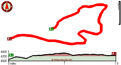
Trailhead 1 to Trailhead 2:
Total hiking length = 1.9 miles
Total climbing distance = .8 miles
Difficulty : Medium
Casual Hiking Pace: 1.5 hours
Fast Hiking Pace: 1 hours

Trailhead 2 to Trailhead 1:
Total hiking length = 1.9 miles
Total climbing distance = .7 miles
Difficulty : Medium
Casual Hiking Pace: 1.5 hours
Fast Hiking Pace: 1 hours
    Trailhead 1 back to Trailhead 1:
Total hiking length = 3.8 miles
Total climbing distance = 1.5 miles
Difficulty : Medium
Casual Hiking Pace: 3.5 hours
Fast Hiking Pace: 2 hours

Trailhead 2 back to Trailhead 2:
Total hiking length = 3.8 miles
Total climbing distance = 1.5 miles
Difficulty : Medium
Casual Hiking Pace: 3.5 hours
Fast Hiking Pace: 2 hours

Total elevation difference: 343 feet


Dunsmuir Travelodge, Dunsmuir
28 miles away
Located in the unbelievable scenery of Northern California, the Dunsmuir Travelodge is the ideal location to enjoy the splendors of the area. Conveniently located off Interstate 5, the Dunsmuir Travel...
  
Shastas Best Choice Inn, Dunsmuir
29 miles away
Shasta*s Best Choice Inn- come enjoy a peaceful cozy stay with breathtaking views of nature from your room. Experience the majestic view of Mt Shasta and the Siskiyou Mountains from our large picnic a...
User input for Rough and Ready Trail, Southern Cascade Range, Shasta County, California:

Submit Input:
Your Name:
Write or Paste Input here:

Upload picture:      Review Guidelines


Outdoors Recreation Near Redding, California
Very comprehensive list of a variety of outdoors recreation in the vicinity of Redding, California, the metro area neareast to Rough and Ready Trail. Find info on campgrounds, hiking trails, ski resorts, lakes, beaches, parks, whitewater and more.

Current weather conditions at Rough and Ready Trail, Southern Cascade Range, Shasta County, California
WXPort

Local climate location: MC CLOUD 14 miles away

Oak Tree Inn Dunsmuir, Dunsmuir
29 miles away
With extra-quiet guest rooms and light-proof draperies, the new Oak Tree Inn opened in January 2007 in Dunsmuir -- Home of the Best Water on Earth. This 100-percent non-smoking hotel is conveniently ...

Strawberry Valley Inn, Mount Shasta
32 miles away
Set in a picturesque storybook setting of stone rock siding, beautiful trees and flowers and with a backdrop of Mount Shasta, our cozy hotel is perfectly locating in the town center. It is close to wo...

More Hotels and Campgrounds Near Rough and Ready Trail, Southern Cascade Range, Shasta County, California

OTHER_INFO
  Southern Cascade Range Campgrounds
Complete list of all the campgrounds in the Southern Cascade Range.

Southern Cascade Range Outdoors Info
Complete outdoors info for the Southern Cascade Range.

California Hiking Trails
Complete list of all hiking trails in California

Books about hiking trails in California
List of books available on Amazon.com about hiking trails in California.

California Outdoors Index
This is a very comprehensive index of outdoors activities in the great state of California.


TOPO
High quality water resistant topo map of Rough and Ready Trail, Southern Cascade Range, Shasta County, California.

OUTDOORS_GUIDE
These outdoors activities are available near Rough and Ready Trail.
 Trails Near Rough and Ready Trail:
Coal Mine Trail, Shasta County , 2 miles away,  10.6 hiking miles, 3603 feet elevation difference
Pacific Crest Trail - section 17, County , 3 miles away, 85.8 hiking miles, 5083 feet elevation difference
Angel Meadow Trail, Siskiyou County , 7 miles away, 3.1 hiking miles, 1415 feet elevation difference
Nelson Flat Trail, Shasta County , 8 miles away,  4.6 hiking miles, 697 feet elevation difference
Cone Point Trail, Shasta County , 8 miles away, 3.2 hiking miles, 633 feet elevation difference
 Camp Grounds Near Rough and Ready Trail:
Deadlun Campground, Shasta County, 8 miles away
Hawkins Landing Campground, Shasta County, 8 miles away
Deep Creek Campground, Shasta County, 8 miles away
Fowlers Campground, Siskiyou County, 13 miles away
Circle Seven Guest Ranch, Mccloud, 13 miles away
 Whitewater Near Rough and Ready Trail:
Pit River, Shasta County County , 7 miles away, Class IV - 9 miles long (Pit 5 Dam to Pit 5 Powerhouse)
Pit River, Shasta County County , 8 miles away, Class IV - 7 miles long (Pit 4 Dam to Pit 4 Powerhouse)
 National Parks Near Rough and Ready Trail:
Lassen Volcanic National Park, Mineral - CA , 44 miles away
Lava Beds National Monument, Tulelake - CA , 52 miles away
Whiskeytown National Recreation Area, Whiskeytown - CA , 55 miles away
 Hotels Near Rough and Ready Trail:
Dunsmuir Travelodge, Dunsmuir , 28 miles away
Shastas Best Choice Inn, Dunsmuir , 29 miles away
Oak Tree Inn Dunsmuir, Dunsmuir , 29 miles away
Strawberry Valley Inn, Mount Shasta , 32 miles away
Best Western Tree House Motor Inn, Mount Shasta , 33 miles away

Outdoors related information copyright © Stratus-Pikpuk, Inc. - Detailed hotel information copyright © Interactive Hotel Solutions