| |
|
| | Trekking here in California is the pleasant thing to do. There are so many pleasant wilderness trails for hiking in California, and Romero Trail is one of them, and it's in Santa Barbara County. Every California wilderness trail has something unique to offer. The wonderful backcountry trails of the Sierra Madre are the best way to enjoy these peaks. This region does get very dry sometimes, so make sure you check current conditions and fire restrictions with local forest authorities before you head out. This is an area covered with lots of hiking and backpacking |
|
trails. Romero Trail is situated a quite lengthy drive from Santa Barbara-Santa Maria-Goleta, but it is one of many fine hiking trails in this region. This backcountry trail is a very short backcountry trail with an average amount of climbing distance which makes this hiking and
| | backpacking trail pleasant for the average hiker looking for an exciting adventure. You spend the whole hike in roughly the same elevation zone which means the conditions are about the same from start to finish. This wilderness trail has only one trailhead, so in and out is the way to hike it normally. You should count on this walk taking about .5 hours, but you never know stuff could go wrong and you could get stuck so be prepared for that. During the warm months here at Romero Trail, high temperatures generally get into the 90's. For the period of the | |
|
moonlight hours it's generally in the 50's. For the period of the winter highs are in the 60's, and nighttime lows in the 30's for Romero Trail. With its .8 miles of walking distance it's a shorter type hike. Romero Trail is not that long but you should still bring some emergency
supplies just in case something happens. The total elevation difference for this wilderness trail is 579 feet, and that is lower than average. If you are in California during backcountry trekking season you have to go backcountry trekking. Time to get out, and breathe some fresh
air, and Romero Trail in Santa Barbara County, California is just the place. And keep in mind that there could be temporary safety restrictions in location. Romero Trail is typically a rather dried up location; through the month of February you get the most rain around here while
July is the month with the least amount of precipitation.
Briefly about the general area: Life's too short to enjoy all the cool things in the Sierra Madre. A trip to Channel Islands National Park is worthwhile; East Beach is a pretty beach to pop by. Camping is available
at Blue Canyon Campground. Do visit Pendola Debris Dam since you're here at Romero Trail, and if you came for an overnight stay Upper Blue Canyon Campground is a fine location to camp.
|
|
Location of Trailhead: Latitude 34.4803, Longitude -119.588 - - Directions and Road Map
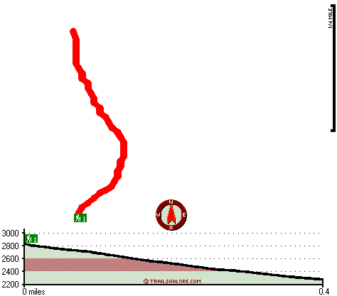
Total in and out hiking length = .8 miles
Total climbing distance = .3 miles
Difficulty : Medium
Casual Hiking Pace:
.5 hours
Fast Hiking Pace:
.5 hours
Total elevation difference: 579 feet

Inn on Summer Hill, Summerland
|
4 miles away
The Inn is nestled in the rolling foothills of Santa Barbara, in the charming seaside village of Summerland. Each day begins with a delicious gourmet breakfast in the dinning room. Specialty hors d-oe...
|
| |
Montecito Inn, Santa Barbara
|
5 miles away
The Montecito Inn was built in 1928 by screen legend Charlie Chaplin as an escape to paradise for his closest friends. Enriched with influences reminiscent of early Santa Barbara, newly designed guest...
|
|
User input for Romero Trail, Sierra Madre, Santa Barbara County, California:

Outdoors Recreation Near Santa Barbara-Santa Maria-Goleta, California Very comprehensive list of a variety of outdoors recreation in the vicinity of Santa Barbara-Santa Maria-Goleta, California, the metro area neareast to Romero Trail. Find info on campgrounds, hiking trails, ski resorts, lakes, beaches, parks, whitewater and more.
|
Current weather conditions at Romero Trail, Sierra Madre, Santa Barbara County, California

Local climate location: CACHUMA LAKE 7 miles away

           
| |
Coast Village Inn, Santa Barbara
|
5 miles away
The Coast Village Inn is located in Santa Barbera, CA, nestled between the mountains and the sea in the heart of the lush coastal community of Montecito. Pristine beaches, unique shops and boutiques, ...
|
Sandyland Reef Inn, Carpinteria
|
6 miles away
Reasonably price with beautifully appointed rooms. Sandyland Reef present with the guest an adequate choice of king size rooms, double beds rooms. Sandyland have a great pool and a jacuzzi hot pool fo...
|
|
More Hotels and Campgrounds Near Romero Trail, Sierra Madre, Santa Barbara County, California
| |
| |
 |
|
| These outdoors activities are available near Romero Trail. |
| | Trails Near Romero Trail:
 |
Blue Canyon Trail, Santa Barbara
County
, 0 miles away, 4.7 hiking miles, 741 feet elevation difference |
 |
San Ysidro Trail, Santa Barbara
County
, 3 miles away, 3.4 hiking miles, 3463 feet elevation difference |
 |
Cold Spring Trail, Santa Barbara
County
, 3 miles away, 14.4 hiking miles, 2741 feet elevation difference |
 |
Franklin Trail, Santa Barbara
County
, 6 miles away, 8 hiking miles, 2209 feet elevation difference |
 |
Pie Canyon Trail, Santa Barbara
County
, 6 miles away, 3.6 hiking miles, 1780 feet elevation difference |
 |
Mono Alamar Trail, Santa Barbara
County
, 7 miles away, 9.4 hiking miles, 1332 feet elevation difference |
 |
Agua Caliente Trail, Santa Barbara
County
, 7 miles away, 17 hiking miles, 2537 feet elevation difference |
|
| | National Parks Near Romero Trail:
 |
Channel Islands National Park, Ventura - CA
, 23 miles away |
 |
Santa Monica Mountains National Recreation Area, Thousand Oaks - CA
, 52 miles away |
|
| | Hotels Near Romero Trail:
 |
Inn on Summer Hill, Summerland
, 4 miles away |
 |
Montecito Inn, Santa Barbara
, 5 miles away |
 |
Coast Village Inn, Santa Barbara
, 5 miles away |
 |
Sandyland Reef Inn, Carpinteria
, 6 miles away |
 |
Best Western Carpinteria Inn, Carpinteria
, 6 miles away |
|
|
|
 |
|