California hiking trails - Rincon Trail, Santa Ynez Mountains, Santa Barbara County

   
  Rincon Trail is a backpacking and hiking trail quite far from Oxnard-Thousand Oaks-Ventura, but backcountry backpacking it is always cool. There are so many good great outdoors trails for backcountry hiking in California, and Rincon Trail is one of them, and it's in Santa Barbara County. Can’t wait to get out in the great outdoors, Rincon Trail in Santa Barbara County, California is the great outdoors at its best. Every California great outdoors trail is well worth a walk. This great outdoors hiking trail has a total elevation difference of 4,654 feet which
    is higher than average. Of course, this is an overnight backcountry trek, 1.5 days normally, so make sure you've got all your overnight gear packed. Rincon Trail is quite long, so do pack enough food to last the whole trip. Sometimes this great outdoors hiking trail gets really
dry, so don’t forget to check for any current fire restrictions before you go. California has lots of outdoors pursuits. Around Rincon Trail you don’t get a lot of precipitation; most of the rain falls throughout February while July is the month with the least amount of precipitation. Through the warm days of summer at Rincon Trail temperatures are mostly in the 90's while overnight lows are typically in the 50's. The wintertime brings highs down to the 60's, and during the dark hours in the wintertime at Rincon Trail temperatures sink to the 30's. Trekking  
here in California is always a fun thing to do. Some parts of this backpacking and hiking trail are much higher up than other parts of the backpacking and hiking trail, so keep in mind that you may need to dress differently at different elevations. Don’t forget to check for any current restrictions or closures before you go. Rincon Trail is many miles long with an average amount of climbing distance which makes this a very tough backpacking trail for advanced backcountry hikers looking for a great challenge. Being 11.6 miles long; it's considered a longer walk. Rincon Trail is a one trailhead great outdoors hiking trail, so you'll be backcountry hiking it in and back out. This is a region covered with lots of backpacking trails. Hiking trails like this one here in the Santa Ynez Mountains are a really good way to spend quality time in the fresh air.

Briefly about the general area:
You completely must like the Santa Ynez Mountains. Camping at Murietta Campground is always a splendid experience; there's some flowing water close by, Catharina Creek is a stream you can stop at while here.
This is no site for people who don’t like to have a good time. Billiard Flats is a perfect location to check out; during your trip here you'll meet some people from Oxnard-Thousand Oaks-Ventura for sure. Near Rincon Trail you discover nice places like Murietta Divide, and Eldorado Creek is one of the streams close by that might be worth going to. These mountains rock, just check out all the amusing stuff to do in the Santa Ynez Mountains. Rincon Point is in the vicinity and always nice to have a look at, and a tour to Channel Islands National Park is worthwhile.
Hit the beach if you want, Oil Piers Beach is practically right here, and if you came to camp Alder Creek Campground is a great site to do that.

Location of Trailhead: Latitude 34.4112, Longitude -119.4482
- - Directions and Road Map

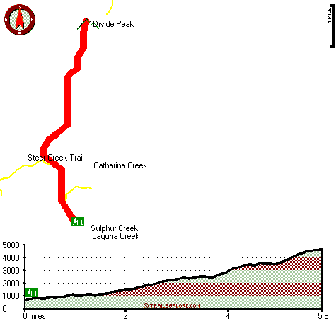
Total in and out hiking length = 11.6 miles

Total climbing distance = 5.2 miles

Difficulty : Difficult

Casual Hiking Pace: 1.5 days

Fast Hiking Pace: 7 hours

Total elevation difference: 4654 feet


Holiday Inn Express Hotel & Suites Carpinteria, Carpinteria
5 miles away
The Holiday Inn Express Hotel & Suites Carpinteria welcomes you! Our warm coastal community has one of the most beautiful and highly rated beaches in the country. Whether all day with the family or af...
  
Best Western Carpinteria Inn, Carpinteria
6 miles away
Stay at this Carpinteria, California hotel and enjoy the scenic countryside and the world's safest beaches. The Best Western Carpinteria Inn is conveniently located with easy access to key area attr...
User input for Rincon Trail, Santa Ynez Mountains, Santa Barbara County, California:

Submit Input:
Your Name:
Write or Paste Input here:

Upload picture:      Review Guidelines


Outdoors Recreation Near Oxnard-Thousand Oaks-Ventura, California
Very comprehensive list of a variety of outdoors recreation in the vicinity of Oxnard-Thousand Oaks-Ventura, California, the metro area neareast to Rincon Trail. Find info on campgrounds, hiking trails, ski resorts, lakes, beaches, parks, whitewater and more.

Current weather conditions at Rincon Trail, Santa Ynez Mountains, Santa Barbara County, California
WXPort

Local climate location: CACHUMA LAKE 11 miles away

Sandyland Reef Inn, Carpinteria
6 miles away
Located conveniently close to the beach and visible from Freeway 101, Sandyland Reef Inn is beautifully built with Santa Barbara charm. Just 1 mile from downtown Carpinteria and 10 miles South of Sant...

Inn on Summer Hill, Summerland
10 miles away
The Inn is nestled in the rolling foothills of Santa Barbara, in the charming seaside village of Summerland. Each day begins with a delicious gourmet breakfast in the dinning room. Specialty hors d-oe...

More Hotels and Campgrounds Near Rincon Trail, Santa Ynez Mountains, Santa Barbara County, California

OTHER_INFO
  Santa Ynez Mountains Campgrounds
Complete list of all the campgrounds in the Santa Ynez Mountains.

Santa Ynez Mountains Outdoors Info
Complete outdoors info for the Santa Ynez Mountains.

California Hiking Trails
Complete list of all hiking trails in California

Books about hiking trails in California
List of books available on Amazon.com about hiking trails in California.

California Outdoors Index
This is a very comprehensive index of outdoors activities in the great state of California.


TOPO
High quality water resistant topo map of Rincon Trail, Santa Ynez Mountains, Santa Barbara County, California.

OUTDOORS_GUIDE
These outdoors activities are available near Rincon Trail.
 Trails Near Rincon Trail:
Steer Creek Trail, Santa Barbara County , 1 miles away,  7.8 hiking miles, 1010 feet elevation difference
Monte Arido Trail, Ventura County , 2 miles away,  1.8 hiking miles, 1244 feet elevation difference
Franklin Trail, Santa Barbara County , 4 miles away,  8 hiking miles, 2209 feet elevation difference
Ocean View Trail, Ventura County , 4 miles away,  8.8 hiking miles, 1017 feet elevation difference
Coyote Trail, Ventura County , 5 miles away, 3.2 hiking miles, 2072 feet elevation difference
Agua Caliente Trail, Santa Barbara County , 9 miles away,  17 hiking miles, 2537 feet elevation difference
Blue Canyon Trail, Santa Barbara County , 10 miles away, 4.7 hiking miles, 741 feet elevation difference
 Camp Grounds Near Rincon Trail:
Alder Creek Campground, Santa Barbara County, 4 miles away
Murietta Campground, Ventura County, 5 miles away
Ventura Oaks RV Park, Ojai, 5 miles away
Carpinteria Camper Park, Carpinteria, 6 miles away
Juncal Campground, Santa Barbara County, 7 miles away
 Beaches Near Rincon Trail:
Oil Piers Beach, Ventura County , 6 miles away
 National Parks Near Rincon Trail:
Channel Islands National Park, Ventura - CA , 14 miles away
Santa Monica Mountains National Recreation Area, Thousand Oaks - CA , 42 miles away
 Hotels Near Rincon Trail:
Holiday Inn Express Hotel & Suites Carpinteria, Carpinteria , 5 miles away
Best Western Carpinteria Inn, Carpinteria , 6 miles away
Sandyland Reef Inn, Carpinteria , 6 miles away
Inn on Summer Hill, Summerland , 10 miles away
Oakridge Inn, Ojai , 11 miles away
 Lakes Near Rincon Trail
Carpinteria Reservoir, Santa Barbara County , 3 miles away
Jameson Lake, Santa Barbara County , 4 miles away

Outdoors related information copyright © Stratus-Pikpuk, Inc. - Detailed hotel information copyright © Interactive Hotel Solutions