| |
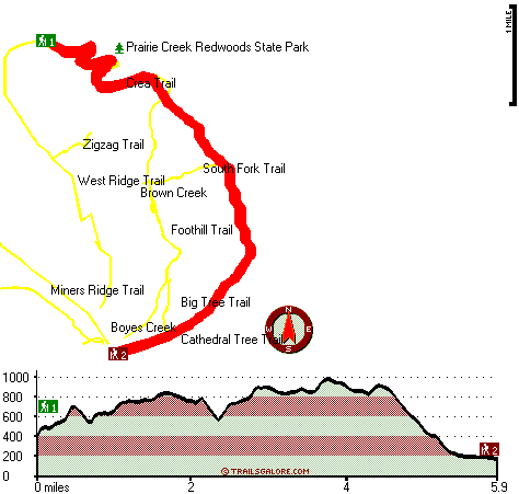
The total elevation difference for this backcountry trail is 977 feet, and that is lower than average. This backpacking trail sometimes gets very dry, so do check for current fire restrictions before you go if you plan to bring a stove or make a camp fire. There's not much difference in elevation along Rhododendron Trail, so you get pretty much the same conditions along the whole hiking and backpacking trail. This backcountry trail has two trailheads which means you have the option of backcountry hiking it one way if you have someone to pick you up at the other end. Rhododendron Trail is 11.8 miles long; it's longer than many hiking and backpacking trails. This is a long backpacking trail, so don't forget to pack enough supplies. Now, this is roughly a 2-day backcountry hike, so it's an outstanding thing if your backpack is big enough to do the job.
|
Trailhead 1 to Trailhead 2:
Total hiking length = 5.9 miles
Total climbing distance = 2.2 miles
Difficulty : Medium
Casual Hiking Pace:
5 hours
Fast Hiking Pace:
3 hours
Trailhead 2 to Trailhead 1:
Total hiking length = 5.9 miles
Total climbing distance = 3 miles
Difficulty : Medium
Casual Hiking Pace:
5.5 hours
Fast Hiking Pace:
3 hours
| | Trailhead 1 back to Trailhead 1:
Total hiking length = 11.8 miles
Total climbing distance = 5.2 miles
Difficulty : Difficult
Casual Hiking Pace:
2 days
Fast Hiking Pace:
7 hours
Trailhead 2 back to Trailhead 2:
Total hiking length = 11.8 miles
Total climbing distance = 5.2 miles
Difficulty : Difficult
Casual Hiking Pace:
2 days
Fast Hiking Pace:
7 hours
|
Total elevation difference: 977 feet
|


