| |
|
| | There are plenty of hiking trails in California; each one of them has something unique to offer. We all need to get out in the fresh air once in a while, and Ranger Peak Trail in Santa Barbara County, California is a glorious place to go. There are many splendid hiking trails in California, and Ranger Peak Trail in Santa Barbara County is one of them. This is a long hiking and backpacking trail, so don't forget to pack enough supplies. Being 7.6 miles long it's an average length trail. And keep in mind that there could be temporary safety restrictions |
|
in place. At parts of the year this neighborhood sees very little rain, so don’t forget to check for any current fire restrictions before you go. You should count on this walk taking about 7 hours, but you never know stuff could go wrong and you could get stuck so be prepared for
| | that. Ranger Peak Trail is a normal length backcountry trail having an average number of uphill miles which makes it a splendid trail for experienced backcountry hikers in delightful shape. Backcountry hiking trails like this one here in the Sierra Madre are a very delightful way to see these peaks. The warmest time of the year brings highs in the 80's to Ranger Peak Trail, and the nighttime is a tad chillier of course, typically in the 50's. Highs during the wintertime are typically in the 60's with temperatures at Ranger Peak Trail dipping down into the | |
|
30's during winter nights. This is just one of a large number of trails in this area. This trail goes through some very different elevations which of course means you need to be prepared for different conditions on different parts of the trail. Ranger Peak Trail gets very little
rainfall; the wettest month of the year is ordinarily February, that's the one that rains the most, and July is the month with the least moisture. Ranger Peak Trail has two trailheads, so backcountry hiking it one way is an option if you can arrange for a ride back. It's a long
drive from Santa Barbara-Santa Maria-Goleta to Ranger Peak Trail, but great outdoors hiking trails like these are wonderful. California has lots of outdoors endeavors. Here in California hiking is so much fun. The total elevation difference for this great outdoors hiking trail
is 2,190 feet which is about average.
Briefly about the general area: Having a splendid time in the Sierra Madre is painless. Davy Brown Campground is a good campground nearby, and why not take a little visit to East Fork Fish Creek while you're here. If you came for
an overnight stay Lost Valley Campground is a delightful site to camp; Soldiers Home Spring is always fun to check out. There are plenty of folks from Santa Barbara-Santa Maria-Goleta here at Ranger Peak Trail, and a short spree to Chicken Springs is always worthwhile. There's
a tremendous forest near Ranger Peak Trail called East Pinery, and Lion Canyon is close at hand, and is a splendid site. Yep, outdoors amusing stuff to do are beyond doubt bountiful here at Ranger Peak Trail.
|
|
Location of Trailhead 1: Latitude 34.6813, Longitude -119.9183 - - Directions and Road Map
Location of Trailhead 2: Latitude 34.7204, Longitude -119.9555 - - Directions and Road Map

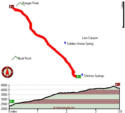
Trailhead 1 to Trailhead 2: Total hiking length = 3.8 miles Total climbing distance = 2.8 miles Difficulty : Difficult Casual Hiking Pace:
4 hours
Fast Hiking Pace:
2.5 hours
Trailhead 2 to Trailhead 1: Total hiking length = 3.8 miles Total climbing distance = .5 miles Difficulty : Easy Casual Hiking Pace:
2.5 hours
Fast Hiking Pace:
1.5 hours
| | Trailhead 1 back to Trailhead 1: Total hiking length = 7.6 miles Total climbing distance = 3.3 miles Difficulty : Difficult Casual Hiking Pace:
7 hours
Fast Hiking Pace:
4.5 hours
Trailhead 2 back to Trailhead 2: Total hiking length = 7.6 miles Total climbing distance = 3.3 miles Difficulty : Difficult Casual Hiking Pace:
7 hours
Fast Hiking Pace:
4.5 hours
|
Total elevation difference: 2190 feet

Santa Ynez Inn, Santa Ynez
|
11 miles away
Located in the heart of Santa Barbara County wine country, our wine country getaway awaits in individually decorated rooms and junior suites. Accommodations feature unique antiques, luxury linens, gas...
|
| |
El Capitan Canyon, Santa Barbara
|
15 miles away
Nestled between the Pacific Ocean and the Santa Ynez mountains lies El Capitan Ranch, an incredible beach side canyon resort located 15 minutes North of downtown Santa Barbara. Built in 2001, El Capit...
|
|
User input for Ranger Peak Trail, Sierra Madre, Santa Barbara County, California:

Outdoors Recreation Near Santa Barbara-Santa Maria-Goleta, California Very comprehensive list of a variety of outdoors recreation in the vicinity of Santa Barbara-Santa Maria-Goleta, California, the metro area neareast to Ranger Peak Trail. Find info on campgrounds, hiking trails, ski resorts, lakes, beaches, parks, whitewater and more.
More Hotels and Campgrounds Near Ranger Peak Trail, Sierra Madre, Santa Barbara County, California
| |
| |
 |
|
| These outdoors activities are available near Ranger Peak Trail. |
| | Trails Near Ranger Peak Trail:
 |
Potrero Canyon Trail, Santa Barbara
County
, 5 miles away, 7.8 hiking miles, 2012 feet elevation difference |
 |
Hurricane Deck Trail, Santa Barbara
County
, 7 miles away, 36.2 hiking miles, 3358 feet elevation difference |
 |
Rattlesnake Trail, Santa Barbara
County
, 10 miles away, 1.6 hiking miles, 207 feet elevation difference |
 |
Manzana Trail, Santa Barbara
County
, 10 miles away, 18.6 hiking miles, 3096 feet elevation difference |
 |
Gato Trail, Santa Barbara
County
, 11 miles away, 6.6 hiking miles, 3037 feet elevation difference |
 |
Santa Cruz Trail, Santa Barbara
County
, 12 miles away, 9.9 hiking miles, 2660 feet elevation difference |
 |
Jackson Trail, Santa Barbara
County
, 13 miles away, 7.4 hiking miles, 3327 feet elevation difference |
|
| | Hotels Near Ranger Peak Trail:
 |
Santa Ynez Inn, Santa Ynez
, 11 miles away |
 |
El Capitan Canyon, Santa Barbara
, 15 miles away |
 |
Svendsgaard's Danish Lodge, Solvang
, 15 miles away |
 |
Bacara Resort Spa, Santa Barbara
, 15 miles away |
 |
Royal Scandinavian Inn, Solvang
, 15 miles away |
|
|
|
 |
|