| |
|
| | There are hiking and backpacking trails all over California; one of these is High Desert National Recreational Trail in Los Angeles County. Trekking in California is a good idea. Spending too much time indoors got you down? No problem, High Desert National Recreational Trail in Los Angeles County, California is a really good place to spend some time. High Desert National Recreational Trail is situated a pretty long journey from Los Angeles-Long Beach-Santa Ana, but hiking is such an enjoyable thing to do, and this is a perfect place to do that. Different |
|
parts of High Desert National Recreational Trail are at very different elevations, and that means that some parts of the wilderness trail could be very different from other parts of it. Every California hiking and backpacking trail is well worth a backcountry hike. Keep in mind
| | that this is a long wilderness hiking trail, so make sure you bring plenty of supplies. Summertime at High Desert National Recreational Trail comes with high temperatures in the 90's while night lows are regularly in the 60's. Through the wintertime highs are regularly in the 50's while High Desert National Recreational Trail night low temperatures throughout the wintertime are in the 30's. High Desert National Recreational Trail has a total elevation difference of 3,046 feet, and that is higher than average. Around High Desert National Recreational Trail | |
|
you don’t get a lot of rain; February is when you get the most rain here, and July is when it's the driest. California is a brilliant place for outdoors people. Being 38.2 miles long; it's considered a longer backcountry hike. This is a two-ended hiking and backpacking trail with
two trailheads, so if you can get a ride from someone, you can hike it just one way. And keep in mind that there could be temporary safety restrictions in place. The length of this backpacking trail is on the longer side with an average amount of climbing distance which makes it
a splendid wilderness hiking trail for experienced walkers in great shape. At parts of the year this area sees very little rain, so don’t forget to check for any current fire restrictions before you go. Of course, this is an overnight trek, 6 days normally, so make sure you've
got all your overnight gear packed. This is a neighborhood covered with lots of wilderness hiking trails.
Briefly about the general area: A short visit to Reed Spring is always worthwhile, and Devils Punchbowl is a delightful site any time of year. A fine forest close
to High Desert National Recreational Trail is San Dimas Experimental Forest. Places like Yerba Santa Amphitheater are wonderful to go to, and there's some flowing water close by, Watkins Creek is a stream you can check out during your stay. Near High Desert National Recreational
Trail you come across great places like Holcomb Canyon. You'll need more than a day to look at everything High Desert National Recreational Trail has to offer, you can camp at Big Rock Creek Camp. A tour to High Desert National Recreational Trail wouldn't be complete without taking
a look at Cortelyou Spring. There's so much to do here at High Desert National Recreational Trail that you need to camp here for a while, Little Jimmy Campground is a splendid place for that. Having a splendid time at High Desert National Recreational Trail is trouble-free. South Fork Big Rock Creek flows through this neighborhood, and taking a little visit to nearby Newman Point is a pleasant idea.
|
|
Location of Trailhead 1: Latitude 34.3449, Longitude -117.9098 - - Directions and Road Map
Location of Trailhead 2: Latitude 34.3739, Longitude -117.7567 - - Directions and Road Map

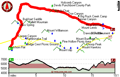
Trailhead 1 to Trailhead 2: Total hiking length = 19.1 miles Total climbing distance = 8.6 miles Difficulty : Difficult Casual Hiking Pace:
3 days
Fast Hiking Pace:
1.5 days
Trailhead 2 to Trailhead 1: Total hiking length = 19.1 miles Total climbing distance = 9.9 miles Difficulty : Difficult Casual Hiking Pace:
3 days
Fast Hiking Pace:
1.5 days
| | Trailhead 1 back to Trailhead 1: Total hiking length = 38.2 miles Total climbing distance = 18.5 miles Difficulty : Difficult Casual Hiking Pace:
6 days
Fast Hiking Pace:
4 days
Trailhead 2 back to Trailhead 2: Total hiking length = 38.2 miles Total climbing distance = 18.5 miles Difficulty : Difficult Casual Hiking Pace:
6 days
Fast Hiking Pace:
4 days
|
Total elevation difference: 3046 feet

Americas Best Value Inn, Azusa
|
15 miles away
Welcome to the Americas Best Value Inn of Azusa. We are located three miles north of Interstate-10 and just two blocks south of the 210 Freeway. We have a Family Restaurant on-site, and we serve a fre...
|
| |
Best Western Route 66 Glendora Inn, Glendora
|
16 miles away
Welcome to Best Western Route 66 Glendora Inn! This beautifully and newly constructed property is nestled in the Pride of the Foothills, Glendora, California and located on historic Route 66. We offe...
|
|
User input for High Desert National Recreational Trail, Los Angeles County, California:

Outdoors Recreation Near Los Angeles-Long Beach-Santa Ana, California Very comprehensive list of a variety of outdoors recreation in the vicinity of Los Angeles-Long Beach-Santa Ana, California, the metro area neareast to High Desert National Recreational Trail. Find info on campgrounds, hiking trails, ski resorts, lakes, beaches, parks, whitewater and more.
More Hotels and Campgrounds Near High Desert National Recreational Trail, Los Angeles County, California
| |
| |
 |
|
| These outdoors activities are available near High Desert National Recreational Trail. |
| | Trails Near High Desert National Recreational Trail:
 |
Rattlesnake Trail, Los Angeles
County
, 3 miles away, 6.4 hiking miles, 1110 feet elevation difference |
 |
Bear Creek Trail, Los Angeles
County
, 7 miles away, 8.7 hiking miles, 2934 feet elevation difference |
 |
Heaton Flat Trail, Los Angeles
County
, 12 miles away, 13.3 hiking miles, 3275 feet elevation difference |
 |
Allison Trail, Los Angeles
County
, 12 miles away, 17 hiking miles, 5495 feet elevation difference |
 |
Gabrielino National Scenic Trail, Los Angeles
County
, 15 miles away, 19.9 hiking miles, 3843 feet elevation difference |
 |
Fern Canyon Trail, Los Angeles
County
, 16 miles away, 13 hiking miles, 455 feet elevation difference |
 |
Santa Anita Trail, Los Angeles
County
, 16 miles away, 4.2 hiking miles, 2891 feet elevation difference |
|
| | Whitewater Near High Desert National Recreational Trail:
 |
Piru Creek, Ventura County
County
, 63 miles away, Class II - 4 miles long (Lake Piru to Santa Clara River) |
 |
Piru Creek, Los Angeles / Ventura County
County
, 63 miles away, Class IV - 15 miles long (Pyramid Lake to Lake Piru) |
 |
Santa Margarita River, San Diego County
County
, 71 miles away, Class IV(V) - 9 miles long (Murrieta Creek to Sandia Creek Road) |
|
| | Hotels Near High Desert National Recreational Trail:
 |
Americas Best Value Inn, Azusa
, 15 miles away |
 |
Best Western Route 66 Glendora Inn, Glendora
, 16 miles away |
 |
Rodeway Inn & Suites, Pomona
, 16 miles away |
 |
Super 8 Azusa, Azusa
, 16 miles away |
 |
Rodeway Inn Azusa, Azusa
, 16 miles away |
|
|
|
 |
|