California hiking trails - Pothole Trail, Sierra Madre, Ventura County

   
  Here in California trekking is so much fun. There are plenty of wilderness trails in California; each one of them is worth trekking. Gotta get out of the city man, and Pothole Trail in Ventura County, California is just the site. A long drive separates Oxnard-Thousand Oaks-Ventura from Pothole Trail, but it is one of many great backpacking trails in this vicinity. This hiking and backpacking trail has only one trailhead, so you're looking at an in and out trek. California is an excellent place for backcountry walkers. There are so many trails in this area.
    Pothole Trail has a total elevation difference of 2,168 feet which is an average number. At Pothole Trail during the summertime highs are in the 80's. All through the dark hours of summer temperatures sink down into the 60's. The winter comes with highs in the 40's, and winter
nights come with lows in the 30's to Pothole Trail. This backcountry hike should take you about 1.5 days, so it's a wonderful thing if your backpack is big enough to do the job. And keep in mind that there could be temporary safety restrictions in place. Trails like this one here in the Sierra Madre are an excellent way to explore these highlands. This is a long backpacking and hiking trail, so make sure you bring plenty of supplies. Sometimes this backpacking and hiking trail gets really dry, so don’t forget to check for any current fire restrictions before  
you go. This backpacking trail is a backpacking trail of glorious length with an average amount of climbing distance which makes it an outstanding trail for experienced backcountry walkers in nice shape. There are many great wilderness trails in California, and among these are Pothole Trail in Ventura County. Being 10.6 miles long; it's a long backpacking and hiking trail. Pothole Trail is pretty dehydrated generally; the month of February is the wettest with most of the rain while July is the month with the least amount of precipitation. Different parts of this backpacking and hiking trail are at very different elevations, and that means that some parts of the backpacking and hiking trail could be very different from other parts of it.

Briefly about the general area:
And if you're still looking for more outdoors cool things just keep reading. While staying at Pothole Trail you could always discover Sharps Canyon, and camping is available at Lake Piru. So many amusing things in the Sierra Madre, just phenomenal. A visit to Pothole Spring will fill your spirit with good feelings; do set aside some time for Devils Potrero while you're here at Pothole Trail.
Take a side tour to Michael Creek; there's whitewater on Piru Creek for all you adrenaline kick people. And that's not all there is to do here in the Sierra Madre. Get your heart beating on the good whitewater of Piru Creek, and do put some time aside to spend at Juan Fernandez Spring while you're here at Pothole Trail.
Visit Agua Blanca Creek if you're here at Pothole Trail, and you must certainly dedicate some time to The Pothole if you're here at Pothole Trail. Santa Monica Mountains National Recreation Area is a very tremendous location to check out right next door to Pothole Trail, and a splendid place to camp here at Pothole Trail is Blue Point Campground.

Location of Trailhead: Latitude 34.5134, Longitude -118.762
- - Directions and Road Map

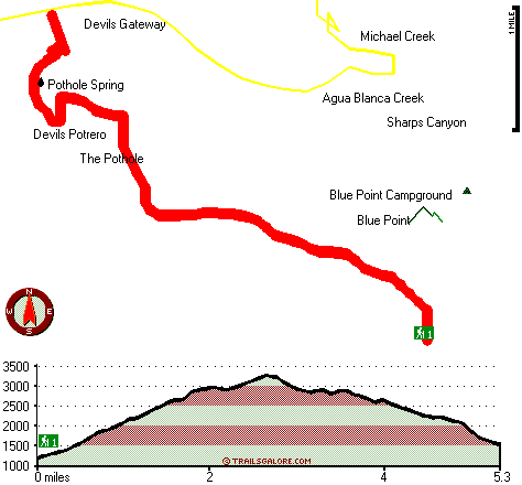
Total in and out hiking length = 10.6 miles

Total climbing distance = 4.9 miles

Difficulty : Difficult

Casual Hiking Pace: 1.5 days

Fast Hiking Pace: 6.5 hours

Total elevation difference: 2168 feet


Rodeway Inn Magic Mountain Area, Castaic
11 miles away
The Rodeway Inn Magic Mountain Area is conveniently located just five minutes from Six Flags Magic Mountain and minutes from Castaic Lake, where visitors will enjoy swimming, boating and fishing. Gues...
  
Days Inn Castaic Six Flags Magic Mountain, Castaic
11 miles away
Welcome to the Days Inn Castaic, CA. We are conveniently located off I-5 in close proximity to Six Flags Magic Mountain, Castaic. Whether on business or pleasure our clean, quiet, safe property is sur...
User input for Pothole Trail, Sierra Madre, Ventura County, California:

Submit Input:
Your Name:
Write or Paste Input here:

Upload picture:      Review Guidelines


Outdoors Recreation Near Oxnard-Thousand Oaks-Ventura, California
Very comprehensive list of a variety of outdoors recreation in the vicinity of Oxnard-Thousand Oaks-Ventura, California, the metro area neareast to Pothole Trail. Find info on campgrounds, hiking trails, ski resorts, lakes, beaches, parks, whitewater and more.

Current weather conditions at Pothole Trail, Sierra Madre, Ventura County, California
WXPort

Local climate location: SANDBERG WSMO 23 miles away

Best Western La Posada Motel, Fillmore
12 miles away
Stay at this Fillmore, California motel 20 miles from the beaches of the Pacific Ocean along the scenic California coastline. The Best Western La Posada Motel in Fillmore, CA is conveniently located ...

Courtyard Santa Clarita Valencia, Valencia
13 miles away
As the newest face in the Santa Clarita valley, the Courtyard by Marriott Valencia Hotel offers exceptional guest service and award-winning expertise. Our AAA-Three Diamond award winning Valencia hote...

More Hotels and Campgrounds Near Pothole Trail, Sierra Madre, Ventura County, California

OTHER_INFO
  Sierra Madre Campgrounds
Complete list of all the campgrounds in the Sierra Madre.

Sierra Madre Outdoors Info
Complete outdoors info for the Sierra Madre.

California Hiking Trails
Complete list of all hiking trails in California

Books about hiking trails in California
List of books available on Amazon.com about hiking trails in California.

California Outdoors Index
This is a very comprehensive index of outdoors activities in the great state of California.


TOPO
High quality water resistant topo map of Pothole Trail, Sierra Madre, Ventura County, California.

OUTDOORS_GUIDE
These outdoors activities are available near Pothole Trail.
 Trails Near Pothole Trail:
Devil Canyon Trail, Los Angeles County , 5 miles away,  17.6 hiking miles, 2574 feet elevation difference
Canton Canyon Trail, Los Angeles County , 5 miles away, 7 hiking miles, 2124 feet elevation difference
Agua Blanca Trail, Ventura County , 5 miles away, 20.2 hiking miles, 6134 feet elevation difference
Whiteacre Peak Trail, Ventura County , 6 miles away, 4.5 hiking miles, 1954 feet elevation difference
Bailey Trail, Los Angeles County , 7 miles away,  7.2 hiking miles, 1111 feet elevation difference
White Mountain Trail, Ventura County , 8 miles away,  19.4 hiking miles, 3500 feet elevation difference
Bucksnort Trail, Ventura County , 8 miles away,  5.6 hiking miles, 1286 feet elevation difference
 Camp Grounds Near Pothole Trail:
Blue Point Campground, Ventura County, 2 miles away
Lake Piru, Piru, 3 miles away
Dominguez Campground, Ventura County, 3 miles away
Hollister Campground, Ventura County, 3 miles away
Cove Campground, San Bernardino County, 4 miles away
 Whitewater Near Pothole Trail:
Piru Creek, Los Angeles / Ventura County County , 4 miles away, Class IV - 15 miles long (Pyramid Lake to Lake Piru)
Piru Creek, Ventura County County , 6 miles away, Class II - 4 miles long (Lake Piru to Santa Clara River)
Sespe Creek, Ventura County County , 19 miles away, Class IV-V - 31.5 miles long (Lion Campground to Highway 126 bridge)
 National Parks Near Pothole Trail:
Santa Monica Mountains National Recreation Area, Thousand Oaks - CA , 19 miles away
Channel Islands National Park, Ventura - CA , 38 miles away
 Hotels Near Pothole Trail:
Rodeway Inn Magic Mountain Area, Castaic , 11 miles away
Days Inn Castaic Six Flags Magic Mountain, Castaic , 11 miles away
Best Western La Posada Motel, Fillmore , 12 miles away
Courtyard Santa Clarita Valencia, Valencia , 13 miles away
Embassy Suites Valencia, Valencia , 13 miles away
 Lakes Near Pothole Trail
Lake Piru, Ventura County , 4 miles away

Outdoors related information copyright © Stratus-Pikpuk, Inc. - Detailed hotel information copyright © Interactive Hotel Solutions