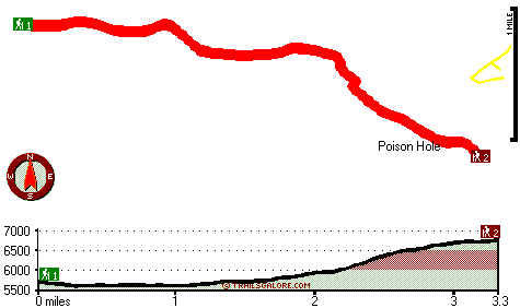
California hiking trails - Poison Hole Trail, Northern Sierra Nevada, El Dorado County

   
  Each great outdoors trail in California has its own character. You'll have to go far from Gardnerville Ranchos to get to Poison Hole Trail, but It's always enjoyable to backcountry walk here. With so many outdoors pursuits available in California you'll never get bored. You spend the whole trek in roughly the same elevation zone which means the conditions are about the same from start to finish. With its 6.6 miles of walking distance it's a mid length trek. There are so many wilderness trails in this region. The total elevation difference for this wilderness
    trail is 1,377 feet which is an average number. The hiking trails of the Northern Sierra Nevada are the best way to enjoy these mountains. Poison Hole Trail is a two ended wilderness trail with two trailheads, so if you can get a ride from someone, you can hike it just one way.
You should count on this hike taking about 5.5 hours, but you never know stuff could go wrong and you could get stuck so be prepared for that. This hiking trail is a mid length hiking trail with an average amount of climbing distance which makes this wilderness trail pleasant for hard core backpackers looking for adventure. When you're here in California backpacking along one of its great outdoors trails is so much fun. Ok, you've been cooped up too long, time to get out in the great outdoors a bit, and if you happen to be in El Dorado County of California,  
Poison Hole Trail is a brilliant local backpacking and hiking trail for doing a bit of leg stretching. Poison Hole Trail is quite long, so make sure you bring plenty of supplies. Poison Hole Trail gets lots of water; most of the rain falls through January, and the driest of the months is July. This area does get very dry sometimes, so do check for current fire restrictions before you go if you plan to bring a stove or make a camp fire. Don’t forget to check for any current restrictions or closures before you go. All through the months of summer here at Poison Hole Trail, high temperatures regularly get into the 80's. Once the sun is down it descends down to the 40's. For the duration of the wintertime this place gets highs in the 40's, and during the dark hours in the wintertime at Poison Hole Trail temperatures descend to the 20's. Backpacking trails are perfect and plentiful in California; among these are Poison Hole Trail in El Dorado County.

Briefly about the general area:
Whitewater paddling is not for everybody but if it's for you then we recommend American River - South Fork, and Poison Hole Trail is pleasant enough to spend more than a day at, Wentworth Springs Campground is a pleasant local campground. If only every place had this much outdoors amusing stuff, what a great globe it would be.
Cheese Camp Creek flows through this neighborhood, and there are some great whitewater spots on Silver Creek - South Fork. All year is a pleasant time in the Northern Sierra Nevada if you adore the outdoors. Don’t forget to check out Long Meadow if you're here at Poison Hole Trail, and camping at Pleasant Boat-In Campground is always a perfect experience. There's some flowing water nearby, Rocky Basin Creek is a stream you can check out while you're here; a great place like Poison Hole here at Poison Hole Trail is too magnificent to miss.

Location of Trailhead 1: Latitude 38.9615, Longitude -120.3637
- - Directions and Road Map

Location of Trailhead 2: Latitude 38.9472, Longitude -120.3146
- - Directions and Road Map


Trailhead 1 to Trailhead 2:
Total hiking length = 3.3 miles
Total climbing distance = 2 miles
Difficulty : Medium
Casual Hiking Pace: 3.5 hours
Fast Hiking Pace: 2 hours

Trailhead 2 to Trailhead 1:
Total hiking length = 3.3 miles
Total climbing distance = .5 miles
Difficulty : Easy
Casual Hiking Pace: 2.5 hours
Fast Hiking Pace: 1 hours
    Trailhead 1 back to Trailhead 1:
Total hiking length = 6.6 miles
Total climbing distance = 2.5 miles
Difficulty : Difficult
Casual Hiking Pace: 5.5 hours
Fast Hiking Pace: 3.5 hours

Trailhead 2 back to Trailhead 2:
Total hiking length = 6.6 miles
Total climbing distance = 2.5 miles
Difficulty : Difficult
Casual Hiking Pace: 5.5 hours
Fast Hiking Pace: 3.5 hours

Total elevation difference: 1377 feet


Squaw Valley Lodge, Squaw Valley
14 miles away
The Squaw Valley Lodge is Squaw Valleys Four Diamond awarded condominium suites resort; featuring world-class amenities and a true slope-side location; convenient to all of the areas activities. Nestl...
  
Plumpjack Squaw Valley Inn, Olympic Valley
15 miles away
60 room boutique hotel on 3 levels with 5 unique suites. Ski on-ski off property nestled at base of Squaw Valley USA ski resort. We feature two restaurants our own ski rental shop The Inn Shop and bou...
User input for Poison Hole Trail, Northern Sierra Nevada, El Dorado County, California:

Submit Input:
Your Name:
Write or Paste Input here:

Upload picture:      Review Guidelines


Outdoors Recreation Near Gardnerville Ranchos, Nevada
Very comprehensive list of a variety of outdoors recreation in the vicinity of Gardnerville Ranchos, Nevada, the metro area neareast to Poison Hole Trail. Find info on campgrounds, hiking trails, ski resorts, lakes, beaches, parks, whitewater and more.

Current weather conditions at Poison Hole Trail, Northern Sierra Nevada, El Dorado County, California
WXPort

Local climate location: LAKE SPAULDING 13 miles away

Village at Squaw Valley, Olympic Valley
15 miles away
The Village at Squaw Valley USA is an enchanting pedestrian village located at the base of Squaw Valley USA with approximately 300 condominium suites and a variety of boutique shops, restaurants, and ...

Resort At Squaw Creek, Olympic Valley
16 miles away
A 4-diamond luxury resort just minutes from North Lake Tahoe offering championship golf, spa, and family vacation recreation. Including ski-in ski-out access to Squaw Valley USA ski area....

More Hotels and Campgrounds Near Poison Hole Trail, Northern Sierra Nevada, El Dorado County, California

OTHER_INFO
  Northern Sierra Nevada Campgrounds
Complete list of all the campgrounds in the Northern Sierra Nevada.

Northern Sierra Nevada Outdoors Info
Complete outdoors info for the Northern Sierra Nevada.

California Hiking Trails
Complete list of all hiking trails in California

Books about hiking trails in California
List of books available on Amazon.com about hiking trails in California.

California Outdoors Index
This is a very comprehensive index of outdoors activities in the great state of California.


TOPO
High quality water resistant topo map of Poison Hole Trail, Northern Sierra Nevada, El Dorado County, California.

OUTDOORS_GUIDE
These outdoors activities are available near Poison Hole Trail.
 Trails Near Poison Hole Trail:
Loon Lake Trail, El Dorado County , 1 miles away, 2.7 hiking miles, 556 feet elevation difference
Sun Rock Trail, El Dorado County , 2 miles away,  4 hiking miles, 419 feet elevation difference
Highland Trail, El Dorado County , 4 miles away, 8 hiking miles, 2237 feet elevation difference
Red Peak Trail, El Dorado County , 5 miles away, 6.5 hiking miles, 1766 feet elevation difference
Dry Lakes Trail, El Dorado County , 5 miles away, 4.3 hiking miles, 879 feet elevation difference
McKinstry Trail, Placer County , 6 miles away, 8 hiking miles, 2734 feet elevation difference
Parsley Bar Trail, Placer County , 7 miles away, 1.6 hiking miles, 1582 feet elevation difference
 Camp Grounds Near Poison Hole Trail:
Wentworth Springs Campground, El Dorado County, 3 miles away
Pleasant Boat-In Campground, El Dorado County, 4 miles away
Yellow Jacket Campground, El Dorado County, 5 miles away
Sunset Campground, El Dorado County, 7 miles away
Hell Hole-In Campground, Placer County, 7 miles away
 Whitewater Near Poison Hole Trail:
Silver Creek - South Fork, El Dorado County County , 8 miles away, Class V+ - 2 miles long (Atherton Flat to Ice House Reservoir)
American River - South Fork, El Dorado County County , 10 miles away, Class III-V - 9.6 miles long (Kyburz to Riverton)
American River - South Fork, El Dorado County County , 12 miles away, Class IV-V - 9.6 miles long (Strawberry to Kyburz)
American River - South Fork, El Dorado County County , 14 miles away, Class III-IV - 3.5 miles long (Riverton to Peavine Ridge Road)
 Hotels Near Poison Hole Trail:
Squaw Valley Lodge, Squaw Valley , 14 miles away
Plumpjack Squaw Valley Inn, Olympic Valley , 15 miles away
Village at Squaw Valley, Olympic Valley , 15 miles away
Resort At Squaw Creek, Olympic Valley , 16 miles away
Pepper Tree Inn, Tahoe City , 17 miles away
 Lakes Near Poison Hole Trail
Berts Lake, El Dorado County , 1 miles away
Gerle Creek Divide Reservoir, El Dorado County , 5 miles away

Outdoors related information copyright © Stratus-Pikpuk, Inc. - Detailed hotel information copyright © Interactive Hotel Solutions