California hiking trails - Pine Ridge Trail, Santa Lucia Range, Monterey County

   
  While visiting this vicinity in California it's a nice idea to go hiking too. Every single California wilderness hiking trail is well worth a walk. We all need to get out in the fresh air once in a while, and if you happen to be in Monterey County of California, Pine Ridge Trail is a wonderful local hiking trail for doing a bit of leg stretching. Please follow all local rules about fires and camping. Pine Ridge Trail is 40.2 miles long; it's a long backcountry hiking trail. Pine Ridge Trail goes through some very different elevations, and that means that
    some parts of the backcountry hiking trail could be very different from other parts of it. Pine Ridge Trail has two trailheads which means you have the option of backcountry backpacking it one way if you have someone to pick you up at the other end. Pine Ridge Trail is many miles
long with an average amount of climbing distance which makes this backcountry trail perfect for hard core backpackers looking for adventure. At parts of the year this area sees very little rain, so do check for current fire restrictions before you go if you plan to bring a stove or make a camp fire. This backcountry walk should take you about 6 days, so better have big backpack to fit all the stuff you need. Backpacking trails are brilliant and plentiful in California; one of those is Pine Ridge Trail in Monterey County. You'll must go far from Salinas  
to get to Pine Ridge Trail, but there's great natural loveliness waiting here for you along it. Pine Ridge Trail has a total elevation difference of 4,802 feet which is a higher than average number. The hiking trails of the Santa Lucia Range are a nice way to explore these summits. This is a wilderness trail that is quite long, so don't forget to pack enough supplies. When you're here in California backcountry backpacking along one of its wilderness hiking trails is something that is always fun to do. Pine Ridge Trail is ordinarily a relatively arid spot; January is when you get the most rain here, and the driest of the months is July. Summertime brings highs in the 70's to Pine Ridge Trail, and the nighttime is a tad cooler of course, usually in the 50's. Throughout the wintertime this spot gets highs in the 50's with winter lows in the 40's overnight here at Pine Ridge Trail. This is a vicinity covered with lots of backcountry trails.

Briefly about the general area:
In the event that you don’t have a problem getting soaked, you can always go whitewater paddling on Carmel River, and if you're here, you might as well stop by Church Creek Divide. Big Pines is a forest close to Pine Ridge Trail that you can go to, and Arroyo Seco River has a fine whitewater paddling spot close by.
A spree to nearby McWay Cove is very relaxing, and why not camp at China Camp while you're here at Pine Ridge Trail. Man, is there heaps of entertaining stuff to do close to Pine Ridge Trail. There's some flowing water close by, Blue Creek is a stream you can stop at while here, and since you're here at Pine Ridge Trail it's a fine idea to stop at Bear Basin. These mountains rock, just check out all the exciting things to do in the Santa Lucia Range. A short spree to Sulphur Spring is always worthwhile, and if you came for an overnight stay Logwood Campground is a good location to camp.
You just have to like the Santa Lucia Range. Bear Basin Creek flows through this vicinity; a pleasant tour to Pine Valley is a delightful way to spend an afternoon. Lots of people from Salinas come to Pine Ridge Trail, and Pine Falls is a picturesque spot to stop by while you're at Pine Ridge Trail.

Location of Trailhead 1: Latitude 36.2449, Longitude -121.7716
- - Directions and Road Map

Location of Trailhead 2: Latitude 36.295, Longitude -121.5679
- - Directions and Road Map


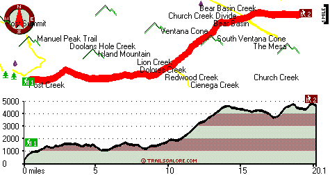
Trailhead 1 to Trailhead 2:
Total hiking length = 20.1 miles
Total climbing distance = 11.4 miles
Difficulty : Difficult
Casual Hiking Pace: 3.5 days
Fast Hiking Pace: 2 days

Trailhead 2 to Trailhead 1:
Total hiking length = 20.1 miles
Total climbing distance = 6.7 miles
Difficulty : Difficult
Casual Hiking Pace: 3 days
Fast Hiking Pace: 9 hours
    Trailhead 1 back to Trailhead 1:
Total hiking length = 40.2 miles
Total climbing distance = 18.1 miles
Difficulty : Difficult
Casual Hiking Pace: 6 days
Fast Hiking Pace: 4 days

Trailhead 2 back to Trailhead 2:
Total hiking length = 40.2 miles
Total climbing distance = 18.1 miles
Difficulty : Difficult
Casual Hiking Pace: 6 days
Fast Hiking Pace: 4 days

Total elevation difference: 4802 feet


Ventana Inn Big Sur, Big Sur
8 miles away
Situated on 243 acres, 1,200 feet above the Pacific Ocean. The property is known for its serene setting, rustic yet luxurious sophistication and romantic allure. Features include 26 newly remodeled su...
  
Post Ranch Inn, Big Sur
12 miles away
Unique architecture blends into its natural surroundings complemented with interior earth tones, high sweeping arches and skylights. In a spectacular setting, this 100 acre resort showcases the organi...
User input for Pine Ridge Trail, Santa Lucia Range, Monterey County, California:

Submit Input:
Your Name:
Write or Paste Input here:

Upload picture:      Review Guidelines


Outdoors Recreation Near Salinas, California
Very comprehensive list of a variety of outdoors recreation in the vicinity of Salinas, California, the metro area neareast to Pine Ridge Trail. Find info on campgrounds, hiking trails, ski resorts, lakes, beaches, parks, whitewater and more.

Current weather conditions at Pine Ridge Trail, Santa Lucia Range, Monterey County, California
WXPort

Local climate location: MONTEREY 7 miles away

Country Garden Inns, Carmel Valley
13 miles away
Nestled in the sunny Santa Lucia Mountains-just minutes from Carmel by the Sea California. Country Garden Inns offers two bed and breakfast inns with European hospitality. Both Hidden Valley Inn and A...

Bernardus Lodge, Carmel Valley
15 miles away
Nestled on verdant acres with stately pines and California oak trees, surrounded by a vineyard and the Santa Lucia mountains rising majestically in the background, Bernardus Lodge is a premier luxury ...

More Hotels and Campgrounds Near Pine Ridge Trail, Santa Lucia Range, Monterey County, California

OTHER_INFO
  Santa Lucia Range Campgrounds
Complete list of all the campgrounds in the Santa Lucia Range.

Santa Lucia Range Outdoors Info
Complete outdoors info for the Santa Lucia Range.

California Hiking Trails
Complete list of all hiking trails in California

Books about hiking trails in California
List of books available on Amazon.com about hiking trails in California.

California Outdoors Index
This is a very comprehensive index of outdoors activities in the great state of California.


TOPO
High quality water resistant topo map of Pine Ridge Trail, Santa Lucia Range, Monterey County, California.

OUTDOORS_GUIDE
These outdoors activities are available near Pine Ridge Trail.
 Trails Near Pine Ridge Trail:
Church Creek Trail, Monterey County , 2 miles away,  3.8 hiking miles, 1279 feet elevation difference
Miller Canyon Trail, Monterey County , 3 miles away,  15.6 hiking miles, 2327 feet elevation difference
Big Sur Trail, Monterey County , 4 miles away,  15.2 hiking miles, 1949 feet elevation difference
Hennicksons Ridge Trail, Monterey County , 4 miles away, 5.9 hiking miles, 2356 feet elevation difference
South Fork Trail, Monterey County , 5 miles away,  7.8 hiking miles, 1563 feet elevation difference
Carmel River Trail, Monterey County , 5 miles away,  29.4 hiking miles, 3023 feet elevation difference
Rattlesnake Creek Trail, Monterey County , 6 miles away,  7 hiking miles, 1350 feet elevation difference
 Camp Grounds Near Pine Ridge Trail:
China Camp, Monterey County, 6 miles away
Logwood Campground, Monterey County, 6 miles away
Indian Valley Campground, Monterey County, 6 miles away
Rattlesnake Campground, Monterey County, 6 miles away
Upper Higgins Campground, Monterey County, 6 miles away
 Whitewater Near Pine Ridge Trail:
Carmel River, Monterey County County , 9 miles away, Class II-III(IV) - 10 miles long (Los Padres Reservoir to Carmel Valley)
Arroyo Seco River, Monterey County County , 10 miles away, Class IV(V) - 3 miles long (Willowcreek Bridge to Arroyo Seco Picnic Area)
Big Sur River, Monterey County County , 11 miles away, Class II+ - 4 miles long (Pfeiffer Big Sur State Park to Motels)
Little Sur River, Monterey County County , 15 miles away, Class III-IV - 7 miles long (Pico Blanco BSouth Carolina to Highway 1)
Arroyo Seco River, Monterey County County , 16 miles away, Class III - 14.5 miles long (Arroyo Seco Picnic Area to Route G16 bridge)
 National Parks Near Pine Ridge Trail:
Pinnacles National Monument, Paicines - CA , 45 miles away
 Hotels Near Pine Ridge Trail:
Ventana Inn Big Sur, Big Sur , 8 miles away
Post Ranch Inn, Big Sur , 12 miles away
Country Garden Inns, Carmel Valley , 13 miles away
Bernardus Lodge, Carmel Valley , 15 miles away
Big Sur Lodge, Big Sur , 18 miles away

Outdoors related information copyright © Stratus-Pikpuk, Inc. - Detailed hotel information copyright © Interactive Hotel Solutions