| |
Pilot Ridge Trail has a total elevation difference of 1,023 feet which is an average number. This trail sometimes gets very dry, so do check for current fire restrictions before you go if you plan to bring a stove or make a camp fire. The time needed for this backcountry walk is roughly 3.5 hours, but you never know stuff could go wrong and you could get stuck so be prepared for that. This is a two-ended trail with two trailheads, so if you can get a ride from someone, you can walk it just one way. The trail stays roughly within the same elevation zone the whole time, so you won’t have to worry about different climate zones along your backcountry hike. With its 4.2 miles of walking distance it's an average length trail. This is not a very long trail but it's always magnificent to bring some emergency supplies, you never know what could happen.
|
Trailhead 1 to Trailhead 2:
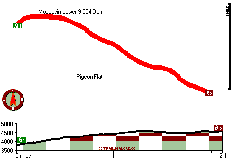
Total hiking length = 2.1 miles
Total climbing distance = 1.4 miles
Difficulty : Difficult
Casual Hiking Pace:
2 hours
Fast Hiking Pace:
1 hours
Trailhead 2 to Trailhead 1:
Total hiking length = 2.1 miles
Total climbing distance = .3 miles
Difficulty : Easy
Casual Hiking Pace:
1.5 hours
Fast Hiking Pace:
1 hours
| | Trailhead 1 back to Trailhead 1:
Total hiking length = 4.2 miles
Total climbing distance = 1.7 miles
Difficulty : Medium
Casual Hiking Pace:
3.5 hours
Fast Hiking Pace:
2.5 hours
Trailhead 2 back to Trailhead 2:
Total hiking length = 4.2 miles
Total climbing distance = 1.7 miles
Difficulty : Medium
Casual Hiking Pace:
3.5 hours
Fast Hiking Pace:
2.5 hours
|
Total elevation difference: 1023 feet
|


