| |
|
| | There are numerous hiking trails in California, and each one is different from the others. In California you never run out of outdoors fun. Piedra Blanca National Recreation Trail is a long trip away from Oxnard-Thousand Oaks-Ventura, but it is one of many wonderful backpacking trails in this area. This backpacking and hiking trail sometimes gets very dry, so do check for current fire restrictions before you go if you plan to bring a stove or make a camp fire. Can’t wait to get out in the wilderness, Piedra Blanca National Recreation Trail in Ventura |
|
County, California is a glorious location to go. If you happen to be in California, why not go backcountry hiking, it is the magnificent thing to do. This is a backpacking and hiking trail that is quite long, so do pack enough food to last the whole trip. Piedra Blanca National
| | Recreation Trail is a very long wilderness trail having an average number of uphill miles which makes this a very tough backcountry hiking trail for advanced walkers looking for a good challenge. Piedra Blanca National Recreation Trail has a total elevation difference of 2,662 feet which is a higher than average number. This trek should take you about 3 days, so it's a brilliant thing if your backpack is big enough to do the job. Some parts of Piedra Blanca National Recreation Trail are much higher up than other parts of the wilderness hiking trail which | |
|
of course means you need to be prepared for different conditions on different parts of the wilderness hiking trail. An average amount of rainfall falls at Piedra Blanca National Recreation Trail; during February this area sees the most rain while July is ordinarily the driest month.
There are two trailheads to chose from, one in each end, so if you can get a ride from someone, you can backcountry hike it just one way. There are so many magnificent hiking trails for backcountry hiking in California, and one of these is Piedra Blanca National Recreation Trail
in Ventura County. Piedra Blanca National Recreation Trail is 19 miles long; it's considered a longer backcountry hike. High temperatures at Piedra Blanca National Recreation Trail through the summertime months are in the 90's, and during the night it cools down to the 50's. High
temperatures during the wintertime are normally in the 60's, and after the sun is down during the wintertime temperatures at Piedra Blanca National Recreation Trail sink into the 30's. The stunning wilderness trails of the Sierra Madre are the best way to enjoy these mountains.
This is just one of a large number of backcountry hiking trails in this neighborhood. Don’t forget to check for any current restrictions or closures before you go.
Briefly about the general area: If you have a thing about the outdoors you'll have a thing about it here
in the Sierra Madre. Some of the water close by flows, like Derrydale Creek. Get your heart beating on the great whitewater of Sespe Creek; swing by Potrero John Creek it's a delightful place to go to. I can't stop, cause I'm havin' a delightful time here at Piedra Blanca National
Recreation Trail. Camping is available at Haddock Campground, and Raspberry Spring is an inspiring site to take a look at during your stay. You'll beyond doubt wish for more hours in a day to enjoy all the cool stuff in the Sierra Madre. Do set aside some time for Thorn Meadows
while you're here at Piedra Blanca National Recreation Trail, and close by you locate perfect places like Sespe Gorge. The views at Channel Islands National Park will blow your mind, and if you came for an overnight stay Three Mile Campground is a glorious spot to camp. A pleasant trip to Lilly Meadows is a good way to spend an afternoon, and the beauty of mother nature reveals herself at Rose Valley Falls.
|
|
Location of Trailhead 1: Latitude 34.6807, Longitude -119.3075 - - Directions and Road Map
Location of Trailhead 2: Latitude 34.6189, Longitude -119.1829 - - Directions and Road Map

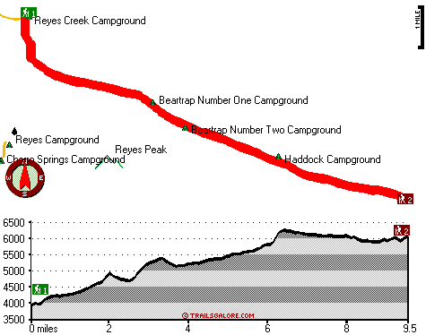
Trailhead 1 to Trailhead 2: Total hiking length = 9.5 miles Total climbing distance = 5.8 miles Difficulty : Difficult Casual Hiking Pace:
1.5 days
Fast Hiking Pace:
5.5 hours
Trailhead 2 to Trailhead 1: Total hiking length = 9.5 miles Total climbing distance = 2.8 miles Difficulty : Difficult Casual Hiking Pace:
7.5 hours
Fast Hiking Pace:
4 hours
| | Trailhead 1 back to Trailhead 1: Total hiking length = 19 miles Total climbing distance = 8.6 miles Difficulty : Difficult Casual Hiking Pace:
3 days
Fast Hiking Pace:
2 days
Trailhead 2 back to Trailhead 2: Total hiking length = 19 miles Total climbing distance = 8.6 miles Difficulty : Difficult Casual Hiking Pace:
3 days
Fast Hiking Pace:
2 days
|
Total elevation difference: 2662 feet

Best Western Casa Ojai, Ojai
|
10 miles away
Explore the marvels of the Ojai Valley at this Ojai, California hotel and enjoy a host of unique amenities that appeal to both the leisure and business travelers. The Best Western Ojai Casa is the Oj...
|
| |
The Capri, Ojai
|
10 miles away
Nestled in the Ojai Valley, Our Limited Luxury Boutique hotel is designed for the discerning traveler who has high expectations of comfort, without the high price. Whether you choose the Mountain view...
|
|
User input for Piedra Blanca National Recreation Trail, Sierra Madre, Ventura County, California:

Outdoors Recreation Near Oxnard-Thousand Oaks-Ventura, California Very comprehensive list of a variety of outdoors recreation in the vicinity of Oxnard-Thousand Oaks-Ventura, California, the metro area neareast to Piedra Blanca National Recreation Trail. Find info on campgrounds, hiking trails, ski resorts, lakes, beaches, parks, whitewater and more.
More Hotels and Campgrounds Near Piedra Blanca National Recreation Trail, Sierra Madre, Ventura County, California
| |
| |
 |
|
| These outdoors activities are available near Piedra Blanca National Recreation Trail. |
| | Trails Near Piedra Blanca National Recreation Trail:
 |
Middle Sespe Trail, Ventura
County
, 4 miles away, 3.2 hiking miles, 314 feet elevation difference |
 |
Cedar Lake Trail, Ventura
County
, 6 miles away, 4.7 hiking miles, 2058 feet elevation difference |
 |
Rose Lion Trail, Ventura
County
, 7 miles away, 5.6 hiking miles, 2160 feet elevation difference |
 |
Chorro Grande Trail, Ventura
County
, 7 miles away, 3.7 hiking miles, 3309 feet elevation difference |
 |
McGuire Trail, Ventura
County
, 8 miles away, 9.4 hiking miles, 2566 feet elevation difference |
 |
Pratt Trail, Ventura
County
, 9 miles away, 5.3 hiking miles, 2337 feet elevation difference |
 |
Ortega Trail, Ventura
County
, 9 miles away, 18.2 hiking miles, 1624 feet elevation difference |
|
| | Whitewater Near Piedra Blanca National Recreation Trail:
 |
Sespe Creek, Ventura County
County
, 15 miles away, Class IV-V - 31.5 miles long (Lion Campground to Highway 126 bridge) |
 |
Piru Creek, Los Angeles / Ventura County
County
, 32 miles away, Class IV - 15 miles long (Pyramid Lake to Lake Piru) |
 |
Piru Creek, Ventura County
County
, 34 miles away, Class II - 4 miles long (Lake Piru to Santa Clara River) |
|
| | Hotels Near Piedra Blanca National Recreation Trail:
 |
Best Western Casa Ojai, Ojai
, 10 miles away |
 |
The Capri, Ojai
, 10 miles away |
 |
Hummingbird Inn, Ojai
, 10 miles away |
 |
Su Nido Inn, Ojai
, 10 miles away |
 |
Ojai Valley Inn and Spa, Ojai
, 11 miles away |
|
|
|
 |
|