California hiking trails - Panorama Trail, Central Sierra Nevada, Mariposa County

   
  Backcountry trekking in California is so much fun. Hey, time for a backcountry trek don’t you think? Panorama Trail in Mariposa County, California is just the place. Every backcountry trail in California is different from the others. The length of Panorama Trail is on the longer side having an average number of uphill miles which makes this hiking and backpacking trail magnificent for hard core backpackers looking for adventure. Of course, this is an overnight backcountry trek, 2 days normally, so make sure you've got all your overnight gear packed. This
    backcountry hiking trail sometimes gets very dry, so do check for current fire restrictions before you go if you plan to bring a stove or make a camp fire. The total elevation difference for Panorama Trail is 3,896 feet which is higher than average. Being 14.2 miles long; it's
longer than many backcountry hiking trails. Summertime at Panorama Trail comes with high temperatures in the 80's. When the night sets in temperatures descend down into the 50's. The wintertime brings highs down to the 40's, and overnight lows at Panorama Trail through the wintertime regularly descend into the 20's. The wilderness trails of the Central Sierra Nevada are a really glorious way to spend quality time in the great outdoors. This is a two-ended great outdoors trail with two trailheads which means you have the option of trekking it one way if you  
have someone to pick you up at the other end. Some parts of Panorama Trail are much higher up than other parts of the backcountry hiking trail which of course means you need to be prepared for different conditions on different parts of the backcountry hiking trail. This is one of many hiking and backpacking trails in the surrounding region. While visiting this region in California it's an excellent idea to go hiking too. Don’t forget to check for any current restrictions or closures before you go. Panorama Trail gets a lot of water; the wettest month of the year is ordinarily January, that's the one that rains the most, and July on the other hand is the driest. There are backcountry trails all over California, and Panorama Trail in Mariposa County is one of them. Panorama Trail is to be found a rather long tour from Madera, but it sure is a a perfect wilderness hiking trail. This is a long backcountry hiking trail, so make sure you bring plenty of supplies.

Briefly about the general area:
Take a side trip to Illilouette Creek, and a journey to Yosemite National Park is worthwhile. You just can't picture the amount of outdoors entertaining things the Central Sierra Nevada has to offer. Places like Pothole Meadows are pleasant to stop at, and whitewater paddling is glorious on Yosemite Creek.
Whohoo, so many amusing things in one place! The Central Sierra Nevada rocks! Tenaya Creek is a scenic stream that is worth checking out. There's so much to do here at Panorama Trail that you need to camp here for a while, Upper Pines Campground is a fine place for that. Any time is a wonderful time at Panorama Trail if you like the outdoors. If you feel like a little side tour, try Illilouette Gorge, and Illilouette Falls is a charming site to have a look at while you're at Panorama Trail.
Paddling on Tenaya Creek is so much fun, and a short journey to Vernal Fall is always worthwhile. Stoneman Meadow is a tremendous place to stretch your legs a bit, and Panorama Trail is wonderful enough to spend more than a day at, Lower Pines Campground is a wonderful local campground.

Location of Trailhead 1: Latitude 37.7252, Longitude -119.5745
- - Directions and Road Map

Location of Trailhead 2: Latitude 37.7325, Longitude -119.5597
- - Directions and Road Map


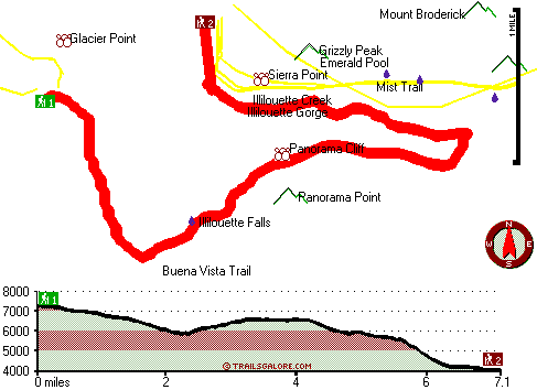
Trailhead 1 to Trailhead 2:
Total hiking length = 7.1 miles
Total climbing distance = 1.1 miles
Difficulty : Difficult
Casual Hiking Pace: 5 hours
Fast Hiking Pace: 2.5 hours

Trailhead 2 to Trailhead 1:
Total hiking length = 7.1 miles
Total climbing distance = 4.8 miles
Difficulty : Difficult
Casual Hiking Pace: 7.5 hours
Fast Hiking Pace: 4 hours
    Trailhead 1 back to Trailhead 1:
Total hiking length = 14.2 miles
Total climbing distance = 5.9 miles
Difficulty : Difficult
Casual Hiking Pace: 2 days
Fast Hiking Pace: 8 hours

Trailhead 2 back to Trailhead 2:
Total hiking length = 14.2 miles
Total climbing distance = 5.9 miles
Difficulty : Difficult
Casual Hiking Pace: 2 days
Fast Hiking Pace: 8 hours

Total elevation difference: 3896 feet


Wawona Hotel, Yosemite National Park
5 miles away
Wawona is one of the oldest mountain resort hotels in California and a National Historic Landmark. Its verdant meadows, rushing streams, and tranquility make this a favorite of those who prefer a rela...
  
Yosemite Lodge at the Falls, Yosemite National Park
5 miles away
As the closest property to Yosemite Falls, Yosemite Lodge is an idyllic spot for families, group retreats and visitors seeking to blend the comforts of a hotel while exploring the wilderness. In 1998,...
User input for Panorama Trail, Central Sierra Nevada, Mariposa County, California:

Submit Input:
Your Name:
Write or Paste Input here:

Upload picture:      Review Guidelines


Outdoors Recreation Near Madera, California
Very comprehensive list of a variety of outdoors recreation in the vicinity of Madera, California, the metro area neareast to Panorama Trail. Find info on campgrounds, hiking trails, ski resorts, lakes, beaches, parks, whitewater and more.

Current weather conditions at Panorama Trail, Central Sierra Nevada, Mariposa County, California
WXPort

Local climate location: CHERRY VALLEY DAM 7 miles away

Housekeeping Camp, Yosemite National Park
5 miles away
Housekeeping Camp is located along a section of the Merced River in the center of Yosemite Valley. This is the ideal location for those who like to camp outdoors without the bother of setting up a ten...

Ahwahnee Hotel, Yosemite National Park
5 miles away
As a National Historical Landmark and one of the most distinctive resort hotels in North America, The Ahwahnee is well known for its great granite fa?ade, striking beamed ceilings, massive stone heart...

More Hotels and Campgrounds Near Panorama Trail, Central Sierra Nevada, Mariposa County, California

OTHER_INFO
  Central Sierra Nevada Campgrounds
Complete list of all the campgrounds in the Central Sierra Nevada.

Central Sierra Nevada Outdoors Info
Complete outdoors info for the Central Sierra Nevada.

California Hiking Trails
Complete list of all hiking trails in California

Books about hiking trails in California
List of books available on Amazon.com about hiking trails in California.

California Outdoors Index
This is a very comprehensive index of outdoors activities in the great state of California.


TOPO
High quality water resistant topo map of Panorama Trail, Central Sierra Nevada, Mariposa County, California.

OUTDOORS_GUIDE
These outdoors activities are available near Panorama Trail.
 Trails Near Panorama Trail:
Buena Vista Trail, Madera County , 0 miles away,  22.4 hiking miles, 2797 feet elevation difference
Mist Trail, Mariposa County , 1 miles away,  2.8 hiking miles, 1214 feet elevation difference
Mono Meadow Trail, Mariposa County , 2 miles away,  5.2 hiking miles, 1019 feet elevation difference
Four Mile Trail, Mariposa County , 2 miles away, 3.7 hiking miles, 3869 feet elevation difference
North Dome Trail, Mariposa County , 3 miles away, 14.4 hiking miles, 4985 feet elevation difference
Yosemite Falls Trail, Mariposa County , 3 miles away,  9.4 hiking miles, 3958 feet elevation difference
Half Dome Trail, Mariposa County , 3 miles away,  11.6 hiking miles, 5142 feet elevation difference
 Camp Grounds Near Panorama Trail:
Upper Pines Campground, Mariposa County, 1 miles away
Lower Pines Campground, Mariposa County, 2 miles away
North Pines Campground, Mariposa County, 2 miles away
Upper River Campground, Mariposa County, 2 miles away
Lower River Campground, Mariposa County, 2 miles away
 Whitewater Near Panorama Trail:
Yosemite Creek, Mariposa County County , 5 miles away, Class IV-V - 8 miles long (Tioga Pass Road to Yosemite Falls)
Tenaya Creek, Mariposa County County , 7 miles away, Class V - 1 miles long (Super Slide)
Merced River - South Fork, Mariposa County County , 9 miles away, Class V+ - 16 miles long (Upper)
Merced River, Mariposa County County , 10 miles away, Class V - 4.8 miles long (Routes 120-140 Junction to Arch Rock Entrance Station)
Tuolumne River, Tuolumne County County , 11 miles away, Class IV-V+ - 32 miles long (Tioga Road Bridge to Hetch Hetchy Reservoir)
 National Parks Near Panorama Trail:
Yosemite National Park, Yosemite National Park - CA , 10 miles away
Devils Postpile National Monument, Mammoth Lakes - CA , 57 miles away
 Hotels Near Panorama Trail:
Wawona Hotel, Yosemite National Park , 5 miles away
Yosemite Lodge at the Falls, Yosemite National Park , 5 miles away
Housekeeping Camp, Yosemite National Park , 5 miles away
Ahwahnee Hotel, Yosemite National Park , 5 miles away
Curry Village, Yosemite National Park , 5 miles away
 Lakes Near Panorama Trail
Emerald Pool, Mariposa County , 1 miles away
Mirror Lake, Mariposa County , 2 miles away

Outdoors related information copyright © Stratus-Pikpuk, Inc. - Detailed hotel information copyright © Interactive Hotel Solutions