California hiking trails - Owl Creek Trail, Warner Mountains, Modoc County

   
  Tom lee meadows is privately owned property, FYI Says Ryan
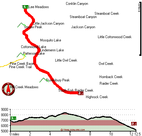
No chance of getting bored in California if you like the wilderness. Spending too much time indoors got you down? No problem, Owl Creek Trail in Modoc County, California is just what you need. There are plenty of hiking trails in California; each one of them is worth backcountry backpacking. Now, this is roughly a 4-day hike, so it's a nice thing if your backpack is big enough to do the job. This is just one of a large number of backpacking trails in this vicinity. Some parts of this
    hiking trail are much higher up than other parts of the hiking trail, and that means that some parts of the hiking trail could be very different from other parts of it. This great outdoors hiking trail sometimes gets very dry, so don’t forget to check for any current fire restrictions
before you go. Backpacking here in California is always a cool thing to do. Far from civilization you find Owl Creek Trail, and it sure is a an outstanding wilderness hiking trail. There are so many glorious hiking trails for backcountry backpacking in California; one of these is Owl Creek Trail in Modoc County. Keep in mind that this is a long great outdoors hiking trail, so make sure you bring plenty of supplies. Owl Creek Trail has a total elevation difference of 4,124 feet which is a higher than average number. Owl Creek Trail is typically a pretty  
dried out location; through November this vicinity sees the most rain, and the driest month of the year is July. The pretty backpacking trails of the Warner Mountains are a really great way to spend quality time in the wilderness. Please follow all local rules about fires and camping. Being 25 miles long; it's considered a longer walk. This hiking trail has two trailheads, so trekking it one way is an option if you can arrange for a ride back. Owl Creek Trail is a backpacking trail of great length with an average amount of climbing distance which makes it a good backpacking trail for experienced walkers in great shape. For the duration of the warmest time of the year at Owl Creek Trail temperatures are generally in the 80's. Once the sun is down it falls down to the 50's. The wintertime brings highs down to the 30's, and overnight lows in the 10's for Owl Creek Trail.

Briefly about the general area:
Why not camp at Stough Campground since you're here at Owl Creek Trail, and why not stop by close by Little Owl Creek since you're here at Owl Creek Trail. Don't leave Owl Creek Trail without first paying a visit to Pine Spring; nearby you come across Kaiser Canyon which is a good site to take a look at. And if that's not enough, there's a lot more to do near Owl Creek Trail. Places like Tom Lee Meadows are wonderful to explore.
Soup Spring is an inspiring place to stop by during your stay, and camping is available at Soup Spring Campground. If you like the outdoors you'll like it here in the Warner Mountains. Pine Creek Basin is a great place to stretch your legs a bit, and it's a good idea to visit South Fork Raider Creek.

Location of Trailhead 1: Latitude 41.4433, Longitude -120.2136
- - Directions and Road Map

Location of Trailhead 2: Latitude 41.3268, Longitude -120.1392
- - Directions and Road Map


Trailhead 1 to Trailhead 2:
Total hiking length = 12.5 miles
Total climbing distance = 4.6 miles
Difficulty : Difficult
Casual Hiking Pace: 2 days
Fast Hiking Pace: 6 hours

Trailhead 2 to Trailhead 1:
Total hiking length = 12.5 miles
Total climbing distance = 7.1 miles
Difficulty : Difficult
Casual Hiking Pace: 2 days
Fast Hiking Pace: 7 hours
    Trailhead 1 back to Trailhead 1:
Total hiking length = 25 miles
Total climbing distance = 11.7 miles
Difficulty : Difficult
Casual Hiking Pace: 4 days
Fast Hiking Pace: 2.5 days

Trailhead 2 back to Trailhead 2:
Total hiking length = 25 miles
Total climbing distance = 11.7 miles
Difficulty : Difficult
Casual Hiking Pace: 4 days
Fast Hiking Pace: 2.5 days

Total elevation difference: 4124 feet


Best Western Trailside Inn, Alturas
24 miles away
Here in Modoc county, surrounding the Best Western Trailside Inn in Alturas, is the history of the American west. From the days of discovery and exploration to the glory structures of another generat...
  
Super 8 Motel - Alturas, Alturas
24 miles away
* AAA approved/2 Diamonds. Superstart Breakfast, high speed wireless and wired internet access, microwaves/refrigerators, hairdryers, cable TV w/HBO, ESPN, suites available. Golf Course 1 mile, Ski Ar...
User input for Owl Creek Trail, Warner Mountains, Modoc County, California:

Submit Input:
Your Name:
Write or Paste Input here:

Upload picture:      Review Guidelines


Outdoors Recreation Near Reno-Sparks, Nevada
Very comprehensive list of a variety of outdoors recreation in the vicinity of Reno-Sparks, Nevada, the metro area neareast to Owl Creek Trail. Find info on campgrounds, hiking trails, ski resorts, lakes, beaches, parks, whitewater and more.

Current weather conditions at Owl Creek Trail, Warner Mountains, Modoc County, California
WXPort

Local climate location: CEDARVILLE 8 miles away

Budget Inn - Lakeview, Lakeview
42 miles away
Conveniently located just one block from the intersection of Highway 395 and Highway 140. The Budget Inn-Lakeview is located in nice quiet location, next to a restaurant, and is also within easy walki...

Best Western Skyline Motor Lodge, Lakeview
42 miles away
Discover this Lakeview, Oregon hotel offering superior accommodations in the heart of spectacular Southeast Oregon. Located in Oregon's tallest town, the Best Western Skyline Motor Lodge is ideally s...

More Hotels and Campgrounds Near Owl Creek Trail, Warner Mountains, Modoc County, California

OTHER_INFO
  Warner Mountains Campgrounds
Complete list of all the campgrounds in the Warner Mountains.

Warner Mountains Outdoors Info
Complete outdoors info for the Warner Mountains.

California Hiking Trails
Complete list of all hiking trails in California

Books about hiking trails in California
List of books available on Amazon.com about hiking trails in California.

California Outdoors Index
This is a very comprehensive index of outdoors activities in the great state of California.


TOPO
High quality water resistant topo map of Owl Creek Trail, Warner Mountains, Modoc County, California.

OUTDOORS_GUIDE
These outdoors activities are available near Owl Creek Trail.
 Trails Near Owl Creek Trail:
Pine Creek Trail, Modoc County , 3 miles away,  8.6 hiking miles, 2881 feet elevation difference
Emerson Creek Trail, Modoc County , 7 miles away,  7 hiking miles, 2630 feet elevation difference
Poison Flat Trail, Modoc County , 8 miles away,  5.2 hiking miles, 1721 feet elevation difference
East Creek Trail, Modoc County , 9 miles away, 7.5 hiking miles, 2136 feet elevation difference
Bearcamp Flat Trail, Modoc County , 9 miles away, 1.1 hiking miles, 527 feet elevation difference
 Camp Grounds Near Owl Creek Trail:
Soup Spring Campground, Modoc County, 7 miles away
Stough Campground, Modoc County, 9 miles away
Cedar Pass Campground, Modoc County, 10 miles away
Little Meadows Campground, Modoc County, 14 miles away
Blue Lake Campground, Lassen County, 14 miles away
 Hotels Near Owl Creek Trail:
Best Western Trailside Inn, Alturas , 24 miles away
Super 8 Motel - Alturas, Alturas , 24 miles away
Budget Inn - Lakeview, Lakeview , 42 miles away
Best Western Skyline Motor Lodge, Lakeview , 42 miles away
Fremont Inn, Lakeview , 43 miles away

Outdoors related information copyright © Stratus-Pikpuk, Inc. - Detailed hotel information copyright © Interactive Hotel Solutions