California hiking trails - Oak Grove Trail, Santa Lucia Range, Monterey County

   
  There are plenty of hiking trails in California; each one of them is beautiful in its own way. Quite far from Salinas you locate Oak Grove Trail, but if you're looking for a splendid site to go backcountry trekking, this is a splendid selection. You can't spend all your time indoors you need to get out once in a while, and Oak Grove Trail in Monterey County, California is a really splendid site to spend some time. Oak Grove Trail stays roughly within the same elevation zone the whole time, so you get pretty much the same conditions along the whole wilderness
    hiking trail. Don’t forget to check for any current restrictions or closures before you go. Oak Grove Trail is a two ended trail with two trailheads which means you have the option of backpacking it one way if you have someone to pick you up at the other end. There are many splendid
hiking trails in California; one of them being Oak Grove Trail in Monterey County. Around Oak Grove Trail you don’t get a lot of rain; January is the wettest month with most rain while July is the month with the least amount of precipitation. A visit to California is not complete without some backcountry backpacking. These backpacking trails here in the Santa Lucia Range are a brilliant way to explore these hills. At Oak Grove Trail all through the long summer days highs are in the 70's. Summer overnight lows sink down to the 50's. The cold days of the  
winter come with highs in the 50's, and winter nights come with lows in the 40's to Oak Grove Trail. The time needed for this backcountry trek is roughly 1 hours, but you never know stuff could go wrong and you could get stuck so be prepared for that. Oak Grove Trail is a very short backpacking trail with an average amount of climbing distance which makes it a glorious backcountry hiking trail for the average person looking for a glorious adventure. This is not a very long hiking trail but you should still bring some emergency supplies just in case something happens. There are so many backcountry hiking trails in this neighborhood. Oak Grove Trail is 1.2 miles long it's shorter than many wilderness hiking trails. At parts of the year this vicinity sees very little rain, so don’t forget to check for any current fire restrictions before you go. Backcountry hiking here in California never gets boring. The total elevation difference for Oak Grove Trail is 204 feet which is lower than average.

Briefly about the general area:
Near Oak Grove Trail you stumble on wonderful places like Pfeiffer Gulch, and Oak Grove Trail is a place with many visitors from Salinas. If you have a thing about the outdoors you'll have a thing about it here in the Santa Lucia Range. Post Creek is a splendid local stream; Wreck Beach is a scenic beach to have a look at.
Paddling on Big Sur River is so much fun, and camping at P B S S P South Campground is always a fine experience. This location, the Santa Lucia Range, has so much outdoors amusing things. This river is so great. Oak Grove Trail is brilliant enough to spend more than a day at, Sawmill Flat Campground is a brilliant local campground, and you have to certainly explore beautiful Pfeiffer Beach since you're here.
And that's not all you can do here at Oak Grove Trail. A trip to Oak Grove Trail wouldn't be complete without taking a look at Pfeiffer Falls, and swing by Pfeffer-Redwood Creek it's a wonderful location to go to.

Location of Trailhead 1: Latitude 36.2527, Longitude -121.7825
- - Directions and Road Map

Location of Trailhead 2: Latitude 36.2488, Longitude -121.774
- - Directions and Road Map


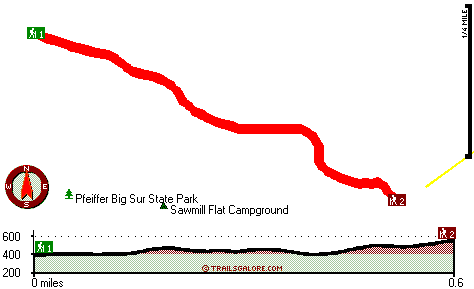
Trailhead 1 to Trailhead 2:
Total hiking length = .6 miles
Total climbing distance = .3 miles
Difficulty : Medium
Casual Hiking Pace: .5 hours
Fast Hiking Pace: .5 hours

Trailhead 2 to Trailhead 1:
Total hiking length = .6 miles
Total climbing distance = .2 miles
Difficulty : Medium
Casual Hiking Pace: .5 hours
Fast Hiking Pace: .5 hours
    Trailhead 1 back to Trailhead 1:
Total hiking length = 1.2 miles
Total climbing distance = .5 miles
Difficulty : Medium
Casual Hiking Pace: 1 hours
Fast Hiking Pace: .5 hours

Trailhead 2 back to Trailhead 2:
Total hiking length = 1.2 miles
Total climbing distance = .5 miles
Difficulty : Medium
Casual Hiking Pace: 1 hours
Fast Hiking Pace: .5 hours

Total elevation difference: 204 feet


Ventana Inn and Spa, Big Sur
2 miles away
  
Ventana Inn And Spa, Big Sur
2 miles away
User input for Oak Grove Trail, Santa Lucia Range, Monterey County, California:

Submit Input:
Your Name:
Write or Paste Input here:

Upload picture:      Review Guidelines


Outdoors Recreation Near Salinas, California
Very comprehensive list of a variety of outdoors recreation in the vicinity of Salinas, California, the metro area neareast to Oak Grove Trail. Find info on campgrounds, hiking trails, ski resorts, lakes, beaches, parks, whitewater and more.

Current weather conditions at Oak Grove Trail, Santa Lucia Range, Monterey County, California
WXPort

Local climate location: MONTEREY 17 miles away

Big Sur Lodge, Big Sur
9 miles away

Country Garden Inns, Carmel Valley
13 miles away

More Hotels and Campgrounds Near Oak Grove Trail, Santa Lucia Range, Monterey County, California

OTHER_INFO
  Santa Lucia Range Campgrounds
Complete list of all the campgrounds in the Santa Lucia Range.

Santa Lucia Range Outdoors Info
Complete outdoors info for the Santa Lucia Range.

California Hiking Trails
Complete list of all hiking trails in California

Books about hiking trails in California
List of books available on Amazon.com about hiking trails in California.

California Outdoors Index
This is a very comprehensive index of outdoors activities in the great state of California.


TOPO
High quality water resistant topo map of Oak Grove Trail, Santa Lucia Range, Monterey County, California.

OUTDOORS_GUIDE
These outdoors activities are available near Oak Grove Trail.
 Trails Near Oak Grove Trail:
Buzzards Roost Trail, Monterey County , 1 miles away, 1.5 hiking miles, 864 feet elevation difference
Manuel Peak Trail, Monterey County , 1 miles away,  10.8 hiking miles, 3534 feet elevation difference
Big Sur Trail, Monterey County , 8 miles away,  15.2 hiking miles, 1949 feet elevation difference
San Clemente Trail, Monterey County , 9 miles away,  7 hiking miles, 714 feet elevation difference
Rattlesnake Creek Trail, Monterey County , 10 miles away,  7 hiking miles, 1350 feet elevation difference
Pine Ridge Trail, Monterey County , 10 miles away, 20.1 hiking miles, 4802 feet elevation difference
Carmel River Trail, Monterey County , 11 miles away,  29.4 hiking miles, 3023 feet elevation difference
 Camp Grounds Near Oak Grove Trail:
Sawmill Flat Campground, Monterey County, 0 miles away
P B S S P South Campground, Monterey County, 0 miles away
Tin House Campground, Monterey County, 3 miles away
Vado Campground, Monterey County, 3 miles away
Launtz Creek Campground, Monterey County, 3 miles away
 Beaches Near Oak Grove Trail:
Wreck Beach, Monterey County , 2 miles away
Pfeiffer Beach, Monterey County , 3 miles away
 Whitewater Near Oak Grove Trail:
Big Sur River, Monterey County County , 1 miles away, Class II+ - 4 miles long (Pfeiffer Big Sur State Park to Motels)
 National Parks Near Oak Grove Trail:
Pinnacles National Monument, Paicines - CA , 55 miles away
 Hotels Near Oak Grove Trail:
Big Sur Lodge, Big Sur , 1 miles away
Ventana Inn and Spa, Big Sur , 2 miles away
Ventana Inn And Spa, Big Sur , 2 miles away
Deetjen's Big Sur. Inn, Big Sur , 9 miles away
Post Ranch Inn, Big Sur , 9 miles away

Outdoors related information copyright © Stratus-Pikpuk, Inc. - Detailed hotel information copyright © Interactive Hotel Solutions