| |
|
| | We hiked this trail on 9/8/07. Total r/t miles were 14 from trailhead to summit of Mt. Wilson. This was a very strenuous day hike. Lots of switchbacks (some great than 45 degrees) with plenty of outlook points to view all the way from downtown LA to OC. Trail conditions were somewhat shaded however, plenty exposure to hot sun in morning and afternoon. Bring lots of water (refill water avail. at top). Says Mike and Suz
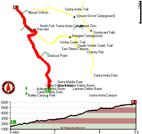
Here in the wonderful state of California hiking is the wonderful thing to do. California is an excellent outdoors state. Mount Wilson |
|
Trail is a long tour away from Los Angeles-Long Beach-Santa Ana, but trekking it is always enjoyable. There are so many hiking trails in this vicinity. The length of this wilderness trail is on the longer side with an average amount of climbing distance which makes this a very
| | tough hiking trail for advanced hikers looking for a tremendous challenge. Different parts of this hiking trail are at very different elevations which of course means you need to be prepared for different conditions on different parts of the hiking trail. Please follow all local rules about fires and camping. Gotta get out of the city man, and Mount Wilson Trail in Los Angeles County, California is just the place. This wilderness hiking trail has a total elevation difference of 4,576 feet, and that is higher than average. Mount Wilson Trail is a glorious | |
|
place of typical precipitation; the month of February is the wettest with most of the rain, and July is the month with the least moisture. At parts of the year this area sees very little rain, so do check for current fire restrictions before you go if you plan to bring a stove
or make a camp fire. This is a wilderness trail that is quite long, so do pack enough food to last the whole trip. Mount Wilson Trail is 11.2 miles long; it's a long hiking trail. Of course, this is an overnight backcountry hike, 1.5 days normally, so better have big backpack to
fit all the stuff you need. There are many wonderful backcountry hiking trails in California, and one of those is Mount Wilson Trail in Los Angeles County. Mount Wilson Trail has two trailheads, so trekking it one way is an option if you can arrange for a ride back. Summertime
at Mount Wilson Trail comes with high temperatures in the 80's. When the night sets in temperatures sink down into the 60's. All through the wintertime this place gets highs in the 50's; winter nights come with lows in the 30's to Mount Wilson Trail. Backpacking and hiking trails
like this one here in the San Gabriel Mountains are a very splendid way to see these peaks. Each one of the many backcountry hiking trails of California has its own unique attractiveness.
Briefly about the general area: There's so much to do here at Mount Wilson Trail
that you need to camp here for a while, Hoegee Campground is a perfect spot for that; Sturtevant Falls is always fun to check out. Winter Creek is a good place to take a look at, and you ought to absolutely dedicate some time to Carter Debris Basin if you're here at Mount Wilson
Trail. Yeah, come up here to the San Gabriel Mountains for a great time. If you came to camp Spruce Grove Campground is a splendid place to do that, and an out of the ordinary thing to visit near Mount Wilson Trail is Carter Debris Dam. Be careful coming to the San Gabriel
Mountains, you might not ever wanna go home again. Some of the water close by flows, like Harvard Branch, and don’t forget to have a look at Auburn Debris Basin while you're here at Mount Wilson Trail. Man, is there a heap of cool things to do near Mount Wilson Trail. A splendid
spot near Mount Wilson Trail is Bailey Canyon, and Mount Wilson Trail is a location with many visitors from Los Angeles-Long Beach-Santa Ana.
|
|
Location of Trailhead 1: Latitude 34.1737, Longitude -118.0469 - - Directions and Road Map
Location of Trailhead 2: Latitude 34.227, Longitude -118.0676 - - Directions and Road Map

Trailhead 1 to Trailhead 2: Total hiking length = 5.6 miles Total climbing distance = 3.9 miles Difficulty : Difficult Casual Hiking Pace:
6 hours
Fast Hiking Pace:
3.5 hours
Trailhead 2 to Trailhead 1: Total hiking length = 5.6 miles Total climbing distance = .8 miles Difficulty : Easy Casual Hiking Pace:
4 hours
Fast Hiking Pace:
2 hours
| | Trailhead 1 back to Trailhead 1: Total hiking length = 11.2 miles Total climbing distance = 4.7 miles Difficulty : Difficult Casual Hiking Pace:
1.5 days
Fast Hiking Pace:
6.5 hours
Trailhead 2 back to Trailhead 2: Total hiking length = 11.2 miles Total climbing distance = 4.7 miles Difficulty : Difficult Casual Hiking Pace:
1.5 days
Fast Hiking Pace:
6.5 hours
|
Total elevation difference: 4576 feet

|
| |
Best Western Pasadena Royale, Pasadena
|
3 miles away
Enjoy affordable luxury at this full-service Pasadena, California hotel located minutes away from the Rose Bowl, the Los Angeles Arboretum and the Santa Anita Race Track. Welcome to the Best Western...
|
|
User input for Mount Wilson Trail, San Gabriel Mountains, Los Angeles County, California:

Outdoors Recreation Near Los Angeles-Long Beach-Santa Ana, California Very comprehensive list of a variety of outdoors recreation in the vicinity of Los Angeles-Long Beach-Santa Ana, California, the metro area neareast to Mount Wilson Trail. Find info on campgrounds, hiking trails, ski resorts, lakes, beaches, parks, whitewater and more.
More Hotels and Campgrounds Near Mount Wilson Trail, San Gabriel Mountains, Los Angeles County, California
| |
| |
 |
|
| These outdoors activities are available near Mount Wilson Trail. |
| | Trails Near Mount Wilson Trail:
 |
Winter Creek Trail, Los Angeles
County
, 1 miles away, 3.2 hiking miles, 2924 feet elevation difference |
 |
Upper Winter Creek Trail, Los Angeles
County
, 2 miles away, 4.8 hiking miles, 3976 feet elevation difference |
 |
Santa Anita Trail, Los Angeles
County
, 2 miles away, 4.2 hiking miles, 2891 feet elevation difference |
 |
Idlehour Trail, Los Angeles
County
, 3 miles away, 6.2 hiking miles, 2028 feet elevation difference |
 |
Valley Forge Trail, Los Angeles
County
, 3 miles away, 3.2 hiking miles, 1606 feet elevation difference |
 |
Gabrielino National Scenic Trail, Los Angeles
County
, 4 miles away, 19.9 hiking miles, 3843 feet elevation difference |
 |
Condor Peak Riding and hiking Trail, Los Angeles
County
, 12 miles away, 8.6 hiking miles, 3552 feet elevation difference |
|
| | Hotels Near Mount Wilson Trail:
 |
Days Inn Pasadena, Pasadena
, 3 miles away |
 |
Best Western Pasadena Royale, Pasadena
, 3 miles away |
 |
Best Western Pasadena Inn, Pasadena
, 3 miles away |
 |
Holiday Inn Express Hotel & Suites Pasadena, Ca-Colorado Blvd., Pasadena
, 3 miles away |
 |
Santa Anita Inn, Arcadia
, 4 miles away |
|
|
|
 |
|