| |
This backcountry trail has a total elevation difference of 2,630 feet which is higher than average. Different parts of Mount Lola Trail are at very different elevations, so keep in mind that you may need to dress differently at different elevations. Sometimes this backpacking trail gets really dry, so don’t forget to check for any current fire restrictions before you go. Now, this is roughly a 2-day hike, so make sure you've got all your overnight gear packed. This is a two-ended backcountry trail with two trailheads, so hiking it one way is an option if you can arrange for a ride back. With its 14.4 miles of walking distance; it's considered a longer backcountry hike. Keep in mind that this is a long backpacking trail, so make sure you bring plenty of supplies.
|
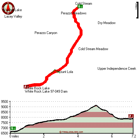
Trailhead 1 to Trailhead 2:
Total hiking length = 7.2 miles
Total climbing distance = 4.6 miles
Difficulty : Difficult
Casual Hiking Pace:
7.5 hours
Fast Hiking Pace:
4 hours
Trailhead 2 to Trailhead 1:
Total hiking length = 7.2 miles
Total climbing distance = 1.6 miles
Difficulty : Difficult
Casual Hiking Pace:
5.5 hours
Fast Hiking Pace:
3 hours
| | Trailhead 1 back to Trailhead 1:
Total hiking length = 14.4 miles
Total climbing distance = 6.2 miles
Difficulty : Difficult
Casual Hiking Pace:
2 days
Fast Hiking Pace:
8.5 hours
Trailhead 2 back to Trailhead 2:
Total hiking length = 14.4 miles
Total climbing distance = 6.2 miles
Difficulty : Difficult
Casual Hiking Pace:
2 days
Fast Hiking Pace:
8.5 hours
|
Total elevation difference: 2630 feet
|


