California hiking trails - Monte Arido Trail, Sierra Madre, Ventura County

   
  Backcountry trekking in California is always a fun thing to do. A lengthy drive divides Oxnard-Thousand Oaks-Ventura from Monte Arido Trail, but when you backcountry walk it you're always having a wonderful time. Each one of the many backcountry hiking trails of California has something unique to offer. This is one of many backpacking and hiking trails in the surrounding neighborhood. The backpacking trail stays roughly within the same elevation zone the whole time, so you won’t have to worry about different climate zones along your walk. Monte Arido
    Trail has only one trailhead, so in and out is the way to trek it normally. Summertime brings highs in the 90's to Monte Arido Trail, and during the night it cools down to the 50's. During the wintertime highs are frequently in the 60's while Monte Arido Trail nighttime low temperatures
during the wintertime are in the 30's. The great outdoors hiking trails of the Sierra Madre are a very glorious way to see these highlands. This is not a very long backcountry trail but you should still bring some emergency supplies just in case something happens. With its 1.8 miles of walking distance it's a shorter type walk. You should count on this trek taking about 1.5 hours, but you never know stuff could go wrong and you could get stuck so be prepared for that. Monte Arido Trail gets very little rainfall; the month with most of the rain is February,  
and July is the month with the least moisture. At parts of the year this vicinity sees very little rain, so make sure you check current conditions and fire restrictions with local forest authorities before you head out. This great outdoors hiking trail is a very short great outdoors hiking trail with an average amount of climbing distance which makes it an outstanding backpacking and hiking trail for the average person looking for an outstanding adventure. When was the last time you got out in nature a bit? Monte Arido Trail in Ventura County, California is a wonderful pick. Don’t forget to check for any current restrictions or closures before you go. The total elevation difference for this hiking trail is 1,244 feet which is an average number. If you are in California during backcountry trekking season you have to go backcountry trekking. Tremendous backcountry hiking trails in California are in abundance, and Monte Arido Trail is one of them, and it's in Ventura County.

Briefly about the general area:
You'll in fact wish for more hours in a day to enjoy all the cool stuff in the Sierra Madre. Nearby Murietta Divide is a great place to go if you're at Monte Arido Trail. There's so much to do here at Monte Arido Trail that you need to camp here for a while, Ventura Oaks RV Park is a splendid location for that. Here at Monte Arido Trail you'll in all probability meet some people from Oxnard-Thousand Oaks-Ventura.
All our national parks are great places to have a look at, and Channel Islands National Park is no exception. You'll need more than a day to discover everything Monte Arido Trail has to offer, you can camp at Murietta Campground.

Location of Trailhead: Latitude 34.4908, Longitude -119.436
- - Directions and Road Map

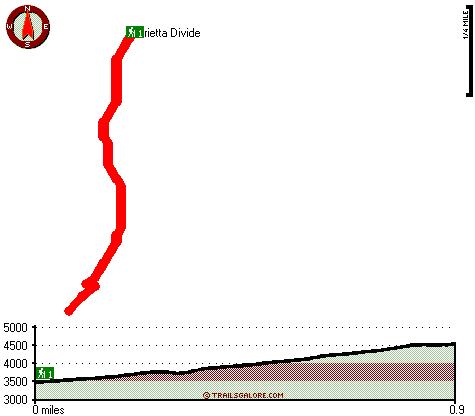
Total in and out hiking length = 1.8 miles

Total climbing distance = .7 miles

Difficulty : Medium

Casual Hiking Pace: 1.5 hours

Fast Hiking Pace: 1 hours

Total elevation difference: 1244 feet


Holiday Inn Express Hotel & Suites Carpinteria, Carpinteria
7 miles away
The Holiday Inn Express Hotel & Suites Carpinteria welcomes you! Our warm coastal community has one of the most beautiful and highly rated beaches in the country. Whether all day with the family or af...
  
Best Western Carpinteria Inn, Carpinteria
8 miles away
Stay at this Carpinteria, California hotel and enjoy the scenic countryside and the world's safest beaches. The Best Western Carpinteria Inn is conveniently located with easy access to key area attr...
User input for Monte Arido Trail, Sierra Madre, Ventura County, California:

Submit Input:
Your Name:
Write or Paste Input here:

Upload picture:      Review Guidelines


Outdoors Recreation Near Oxnard-Thousand Oaks-Ventura, California
Very comprehensive list of a variety of outdoors recreation in the vicinity of Oxnard-Thousand Oaks-Ventura, California, the metro area neareast to Monte Arido Trail. Find info on campgrounds, hiking trails, ski resorts, lakes, beaches, parks, whitewater and more.

Current weather conditions at Monte Arido Trail, Sierra Madre, Ventura County, California
WXPort

Local climate location: CACHUMA LAKE 13 miles away

Sandyland Reef Inn, Carpinteria
8 miles away
Located conveniently close to the beach and visible from Freeway 101, Sandyland Reef Inn is beautifully built with Santa Barbara charm. Just 1 mile from downtown Carpinteria and 10 miles South of Sant...

Oakridge Inn, Ojai
11 miles away
A great get-away Inn, offering 33 newly renovated spacious rooms in a quiet, comfortable, and friendly small town environment in the beautiful Ojai Valley. Oak View, part of the Ojai Valley, is ...

More Hotels and Campgrounds Near Monte Arido Trail, Sierra Madre, Ventura County, California

OTHER_INFO
  Sierra Madre Campgrounds
Complete list of all the campgrounds in the Sierra Madre.

Sierra Madre Outdoors Info
Complete outdoors info for the Sierra Madre.

California Hiking Trails
Complete list of all hiking trails in California

Books about hiking trails in California
List of books available on Amazon.com about hiking trails in California.

California Outdoors Index
This is a very comprehensive index of outdoors activities in the great state of California.


TOPO
High quality water resistant topo map of Monte Arido Trail, Sierra Madre, Ventura County, California.

OUTDOORS_GUIDE
These outdoors activities are available near Monte Arido Trail.
 Trails Near Monte Arido Trail:
Rincon Trail, Santa Barbara County , 2 miles away,  11.6 hiking miles, 4654 feet elevation difference
Ocean View Trail, Ventura County , 3 miles away,  8.8 hiking miles, 1017 feet elevation difference
Steer Creek Trail, Santa Barbara County , 4 miles away,  7.8 hiking miles, 1010 feet elevation difference
Franklin Trail, Santa Barbara County , 5 miles away,  8 hiking miles, 2209 feet elevation difference
Coyote Trail, Ventura County , 5 miles away, 3.2 hiking miles, 2072 feet elevation difference
Agua Caliente Trail, Santa Barbara County , 8 miles away,  17 hiking miles, 2537 feet elevation difference
Ortega Trail, Ventura County , 8 miles away,  18.2 hiking miles, 1624 feet elevation difference
 Camp Grounds Near Monte Arido Trail:
Murietta Campground, Ventura County, 3 miles away
Ventura Oaks RV Park, Ojai, 3 miles away
Alder Creek Campground, Santa Barbara County, 4 miles away
Middle Matilija Campground, Ventura County, 6 miles away
Upper Matilija Campground, Ventura County, 7 miles away
 National Parks Near Monte Arido Trail:
Channel Islands National Park, Ventura - CA , 15 miles away
Santa Monica Mountains National Recreation Area, Thousand Oaks - CA , 42 miles away
 Hotels Near Monte Arido Trail:
Holiday Inn Express Hotel & Suites Carpinteria, Carpinteria , 7 miles away
Best Western Carpinteria Inn, Carpinteria , 8 miles away
Sandyland Reef Inn, Carpinteria , 8 miles away
Oakridge Inn, Ojai , 11 miles away
Emerald Iguana Inn, Ojai , 11 miles away
 Lakes Near Monte Arido Trail
Jameson Lake, Santa Barbara County , 5 miles away

Outdoors related information copyright © Stratus-Pikpuk, Inc. - Detailed hotel information copyright © Interactive Hotel Solutions