| |
The total elevation difference for Mono Alamar Trail is 1,332 feet which is about average. At parts of the year this vicinity sees very little rain, so don’t forget to check for any current fire restrictions before you go. Mono Alamar Trail is quite long, so don't forget to pack enough supplies. The time needed for this backcountry walk is roughly 8 hours, but of course some people walk a bit slower and some a bit faster. With its 9.4 miles of walking distance; it's a long hiking trail. There's not much difference in elevation along the hiking trail which means the conditions are about the same from start to finish. This hiking and backpacking trail has only one trailhead, so you're looking at an in and out trek.
|
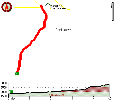
Total in and out hiking length = 9.4 miles
Total climbing distance = 3.8 miles
Difficulty : Difficult
Casual Hiking Pace:
8 hours
Fast Hiking Pace:
5.5 hours
Total elevation difference: 1332 feet
|


