| |
There are two trailheads to chose from, one in each end which means you have the option of backcountry trekking it one way if you have someone to pick you up at the other end. With its 23 miles of walking distance; it's longer than many trails. The trail stays roughly within the same elevation zone the whole time, so you won’t have to worry about different climate zones along your hike. Now, this is roughly a 3.5-day walk, so make sure you've got all your overnight gear packed. Now this great outdoors hiking trail is pretty long, so don't forget to pack enough supplies. This backpacking and hiking trail has a total elevation difference of 1,328 feet, and that is about average. Sometimes this great outdoors hiking trail gets really dry, so don’t forget to check for any current fire restrictions before you go.
|
Trailhead 1 to Trailhead 2:
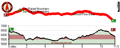
Total hiking length = 11.5 miles
Total climbing distance = 4.7 miles
Difficulty : Difficult
Casual Hiking Pace:
1.5 days
Fast Hiking Pace:
5.5 hours
Trailhead 2 to Trailhead 1:
Total hiking length = 11.5 miles
Total climbing distance = 6.2 miles
Difficulty : Difficult
Casual Hiking Pace:
2 days
Fast Hiking Pace:
6 hours
| | Trailhead 1 back to Trailhead 1:
Total hiking length = 23 miles
Total climbing distance = 10.9 miles
Difficulty : Difficult
Casual Hiking Pace:
3.5 days
Fast Hiking Pace:
2.5 days
Trailhead 2 back to Trailhead 2:
Total hiking length = 23 miles
Total climbing distance = 10.9 miles
Difficulty : Difficult
Casual Hiking Pace:
3.5 days
Fast Hiking Pace:
2.5 days
|
Total elevation difference: 1328 feet
|


