California hiking trails - Middle Sespe Trail, Sierra Madre, Ventura County

   
  Hey, time for a backcountry walk don’t you think? if you happen to be in Ventura County of California, Middle Sespe Trail is a good local trail for doing a bit of leg stretching. Great outdoors trails for backcountry hiking, and backpacking can be found all over California; one of those is Middle Sespe Trail in Ventura County. It's a lengthy drive from Oxnard-Thousand Oaks-Ventura to Middle Sespe Trail, but it is an enjoyable place to backcountry walk. With so many outdoors pursuits available in California you'll never get bored. Sometimes this backcountry
    trail gets really dry, so don’t forget to check for any current fire restrictions before you go. There's not much difference in elevation along the hiking and backpacking trail, so you won’t have to worry about different climate zones along your trek. This is a two-ended wilderness
hiking trail with two trailheads, so if you can get a ride from someone, you can backcountry hike it just one way. This is a long backcountry trail, so make sure you bring plenty of supplies. There are plenty of hiking trails in California; each one of them has its own character. The length of Middle Sespe Trail is about average with an average amount of climbing distance which makes it a glorious wilderness trail for experienced walkers in great shape. The backpacking and hiking trails of the Sierra Madre are the best way to enjoy these mountains. Middle  
Sespe Trail has a total elevation difference of 314 feet which is a lower than average number. Please follow all local rules about fires and camping. This backcountry trek shouldn't take more than 5.5 hours, but you never know stuff could go wrong and you could get stuck so be prepared for that. Middle Sespe Trail is an excellent site of typical rain; through February this region sees the most rain, and the driest of the months is July. This is one of many wilderness trails in the surrounding area. Here in California backcountry hiking is an outstanding way to spend some time. For the duration of the summer at Middle Sespe Trail temperatures are commonly in the 90's with overnight lows in the 50's. Daytime highs all through the wintertime are in the 60's, and overnight lows at Middle Sespe Trail all through the wintertime mostly plunge into the 30's. Middle Sespe Trail is 6.4 miles long it's an average length hiking and backpacking trail.

Briefly about the general area:
Stay the night at Middle Lion Campground; nearby you find Rose Valley which is a brilliant location to stop by. If time allows, Channel Islands National Park is a national park worth a visit, and a short trip to Rose Valley Falls is always worthwhile.
Life's too short to enjoy all the exciting things in the Sierra Madre. Howard Creek is close to Middle Sespe Trail and is always a pleasure to stop at, and Middle Sespe Trail is a pleasant location to visit for more than one day, Rose Valley Campground is a pleasant location to camp nearby. Just can't get enough of Middle Sespe Trail. Get yourself into a kayak and hit Sespe Creek, and Rock Creek is one of the streams nearby that might be worth going to.

Location of Trailhead 1: Latitude 34.5567, Longitude -119.1997
- - Directions and Road Map

Location of Trailhead 2: Latitude 34.5545, Longitude -119.2449
- - Directions and Road Map


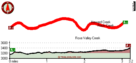
Trailhead 1 to Trailhead 2:
Total hiking length = 3.2 miles
Total climbing distance = 1.9 miles
Difficulty : Medium
Casual Hiking Pace: 3 hours
Fast Hiking Pace: 2 hours

Trailhead 2 to Trailhead 1:
Total hiking length = 3.2 miles
Total climbing distance = .9 miles
Difficulty : Easy
Casual Hiking Pace: 2.5 hours
Fast Hiking Pace: 1.5 hours
    Trailhead 1 back to Trailhead 1:
Total hiking length = 6.4 miles
Total climbing distance = 2.8 miles
Difficulty : Difficult
Casual Hiking Pace: 5.5 hours
Fast Hiking Pace: 3.5 hours

Trailhead 2 back to Trailhead 2:
Total hiking length = 6.4 miles
Total climbing distance = 2.8 miles
Difficulty : Difficult
Casual Hiking Pace: 5.5 hours
Fast Hiking Pace: 3.5 hours

Total elevation difference: 314 feet


Best Western Casa Ojai, Ojai
7 miles away
Enjoy convenient access to Lake Casitas and Los Padres National Forest while staying at this Ojai, California hotel. Welcome to the Best Western Casa Ojai where guests will be treated to superior ser...
  
Hummingbird Inn, Ojai
7 miles away
Welcome to the Hummingbird Inn of Ojai, California ,awarded THREE DIAMOND hotel accommodations by AAA. The Ojai Mountain Valley is one of Southern California's truly wonderful tourist destinations. Fi...
User input for Middle Sespe Trail, Sierra Madre, Ventura County, California:

Submit Input:
Your Name:
Write or Paste Input here:

Upload picture:      Review Guidelines


Outdoors Recreation Near Oxnard-Thousand Oaks-Ventura, California
Very comprehensive list of a variety of outdoors recreation in the vicinity of Oxnard-Thousand Oaks-Ventura, California, the metro area neareast to Middle Sespe Trail. Find info on campgrounds, hiking trails, ski resorts, lakes, beaches, parks, whitewater and more.

Current weather conditions at Middle Sespe Trail, Sierra Madre, Ventura County, California
WXPort

Local climate location: OJAI 16 miles away

The Capri, Ojai
7 miles away
Nestled in the Ojai Valley, Our Limited Luxury Boutique hotel is designed for the discerning traveler who has high expectations of comfort, without the high price. Whether you choose the Mountain view...

Su Nido Inn, Ojai
7 miles away
Su Nido was designed not just as a place to stay but as an oasis experience for you- an escape from the ordinary; hence the name- which means your nest in Spanish. Located in the heart of the colorful...

More Hotels and Campgrounds Near Middle Sespe Trail, Sierra Madre, Ventura County, California

OTHER_INFO
  Sierra Madre Campgrounds
Complete list of all the campgrounds in the Sierra Madre.

Sierra Madre Outdoors Info
Complete outdoors info for the Sierra Madre.

California Hiking Trails
Complete list of all hiking trails in California

Books about hiking trails in California
List of books available on Amazon.com about hiking trails in California.

California Outdoors Index
This is a very comprehensive index of outdoors activities in the great state of California.


TOPO
High quality water resistant topo map of Middle Sespe Trail, Sierra Madre, Ventura County, California.

OUTDOORS_GUIDE
These outdoors activities are available near Middle Sespe Trail.
 Trails Near Middle Sespe Trail:
Rose Lion Trail, Ventura County , 3 miles away, 5.6 hiking miles, 2160 feet elevation difference
Piedra Blanca National Recreation Trail, Ventura County , 4 miles away, 9.5 hiking miles, 2662 feet elevation difference
Horn Canyon Trail, Ventura County , 5 miles away, 2.9 hiking miles, 3157 feet elevation difference
Cedar Lake Trail, Ventura County , 6 miles away, 4.7 hiking miles, 2058 feet elevation difference
Pratt Trail, Ventura County , 6 miles away, 5.3 hiking miles, 2337 feet elevation difference
Foothill Trail, Ventura County , 6 miles away, 1.7 hiking miles, 679 feet elevation difference
Cozy Dell Trail, Ventura County , 7 miles away, 1.5 hiking miles, 780 feet elevation difference
 Camp Grounds Near Middle Sespe Trail:
Rose Valley Campground, Ventura County, 2 miles away
Middle Lion Campground, Ventura County, 3 miles away
Lion Campground, Ventura County, 3 miles away
Beaver Campground, Ventura County, 4 miles away
Three Mile Campground, Ventura County, 4 miles away
 Whitewater Near Middle Sespe Trail:
Sespe Creek, Ventura County County , 11 miles away, Class IV-V - 31.5 miles long (Lion Campground to Highway 126 bridge)
 National Parks Near Middle Sespe Trail:
Channel Islands National Park, Ventura - CA , 17 miles away
Santa Monica Mountains National Recreation Area, Thousand Oaks - CA , 30 miles away
 Hotels Near Middle Sespe Trail:
Best Western Casa Ojai, Ojai , 7 miles away
Hummingbird Inn, Ojai , 7 miles away
The Capri, Ojai , 7 miles away
Su Nido Inn, Ojai , 7 miles away
Ojai Rancho Inn, Ojai , 7 miles away
 Lakes Near Middle Sespe Trail
Lower Rose Lake, Ventura County , 1 miles away
Upper Rose Lake, Ventura County , 2 miles away

Outdoors related information copyright © Stratus-Pikpuk, Inc. - Detailed hotel information copyright © Interactive Hotel Solutions