California hiking trails - Mammoth Rock Trail, Central Sierra Nevada, Mono County

   
  Hiking and backpacking trails are delightful and plentiful in California; Mammoth Rock Trail in Mono County is one of them. Far from society you locate Mammoth Rock Trail, and when you walk it you're always having a splendid time. You can't spend all your time indoors you need to get out once in a while, and Mammoth Rock Trail in Mono County, California is the wilderness at its best. This vicinity does get very dry sometimes, so make sure you check current conditions and fire restrictions with local forest authorities before you head out. Hiking here
    in California is so much fun. Backcountry trekking here in the Central Sierra Nevada is a very fine way to see these mountaintops. This is not a very long backpacking and hiking trail but you should still bring some emergency supplies just in case something happens. While visiting
this region in California it's a splendid idea to go backcountry backpacking too. There's not much difference in elevation along Mammoth Rock Trail, so you won’t have to worry about different climate zones along your hike. At Mammoth Rock Trail you don’t see much precipitation; the wettest month of the year is frequently January, that's the one that rains the most, and the driest month is June. You should count on this backcountry trek taking about 5 hours, but of course some folks walk a bit slower and some a bit faster. All through the long summer days  
highs here at Mammoth Rock Trail get into the 90's. For the duration of the dark hours of summer temperatures fall down into the 50's. Daytime highs through the winter are in the 40's, and winter nights come with lows in the 20's to Mammoth Rock Trail. With its 5.6 miles of walking distance it's an average length hiking trail. This is one of a very small number of wilderness trails in this neighborhood. The total elevation difference for Mammoth Rock Trail is 1,224 feet which is about average. Mammoth Rock Trail is a two ended backpacking and hiking trail with two trailheads, so backcountry hiking it one way is an option if you can arrange for a ride back. Mammoth Rock Trail is a mid-length hiking trail with an average amount of climbing distance which makes it a fine wilderness trail for the average person looking for a fine adventure. Every backcountry hiking trail in California has something unique to offer. Don’t forget to check for any current restrictions or closures before you go.

Briefly about the general area:
Visit Sherwin Creek since you're here at Mammoth Rock Trail; Bottomless Pit is a magnificent location to check out. If you come to this river you will have a good time for sure. Cold Water Creek is a brilliant place to stop at, and camping is available at Cold Water Campground.
And that's not all you can do here at Mammoth Rock Trail. All the outdoors entertaining stuff in the Central Sierra Nevada will keep you coming back many times. It's always splendid to pop by Twin Falls, and Sky Meadows is a beautiful place any time of year. All our national parks are wonderful locations to check out, and Devils Postpile National Monument is no exception; if you came for an overnight stay Convict Lake Resort is a good site to camp.

Location of Trailhead 1: Latitude 37.6192, Longitude -118.9928
- - Directions and Road Map

Location of Trailhead 2: Latitude 37.6295, Longitude -118.9601
- - Directions and Road Map


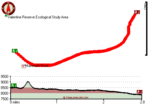
Trailhead 1 to Trailhead 2:
Total hiking length = 2.8 miles
Total climbing distance = .6 miles
Difficulty : Easy
Casual Hiking Pace: 2 hours
Fast Hiking Pace: 1 hours

Trailhead 2 to Trailhead 1:
Total hiking length = 2.8 miles
Total climbing distance = 1.5 miles
Difficulty : Medium
Casual Hiking Pace: 2.5 hours
Fast Hiking Pace: 1.5 hours
    Trailhead 1 back to Trailhead 1:
Total hiking length = 5.6 miles
Total climbing distance = 2.1 miles
Difficulty : Medium
Casual Hiking Pace: 5 hours
Fast Hiking Pace: 3 hours

Trailhead 2 back to Trailhead 2:
Total hiking length = 5.6 miles
Total climbing distance = 2.1 miles
Difficulty : Medium
Casual Hiking Pace: 5 hours
Fast Hiking Pace: 3 hours

Total elevation difference: 1224 feet


Rodeway Inn Sierra Nevada, Mammoth Lakes
Our hotel is located along Highway 395, less than 10 miles from Devils Postpile National Monument, Convict Lake and Crowley Lake. The hotel is close to Rainbow Falls and Hot Creek. Mammoth Lakes Airpo...
  
Mammoth Creek Inn, Mammoth Lakes
The Mammoth Creek Inn is Mammoth?s best-kept secret and a tradition for more than 30 years. Under new ownership, this European-style lodge has kept all of its charm while adding new amenities and serv...
User input for Mammoth Rock Trail, Central Sierra Nevada, Mono County, California:

Submit Input:
Your Name:
Write or Paste Input here:

Upload picture:      Review Guidelines


Outdoors Recreation Near Madera, California
Very comprehensive list of a variety of outdoors recreation in the vicinity of Madera, California, the metro area neareast to Mammoth Rock Trail. Find info on campgrounds, hiking trails, ski resorts, lakes, beaches, parks, whitewater and more.

Current weather conditions at Mammoth Rock Trail, Central Sierra Nevada, Mono County, California
WXPort

Local climate location: YOSEMITE PARK HDQTRS 27 miles away

Juniper Springs Resort, Mammoth Lakes
Juniper Springs Resort is a quiet slope side property that features only condominium style rooms with the feel of a full service Hotel. We offer a full-service guest experience with amenities such as...

Quality Inn Mammoth Lakes, Mammoth Lakes
Walking distance to Outlets, Restaurants, Lounge's. Shuttle to ski lift is located accross the street. 1 to 3 miles from Banks, Stores, and gas stations. On Main Street of Mammoth Lakes, CA. One of t...

More Hotels and Campgrounds Near Mammoth Rock Trail, Central Sierra Nevada, Mono County, California

OTHER_INFO
  Central Sierra Nevada Campgrounds
Complete list of all the campgrounds in the Central Sierra Nevada.

Central Sierra Nevada Outdoors Info
Complete outdoors info for the Central Sierra Nevada.

California Hiking Trails
Complete list of all hiking trails in California

Books about hiking trails in California
List of books available on Amazon.com about hiking trails in California.

California Outdoors Index
This is a very comprehensive index of outdoors activities in the great state of California.


TOPO
High quality water resistant topo map of Mammoth Rock Trail, Central Sierra Nevada, Mono County, California.

OUTDOORS_GUIDE
These outdoors activities are available near Mammoth Rock Trail.
 Trails Near Mammoth Rock Trail:
Sherwin Lakes Trail, Mono County , 3 miles away,  3.4 hiking miles, 954 feet elevation difference
 Camp Grounds Near Mammoth Rock Trail:
Cold Water Campground, Mono County, 2 miles away
Convict Lake Resort, Mammoth Lakes, 3 miles away
Mammoth Mountain RV Park, Mammoth Lakes, 3 miles away
Crowley Lake Campland, Mammoth Lakes, 4 miles away
Inyo Craters Campground, Mono County, 5 miles away
 National Parks Near Mammoth Rock Trail:
Devils Postpile National Monument, Mammoth Lakes - CA , 17 miles away
Yosemite National Park, Yosemite National Park - CA , 47 miles away
Sequoia & Kings Canyon National Park, Three Rivers - CA , 65 miles away
 Hotels Near Mammoth Rock Trail:
Rodeway Inn Sierra Nevada, Mammoth Lakes , 1 miles away
Mammoth Creek Inn, Mammoth Lakes , 1 miles away
Juniper Springs Resort, Mammoth Lakes , 1 miles away
Quality Inn Mammoth Lakes, Mammoth Lakes , 1 miles away
Holiday Inn Hotel & Suites Mammoth Lakes, California, Mammoth Lakes , 2 miles away
 Lakes Near Mammoth Rock Trail
Heart Lake, Mono County , 2 miles away
Arrowhead Lake, Mono County , 2 miles away

Outdoors related information copyright © Stratus-Pikpuk, Inc. - Detailed hotel information copyright © Interactive Hotel Solutions