| |
The total elevation difference for this backpacking trail is 2,173 feet, and that is about average. Even though this is not a very long hiking trail it's always pleasant to bring some emergency supplies, you never know what could happen. Magee Trail is 6 miles long it's an average length backcountry trail. This backcountry walk shouldn't take more than 5.5 hours, but of course some folks walk a bit slower and some a bit faster. This backpacking trail has only one trailhead, so in and out is the way to hike it normally. Some parts of Magee Trail are much higher up than other parts of the backcountry trail which of course means you need to be prepared for different conditions on different parts of the backcountry trail. Sometimes this hiking trail gets really dry, so make sure you check current conditions and fire restrictions with local forest authorities before you head out.
|
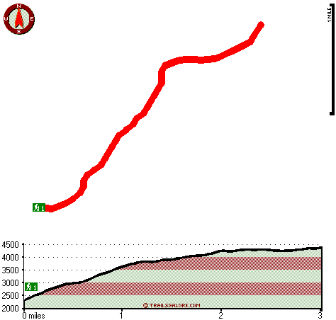
Total in and out hiking length = 6 miles
Total climbing distance = 2.5 miles
Difficulty : Difficult
Casual Hiking Pace:
5.5 hours
Fast Hiking Pace:
3.5 hours
Total elevation difference: 2173 feet
|


