California hiking trails - Long Valley Trail, Northern Sierra Nevada, Placer County

   
  With so many outdoors things to do available in California you'll never get bored. Hiking trails for hiking, and backpacking can be found all over California, and Long Valley Trail in Placer County is one of them. If you happen to be in California, why not go hiking, it is so much fun. The high level of precipitation makes Long Valley Trail a rather wet site; of all the months in a year January is the one with the most rain, and the driest month is July. Summertime highs at Long Valley Trail typically tend to be in the 70's with night lows in the 50's.
    The wintertime brings highs down to the 40's; after the sun is down all through the wintertime temperatures at Long Valley Trail fall into the 20's. The length of this backpacking trail is about average with an average amount of climbing distance which makes it an excellent trail
for the average person looking for an excellent adventure. This is not a very long backcountry hiking trail but it's always wonderful to bring some emergency supplies, you never know what could happen. Long Valley Trail has a total elevation difference of 816 feet which is a lower than average number. This is just one of a large number of trails in this area. We all need to get out in nature once in a while, and Long Valley Trail in Placer County, California is a magnificent place to go. It's a long journey from Truckee-Grass Valley to Long Valley Trail,  
but backpacking along this wilderness trail is very enjoyable. This hiking trail has only one trailhead, so you're looking at an in and out backcountry trek. Please follow all local rules about fires and camping. Being 5.6 miles long it's a mid length backcountry trek. Every hiking and backpacking trail in California is different from the others. The wonderful backpacking trails of the Northern Sierra Nevada are a nice way to explore these highlands. This region does get very dry sometimes, so don’t forget to check for any current fire restrictions before you go. The wilderness trail stays roughly within the same elevation zone the whole time, so you won’t have to worry about different climate zones along your backcountry trek. The time needed for this hike is roughly 5 hours, but of course some people walk a bit slower and some a bit faster.

Briefly about the general area:
Life's too short to enjoy all the amusing things next to Long Valley Trail. Nearby Long Valley is a nice spot to go if you're at Long Valley Trail, and don't forget to take a pleasant little journey to Wabena Creek.
Camping at Cold Springs Campground is always a magnificent experience, and do check out Palisade Creek if you're here at Long Valley Trail. Whitewater paddling is nice on Yuba River - South Fork; a visit to Long Valley Trail wouldn't be complete without taking a look at Heath Spring. And that's not all you can do here in the Northern Sierra Nevada. Paddling on Fordyce Creek is so much fun, and camping is available at Onion Creek Campground.

Location of Trailhead: Latitude 39.3017, Longitude -120.435
- - Directions and Road Map

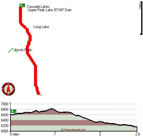
Total in and out hiking length = 5.6 miles

Total climbing distance = 2.4 miles

Difficulty : Medium

Casual Hiking Pace: 5 hours

Fast Hiking Pace: 3 hours

Total elevation difference: 816 feet


Plumpjack Squaw Valley Inn, Olympic Valley
14 miles away
60 room boutique hotel on 3 levels with 5 unique suites. Ski on-ski off property nestled at base of Squaw Valley USA ski resort. We feature two restaurants our own ski rental shop The Inn Shop and bou...
  
Squaw Valley Lodge, Squaw Valley
14 miles away
The Squaw Valley Lodge is Squaw Valleys Four Diamond awarded condominium suites resort; featuring world-class amenities and a true slope-side location; convenient to all of the areas activities. Nestl...
User input for Long Valley Trail, Northern Sierra Nevada, Placer County, California:

Submit Input:
Your Name:
Write or Paste Input here:

Upload picture:      Review Guidelines


Outdoors Recreation Near Truckee-Grass Valley, California
Very comprehensive list of a variety of outdoors recreation in the vicinity of Truckee-Grass Valley, California, the metro area neareast to Long Valley Trail. Find info on campgrounds, hiking trails, ski resorts, lakes, beaches, parks, whitewater and more.

Current weather conditions at Long Valley Trail, Northern Sierra Nevada, Placer County, California
WXPort

Local climate location: BOWMAN DAM 3 miles away

Village at Squaw Valley, Olympic Valley
15 miles away
The Village at Squaw Valley USA is an enchanting pedestrian village located at the base of Squaw Valley USA with approximately 300 condominium suites and a variety of boutique shops, restaurants, and ...

Holiday Inn Express Truckee, Ca, Truckee
15 miles away
The Holiday Inn Express Truckee Hotel is an conveniently located in Truckee, California a recreational paradise, surrounded by lakes and beautiful mountains. We are within minutes to various ski re...

More Hotels and Campgrounds Near Long Valley Trail, Northern Sierra Nevada, Placer County, California

OTHER_INFO
  Northern Sierra Nevada Campgrounds
Complete list of all the campgrounds in the Northern Sierra Nevada.

Northern Sierra Nevada Outdoors Info
Complete outdoors info for the Northern Sierra Nevada.

California Hiking Trails
Complete list of all hiking trails in California

Books about hiking trails in California
List of books available on Amazon.com about hiking trails in California.

California Outdoors Index
This is a very comprehensive index of outdoors activities in the great state of California.


TOPO
High quality water resistant topo map of Long Valley Trail, Northern Sierra Nevada, Placer County, California.

OUTDOORS_GUIDE
These outdoors activities are available near Long Valley Trail.
 Trails Near Long Valley Trail:
Heath Falls Overlook Trail, Placer County , 2 miles away, 5.2 hiking miles, 1601 feet elevation difference
Tevis Cup Trail, Placer County , 4 miles away, 11.1 hiking miles, 1773 feet elevation difference
Sailor Flat Trail, Placer County , 5 miles away,  7.6 hiking miles, 2534 feet elevation difference
Cherry Point Trail, Placer County , 5 miles away, 5.3 hiking miles, 1079 feet elevation difference
Lola Montez Trail, Nevada County , 5 miles away, 1.5 hiking miles, 458 feet elevation difference
Loch Leven Trail, Placer County , 5 miles away,  4.4 hiking miles, 1191 feet elevation difference
Salmon Lake Trail, Placer County , 6 miles away,  3.6 hiking miles, 330 feet elevation difference
 Camp Grounds Near Long Valley Trail:
Cold Springs Campground, Nevada County, 4 miles away
Onion Creek Campground, Placer County, 5 miles away
Van Norden Campground, Nevada County, 6 miles away
Talbot Campground, Placer County, 6 miles away
Ahart Campground, Placer County, 6 miles away
 Whitewater Near Long Valley Trail:
Yuba River - South Fork, Nevada/ Placer County County , 5 miles away, Class IV-V - 5.2 miles long (Kingvale to Cisco Grove)
Fordyce Creek, Nevada County County , 10 miles away, Class IV-V - 12 miles long (Fordyce Lake to Lake Spaulding)
Yuba River - South Fork, Nevada/ Placer County County , 11 miles away, Class IV-V(V+) - 7.5 miles long (Cisco Grove to Spaulding Reservoir)
 Hotels Near Long Valley Trail:
Plumpjack Squaw Valley Inn, Olympic Valley , 14 miles away
Squaw Valley Lodge, Squaw Valley , 14 miles away
Village at Squaw Valley, Olympic Valley , 15 miles away
Holiday Inn Express Truckee, Ca, Truckee , 15 miles away
The Inn At Truckee, Truckee , 16 miles away
 Lakes Near Long Valley Trail
Huntley Mill Lake, Placer County , 1 miles away
Long Lake, Placer County , 2 miles away

Outdoors related information copyright © Stratus-Pikpuk, Inc. - Detailed hotel information copyright © Interactive Hotel Solutions