California hiking trails - Lola Montez Trail, Northern Sierra Nevada, Nevada County

   
  Every California hiking and backpacking trail is pretty in its own way. When you're here in California backcountry backpacking along one of its hiking and backpacking trails is always an enjoyable thing to do. As long as you like nature you will like California. Even though this is not a very long backpacking trail you should still bring some emergency supplies just in case something happens. Lola Montez Trail is 3 miles long it's a shorter type trek. A good deal of rainfall falls at Lola Montez Trail; January is when you get the most rain here while July
    is ordinarily the driest month. There are many glorious hiking and backpacking trails in California; among these are Lola Montez Trail in Nevada County. Lola Montez Trail is a long journey away from Truckee-Grass Valley, but it sure is a an excellent backcountry trail. This backcountry
walk shouldn't take more than 2.5 hours, but you never know stuff could go wrong and you could get stuck so be prepared for that. There's not much difference in elevation along Lola Montez Trail, so you get pretty much the same conditions along the whole wilderness trail. Lola Montez Trail is on the short side having an average number of uphill miles which makes it a wonderful wilderness hiking trail for the average person looking for a wonderful adventure. We all need to get out in nature once in a while, and Lola Montez Trail in Nevada County, California  
is nature at its best. This is one of many wilderness hiking trails in the surrounding neighborhood. There are two trailheads to chose from, one in each end, so backcountry hiking it one way is an option if you can arrange for a ride back. This backpacking and hiking trail has a total elevation difference of 458 feet which is lower than average. Please follow all local rules about fires and camping. The hiking trails of the Northern Sierra Nevada are a very nice way to see these highlands. This neighborhood does get very dry sometimes, so don’t forget to check for any current fire restrictions before you go. Summertime highs at Lola Montez Trail typically tend to be in the 80's, and the overnight is rather colder of course, typically in the 50's. Throughout the winter highs are in the 40's with temperatures at Lola Montez Trail dipping down into the 20's during winter nights.

Briefly about the general area:
Life's too short to enjoy all the fun things in the Northern Sierra Nevada. A good location to camp here at Lola Montez Trail is Van Norden Campground; get your pulse rate up on the fine whitewater of Yuba River - South Fork. Why not camp at Cold Springs Campground if you're here at Lola Montez Trail, and a quick visit to Lower Castle Creek is absolutely a pleasant idea.

Location of Trailhead 1: Latitude 39.328, Longitude -120.3899
- - Directions and Road Map

Location of Trailhead 2: Latitude 39.342, Longitude -120.408
- - Directions and Road Map


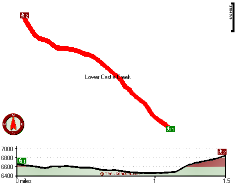
Trailhead 1 to Trailhead 2:
Total hiking length = 1.5 miles
Total climbing distance = .6 miles
Difficulty : Medium
Casual Hiking Pace: 1.5 hours
Fast Hiking Pace: .5 hours

Trailhead 2 to Trailhead 1:
Total hiking length = 1.5 miles
Total climbing distance = .7 miles
Difficulty : Medium
Casual Hiking Pace: 1.5 hours
Fast Hiking Pace: 1 hours
    Trailhead 1 back to Trailhead 1:
Total hiking length = 3 miles
Total climbing distance = 1.3 miles
Difficulty : Medium
Casual Hiking Pace: 2.5 hours
Fast Hiking Pace: 1.5 hours

Trailhead 2 back to Trailhead 2:
Total hiking length = 3 miles
Total climbing distance = 1.3 miles
Difficulty : Medium
Casual Hiking Pace: 2.5 hours
Fast Hiking Pace: 1.5 hours

Total elevation difference: 458 feet


Holiday Inn Express TRUCKEE, Truckee
12 miles away
The Holiday Inn Express Truckee Hotel is an conveniently located in Truckee, California a recreational paradise, surrounded by lakes and beautiful mountains. We are within minutes to various ski re...
  
The Inn at Truckee, Truckee
14 miles away
AAA rated motel centrally located to all Truckee and North Tahoe's outdoor recreational activities. Just minutes to area ski resorts, lakes, hiking trails and mountian biking. Dining and shopping with...
User input for Lola Montez Trail, Northern Sierra Nevada, Nevada County, California:

Submit Input:
Your Name:
Write or Paste Input here:

Upload picture:      Review Guidelines


Outdoors Recreation Near Truckee-Grass Valley, California
Very comprehensive list of a variety of outdoors recreation in the vicinity of Truckee-Grass Valley, California, the metro area neareast to Lola Montez Trail. Find info on campgrounds, hiking trails, ski resorts, lakes, beaches, parks, whitewater and more.

Current weather conditions at Lola Montez Trail, Northern Sierra Nevada, Nevada County, California
WXPort

Local climate location: SIERRA CITY 1 miles away

Plumpjack Squaw Valley Inn, Olympic Valley
14 miles away
60 room boutique hotel on 3 levels with 5 unique suites. Ski on-ski off property nestled at base of Squaw Valley USA ski resort. We feature two restaurants our own ski rental shop The Inn Shop and bou...

Squaw Valley Lodge, Squaw Valley
14 miles away
The Squaw Valley Lodge is Squaw Valleys Four Diamond awarded condominium suites resort; featuring world-class amenities and a true slope-side location; convenient to all of the areas activities. Nestl...

More Hotels and Campgrounds Near Lola Montez Trail, Northern Sierra Nevada, Nevada County, California

OTHER_INFO
  Northern Sierra Nevada Campgrounds
Complete list of all the campgrounds in the Northern Sierra Nevada.

Northern Sierra Nevada Outdoors Info
Complete outdoors info for the Northern Sierra Nevada.

California Hiking Trails
Complete list of all hiking trails in California

Books about hiking trails in California
List of books available on Amazon.com about hiking trails in California.

California Outdoors Index
This is a very comprehensive index of outdoors activities in the great state of California.


TOPO
High quality water resistant topo map of Lola Montez Trail, Northern Sierra Nevada, Nevada County, California.

OUTDOORS_GUIDE
These outdoors activities are available near Lola Montez Trail.
 Trails Near Lola Montez Trail:
Heath Falls Overlook Trail, Placer County , 5 miles away, 5.2 hiking miles, 1601 feet elevation difference
Warren Lake Trail, Nevada County , 5 miles away, 6.6 hiking miles, 2381 feet elevation difference
Long Valley Trail, Placer County , 5 miles away,  5.6 hiking miles, 816 feet elevation difference
Glacier Lakes Trail, Nevada County , 5 miles away, 4.1 hiking miles, 559 feet elevation difference
Mount Lola Trail, Sierra County , 7 miles away, 7.2 hiking miles, 2630 feet elevation difference
Tevis Cup Trail, Placer County , 7 miles away, 11.1 hiking miles, 1773 feet elevation difference
Loch Leven Trail, Placer County , 8 miles away,  4.4 hiking miles, 1191 feet elevation difference
 Camp Grounds Near Lola Montez Trail:
Van Norden Campground, Nevada County, 2 miles away
Cold Springs Campground, Nevada County, 4 miles away
Onion Creek Campground, Placer County, 5 miles away
Sterling Lake Campground, Nevada County, 6 miles away
Talbot Campground, Placer County, 9 miles away
 Whitewater Near Lola Montez Trail:
Yuba River - South Fork, Nevada/ Placer County County , 6 miles away, Class IV-V - 5.2 miles long (Kingvale to Cisco Grove)
 Hotels Near Lola Montez Trail:
Holiday Inn Express TRUCKEE, Truckee , 12 miles away
The Inn at Truckee, Truckee , 14 miles away
Plumpjack Squaw Valley Inn, Olympic Valley , 14 miles away
Squaw Valley Lodge, Squaw Valley , 14 miles away
Village at Squaw Valley, Olympic Valley , 14 miles away
 Lakes Near Lola Montez Trail
Lower Lola Montez Lake, Nevada County , 1 miles away
Buzzard Roost Lake, Nevada County , 2 miles away

Outdoors related information copyright © Stratus-Pikpuk, Inc. - Detailed hotel information copyright © Interactive Hotel Solutions