| |
|
| | Alright, enough of spending all this time inside a building, time to get out, and Lazyman Butte Trail in Tehama County, California is just the place. Backpacking here in California is so much fun. Tremendous wilderness trails in California are in abundance; Lazyman Butte Trail is one of them, and it's in Tehama County. Lazyman Butte Trail goes through some very different elevations, and that means that some parts of the backpacking trail could be very different from other parts of it. For the period of the summer months at Lazyman Butte Trail highs are |
|
generally in the 90's while overnight lows are ordinarily in the 50's. Highs during the wintertime are ordinarily in the 40's, and overnight lows in the 30's for Lazyman Butte Trail. This backcountry hike should take you about 3.5 days, so it's an outstanding thing if your backpack
| | is big enough to do the job. Lazyman Butte Trail is quite long, so do pack enough food to last the whole trip. This vicinity does get very dry sometimes, so do check for current fire restrictions before you go if you plan to bring a stove or make a camp fire. And keep in mind that there could be temporary safety restrictions in place. Every California wilderness trail has something unique to offer. Lazyman Butte Trail is very far from the closest full-scale settlement, and it sure is a a wonderful wilderness trail. There are so many great outdoors trails | |
|
in this area. The hiking and backpacking trails of the Klamath Mountains are the best way to enjoy these mountaintops. This wilderness trail has only one trailhead, so you'll be hiking it in and back out. A typical amount of rain falls here at Lazyman Butte Trail; throughout January
this neighborhood sees the most rain, and July meanwhile is the driest month. A visit to California is not complete without some backcountry backpacking. The length of Lazyman Butte Trail is on the longer side with an average amount of climbing distance which makes it a wonderful
great outdoors trail for experienced backcountry hikers in great shape. This wilderness trail has a total elevation difference of 3,886 feet which is higher than average. Being 24 miles long; it's longer than many backpacking trails.
Briefly about the general area: A
pleasant tour to Devils Hole is a delightful way to spend an afternoon, and if you came for an overnight stay Tomhead Saddle Campground is a pleasant place to camp. It's always delightful to go to Sulphur Spring; Devils Hole Gulch is another tremendous site to pop by nearby.
You completely ought to go for Lazyman Butte Trail. Beegum Creek is a splendid whitewater spot near Lazyman Butte Trail, and a journey to Lazyman Spring will fill your spirit with fine feelings. These mountains rock, just check out all the entertaining stuff to do in the Klamath
Mountains. Cedar Basin is a brilliant place to stretch your legs a bit, and Wells Creek Campground is a wonderful campground here. You truly must love the Klamath Mountains. If you don’t have a problem getting wet, you can always go whitewater paddling on Cottonwood Creek - Middle
Fork, and do check out Willow Creek while you're here at Lazyman Butte Trail. This is such a great river. Deer Creek is a picturesque stream that is worth a visit; Walker Point is not far at all. This river has it all.
|
|
Location of Trailhead: Latitude 40.1706, Longitude -122.9046 - - Directions and Road Map
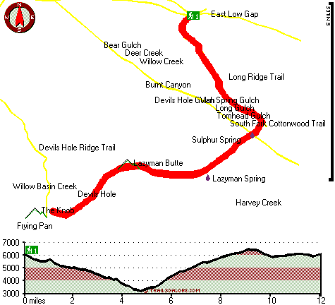
Total in and out hiking length = 24 miles
Total climbing distance = 11.4 miles
Difficulty : Difficult
Casual Hiking Pace:
3.5 days
Fast Hiking Pace:
2.5 days
Total elevation difference: 3886 feet

User input for Lazyman Butte Trail, Klamath Mountains, Tehama County, California:

Outdoors Recreation Near Redding, California Very comprehensive list of a variety of outdoors recreation in the vicinity of Redding, California, the metro area neareast to Lazyman Butte Trail. Find info on campgrounds, hiking trails, ski resorts, lakes, beaches, parks, whitewater and more.
More Hotels and Campgrounds Near Lazyman Butte Trail, Klamath Mountains, Tehama County, California
| |
| |
 |
|
| These outdoors activities are available near Lazyman Butte Trail. |
| | Trails Near Lazyman Butte Trail:
 |
South Fork Cottonwood Trail, Tehama
County
, 2 miles away, 18.8 hiking miles, 4456 feet elevation difference |
 |
Long Ridge Trail, Tehama
County
, 2 miles away, 8.8 hiking miles, 3044 feet elevation difference |
 |
Devils Hole Ridge Trail, Trinity
County
, 4 miles away, 19.2 hiking miles, 633 feet elevation difference |
 |
Ides Cove National Recreation Trail, Tehama
County
, 4 miles away, 12 hiking miles, 1863 feet elevation difference |
 |
North Yolla Bolly Cold Fork Trail, Tehama
County
, 5 miles away, 7.7 hiking miles, 2276 feet elevation difference |
 |
Pettijohn Trail, Tehama
County
, 6 miles away, 11 hiking miles, 1535 feet elevation difference |
 |
French Trail, Mendocino
County
, 6 miles away, 6 hiking miles, 1080 feet elevation difference |
|
| | Whitewater Near Lazyman Butte Trail:
 |
Beegum Creek, Shasta / Tehama County
County
, 12 miles away, Class IV-V(V+) - 7 miles long (USFS Campground to State Highway 36) |
 |
Cottonwood Creek - Middle Fork, Shasta/ Tehama County
County
, 17 miles away, Class IV - 11.1 miles long (Knob Gulch confluence to Platina Road) |
 |
Hayfork Creek, Trinity County
County
, 19 miles away, Class III - 3.5 miles long (Above Highway 36 to Highway 36) |
 |
Thomes Creek, Tehama County
County
, 20 miles away, Class IV-V+ - 22 miles long (Above Paskenta) |
 |
Black Butte River, Glenn / Mendocino County
County
, 21 miles away, Class IV+ - 24 miles long (Headwaters at Basin to Middle Fork Eel) |
|
| | Hotels Near Lazyman Butte Trail:
 |
Best Western Weaverville Victorian Inn, Weaverville
, 32 miles away |
 |
Lewiston Hotel, Lewiston
, 33 miles away |
 |
Days Inn Red Bluff, Red Bluff
, 38 miles away |
 |
AmeriHost Inn & Suites, Redding
, 44 miles away |
 |
Western Hotel, Redding
, 44 miles away |
|
|
|
 |
|