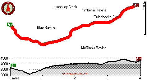
California hiking trails - Lafayette Ridge Trail, Northern Sierra Nevada, Sierra County

   
  Wilderness trails for trekking, and backpacking can be found all over California, and one of those is Lafayette Ridge Trail in Sierra County. California is a nice outdoors state. Rather far from Truckee-Grass Valley you discover Lafayette Ridge Trail, but it is a really good wilderness hiking trail. Sometimes this backcountry hiking trail gets really dry, so do check for current fire restrictions before you go if you plan to bring a stove or make a camp fire. This is a long backcountry hiking trail, so do pack enough food to last the whole trip. The total elevation
    difference for this backcountry trail is 1,583 feet which is an average number. Summer at Lafayette Ridge Trail arrives with high temperatures in the 80's. Once the sun is down it plunges down to the 50's. High temperatures through the wintertime are normally in the 40's with temperatures
at Lafayette Ridge Trail dipping down into the 20's through winter nights. And keep in mind that there could be temporary safety restrictions in place. There are numerous great outdoors trails in California, and each one has its own character. This is a two-ended backcountry trail with two trailheads, so backcountry hiking it one way is an option if you can arrange for a ride back. Being 8 miles long it's an average length great outdoors hiking trail. These trails here in the Northern Sierra Nevada are a very good way to see these summits. We all need to  
get out in nature once in a while, and Lafayette Ridge Trail in Sierra County, California is just what you need. Backcountry trekking in California is the great thing to do. This great outdoors hiking trail goes through some very different elevations, and that means that some parts of the great outdoors hiking trail could be very different from other parts of it. This is one of many backcountry hiking trails in the surrounding area. Lafayette Ridge Trail is a normal length trail having an average number of uphill miles which makes it a fine backcountry hiking trail for experienced hikers in glorious shape. All the water falling down from the sky makes Lafayette Ridge Trail a wet place; the wettest month of the year is frequently January, that's the one that rains the most while July is frequently the driest month. This walk shouldn't take more than 7 hours, but of course some folks walk a bit slower and some a bit faster.

Briefly about the general area:
Stay the night at Malakoff Diggins Shp, and some close by water includes Kimberley Creek. That right there is a load of cool stuff already but it goes on, the Northern Sierra Nevada has it all. You're sure to bump into some fine folks from Truckee-Grass Valley here. You'll need more than a day to discover everything Lafayette Ridge Trail has to offer, you can camp at Chute Hill Campground.
Walls Flat is a good site to check out; getting to Moore Flat Creek from Lafayette Ridge Trail is easy. Upper Woolsey Spring is an inspiring location to take a look at during your stay; there's whitewater on Yuba River - Middle Fork for all you adrenaline kick people.
You'll beyond doubt wish for more hours in a day to enjoy all the fun things in the Northern Sierra Nevada. Places like Tulpehocke Flat are nice to stop by, and you can run the rapids of Yuba River - South Fork. And if you're still looking for more outdoors cool things just keep reading. You might want to pay a visit to Kimberlin Ravine if you're here at Lafayette Ridge Trail, and a visit to Lafayette Ridge Trail wouldn't be complete without taking a look at Mobley Spring.

Location of Trailhead 1: Latitude 39.4421, Longitude -120.9114
- - Directions and Road Map

Location of Trailhead 2: Latitude 39.4504, Longitude -120.8567
- - Directions and Road Map


Trailhead 1 to Trailhead 2:
Total hiking length = 4 miles
Total climbing distance = 2.2 miles
Difficulty : Medium
Casual Hiking Pace: 4 hours
Fast Hiking Pace: 2 hours

Trailhead 2 to Trailhead 1:
Total hiking length = 4 miles
Total climbing distance = 1.4 miles
Difficulty : Medium
Casual Hiking Pace: 3.5 hours
Fast Hiking Pace: 2 hours
    Trailhead 1 back to Trailhead 1:
Total hiking length = 8 miles
Total climbing distance = 3.6 miles
Difficulty : Difficult
Casual Hiking Pace: 7 hours
Fast Hiking Pace: 4.5 hours

Trailhead 2 back to Trailhead 2:
Total hiking length = 8 miles
Total climbing distance = 3.6 miles
Difficulty : Difficult
Casual Hiking Pace: 7 hours
Fast Hiking Pace: 4.5 hours

Total elevation difference: 1583 feet


Deer Creek Inn, Nevada City
5 miles away
Deer Creek Inn is a 150 year old restored Queen Anne Victorian located in the historic Gold Rush town of Nevada City, California. The historic shopping and dining district on Broad Street is only foot...
  
Nevada City Inn, Nevada City
13 miles away
A home away from home! Comfortable, park-like setting, 2/3 of a mile to downtown Nevada City, 27 guest rooms inluding 7 cottages. We are now an all non smoking room hotel. We are a pet friendly hotel...
User input for Lafayette Ridge Trail, Northern Sierra Nevada, Sierra County, California:

Submit Input:
Your Name:
Write or Paste Input here:

Upload picture:      Review Guidelines


Outdoors Recreation Near Truckee-Grass Valley, California
Very comprehensive list of a variety of outdoors recreation in the vicinity of Truckee-Grass Valley, California, the metro area neareast to Lafayette Ridge Trail. Find info on campgrounds, hiking trails, ski resorts, lakes, beaches, parks, whitewater and more.

Current weather conditions at Lafayette Ridge Trail, Northern Sierra Nevada, Sierra County, California
WXPort

Local climate location: STRAWBERRY VALLEY 13 miles away

Piety Hill Cottages, Nevada City
14 miles away
9 Tastefully appointed BnB cottages in this parklike setting 1 acre with tree-shaded grassy courtyard...

Best Western Gold Country Inn, Grass Valley
15 miles away
Stay at this Grass Valley hotel in the heart of California's Gold Country. The Best Western Gold Country Inn is nestled amongst the pines of the Sierra Foothills off Highway 49 in California. The hot...

More Hotels and Campgrounds Near Lafayette Ridge Trail, Northern Sierra Nevada, Sierra County, California

OTHER_INFO
  Northern Sierra Nevada Campgrounds
Complete list of all the campgrounds in the Northern Sierra Nevada.

Northern Sierra Nevada Outdoors Info
Complete outdoors info for the Northern Sierra Nevada.

California Hiking Trails
Complete list of all hiking trails in California

Books about hiking trails in California
List of books available on Amazon.com about hiking trails in California.

California Outdoors Index
This is a very comprehensive index of outdoors activities in the great state of California.


TOPO
High quality water resistant topo map of Lafayette Ridge Trail, Northern Sierra Nevada, Sierra County, California.

OUTDOORS_GUIDE
These outdoors activities are available near Lafayette Ridge Trail.
 Trails Near Lafayette Ridge Trail:
Humbug Trail, Nevada County , 5 miles away,  4 hiking miles, 1041 feet elevation difference
Halls Ranch Trail, Sierra County , 7 miles away, 6.3 hiking miles, 2105 feet elevation difference
Bayes Cabin Road, Nevada County , 8 miles away,  3.4 hiking miles, 1568 feet elevation difference
South Yuba Trail, Nevada County , 8 miles away, 2.3 hiking miles, 929 feet elevation difference
Bedbug Smith Trail, Sierra County , 9 miles away,  6.2 hiking miles, 1927 feet elevation difference
Second Divide Trail, Sierra County , 12 miles away,  7.2 hiking miles, 1442 feet elevation difference
Third Divide Trail, Sierra County , 13 miles away, 2.5 hiking miles, 2062 feet elevation difference
 Camp Grounds Near Lafayette Ridge Trail:
Malakoff Diggins Shp, Nevada City, 3 miles away
Chute Hill Campground, Nevada County, 3 miles away
Shonter Hill Campground, Nevada County, 4 miles away
South Yuba Primitive Campground, Nevada County, 6 miles away
White Cloud - Tahoe National Forest, Nevada City, 7 miles away
 Whitewater Near Lafayette Ridge Trail:
Yuba River - Middle Fork, Sierra/ Nevada/ Yuba County County , 4 miles away, Class III-V - 22 miles long (Plumago Crossing to Route 49)
Yuba River - South Fork, Nevada County County , 5 miles away, Class IV - 14 miles long (Washington to Edwards Crossing)
Yuba River - North Fork, Sierra County County , 6 miles away, Class II-V - 4 miles long (Downieville to Goodyears Bar Bridge)
Yuba River - North Fork, Sierra County County , 7 miles away, Class IV - 8.5 miles long (Goodyears Bar Bridge to Highway 49 Bridge)
Pauley Creek, Sierra County County , 9 miles away, Class III-IV - 4 miles long (Second Divide Turnout to Downieville)
 National Parks Near Lafayette Ridge Trail:
Lassen Volcanic National Park, Mineral - CA , 68 miles away
 Hotels Near Lafayette Ridge Trail:
Deer Creek Inn, Nevada City , 5 miles away
Nevada City Inn, Nevada City , 13 miles away
Piety Hill Cottages, Nevada City , 14 miles away
Best Western Gold Country Inn, Grass Valley , 15 miles away
Holiday Lodge Grass Valley, Grass Valley , 16 miles away

Outdoors related information copyright © Stratus-Pikpuk, Inc. - Detailed hotel information copyright © Interactive Hotel Solutions