| |
|
| | Indians Trail is positioned a pretty long tour from Santa Barbara-Santa Maria-Goleta, but it sure is a a great backcountry hiking trail. Hiking here in California is so much fun. Every single California backpacking trail has its own unique beauty. Indians Trail is 15 miles long; it's considered a longer hike. You spend the whole hike in roughly the same elevation zone, so you get pretty much the same conditions along the whole backcountry trail. If you are in California during backcountry trekking season you have to go backcountry trekking. Indians Trail |
|
has a total elevation difference of 1,444 feet which is an average number. There are many tremendous backpacking trails in California, and Indians Trail in Santa Barbara County is one of them. Ok, you've been cooped up too long, time to get out in the outdoors a bit, and Indians
| | Trail in Santa Barbara County, California is just the site. Don’t forget to check for any current restrictions or closures before you go. This is one of a very small number of backpacking and hiking trails in this vicinity. The warmest time of the year at Indians Trail arrives with high temperatures in the 70's with nighttime lows in the 50's. The winter brings highs down to the 60's with winter lows in the 40's overnight here at Indians Trail. These hiking trails here in the Sierra Madre are a wonderful way to explore these summits. This region does | |
|
get very dry sometimes, so make sure you check current conditions and fire restrictions with local forest authorities before you head out. Now, this is roughly a 2.5-day backcountry hike, so make sure you've got all your overnight gear packed. This hiking trail is a hiking trail
of great length with an average amount of climbing distance which makes this backpacking and hiking trail magnificent for hard core backpackers looking for adventure. This is a two-ended great outdoors hiking trail with two trailheads, so backcountry trekking it one way is an option
if you can arrange for a ride back. Indians Trail is pretty arid generally; of all the months in a year January is the one with the most rain; July on the other hand is the driest. This is a long wilderness trail, so don't forget to pack enough supplies.
Briefly about the
general area: Sycamore Creek flows through this region. There's so much to do here at Indians Trail that you need to camp here for a while, Kerry Canyon Campground is a delightful site for that. Now, you may imagine that's lots but there's even more amusing stuff to do here
at Indians Trail. Porter Spring is an inspiring site to visit while you're here. You'll need more than a day to discover everything Indians Trail has to offer, you can camp at Brookshire Campground; if you're here, you could explore Sheep Camp Creek. A short trip to Johnson
Surprise Spring is always worthwhile, and there are some good whitewater spots on Cuyama River. Just can't get enough of the Sierra Madre. Pine Flat is a nice place, and nearby Gypsum Canyon is a great place to go.
|
|
Location of Trailhead 1: Latitude 35.0211, Longitude -120.1141 - - Directions and Road Map
Location of Trailhead 2: Latitude 34.9997, Longitude -120.061 - - Directions and Road Map

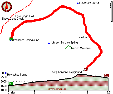
Trailhead 1 to Trailhead 2: Total hiking length = 7.5 miles Total climbing distance = 4.4 miles Difficulty : Difficult Casual Hiking Pace:
7.5 hours
Fast Hiking Pace:
4 hours
Trailhead 2 to Trailhead 1: Total hiking length = 7.5 miles Total climbing distance = 2.5 miles Difficulty : Difficult Casual Hiking Pace:
6 hours
Fast Hiking Pace:
3.5 hours
| | Trailhead 1 back to Trailhead 1: Total hiking length = 15 miles Total climbing distance = 6.9 miles Difficulty : Difficult Casual Hiking Pace:
2.5 days
Fast Hiking Pace:
9 hours
Trailhead 2 back to Trailhead 2: Total hiking length = 15 miles Total climbing distance = 6.9 miles Difficulty : Difficult Casual Hiking Pace:
2.5 days
Fast Hiking Pace:
9 hours
|
Total elevation difference: 1444 feet

Alamo Motel, Los Alamos
|
21 miles away
Welcome to Alamo Motel of Los Alamos, California. You will find clean, comfortable accomodations....
|
| |
Quality Inn & Suites, Santa Maria
|
23 miles away
Centrally located near Hancock College and Fairgrounds and across the street from the Marian Medical Center. Easy freeway access. Guest rooms with patios or balconies facing the swimming pool and cour...
|
|
User input for Indians Trail, Sierra Madre, Santa Barbara County, California:

Outdoors Recreation Near Santa Barbara-Santa Maria-Goleta, California Very comprehensive list of a variety of outdoors recreation in the vicinity of Santa Barbara-Santa Maria-Goleta, California, the metro area neareast to Indians Trail. Find info on campgrounds, hiking trails, ski resorts, lakes, beaches, parks, whitewater and more.
More Hotels and Campgrounds Near Indians Trail, Sierra Madre, Santa Barbara County, California
| |
|
| These outdoors activities are available near Indians Trail. |
| | Trails Near Indians Trail:
 |
Lake Ridge Trail, Santa Barbara
County
, 2 miles away, 4.5 hiking miles, 1833 feet elevation difference |
 |
Willow Spring Trail, Santa Barbara
County
, 4 miles away, 4.2 hiking miles, 1637 feet elevation difference |
|
| | Whitewater Near Indians Trail:
 |
Cuyama River, San Luis Obispo / Santa Barbara County
County
, 6 miles away, Class III-IV - 15 miles long (Highway 166 to Twitchell Reservoir) |
|
| | Hotels Near Indians Trail:
 |
Alamo Motel, Los Alamos
, 21 miles away |
 |
Quality Inn & Suites, Santa Maria
, 23 miles away |
 |
Americas Best Value Inn - Santa Maria, Santa Maria
, 24 miles away |
 |
Santa Ynez Inn, Santa Ynez
, 24 miles away |
 |
Candlewood Suites SANTA MARIA, Santa Maria
, 24 miles away |
|
|
|
 |
|