| |
|
| | Each backcountry hiking trail in California is different from the others. This part of California is always a bliss to stop by during backpacking season. There are many splendid backcountry hiking trails in California; one of them being Hunsucker Trail in El Dorado County. All the water falling down from the sky makes Hunsucker Trail a wet spot; January is the month that gets the most rain while July is commonly the driest month. Sometimes this wilderness hiking trail gets really dry, so make sure you check current conditions and fire restrictions with |
|
local forest authorities before you head out. Don’t forget to check for any current restrictions or closures before you go. This backcountry trek shouldn't take more than 3.5 hours, but you never know stuff could go wrong and you could get stuck so be prepared for that. The great
| | outdoors hiking trail stays roughly within the same elevation zone the whole time, so you won’t have to worry about different climate zones along your hike. There are so many backcountry hiking trails in this vicinity. Hunsucker Trail is on the short side with an average amount of climbing distance which makes this backcountry hiking trail magnificent for the average trekker looking for an enjoyable adventure. This is not a very long wilderness hiking trail but you should still bring some emergency supplies just in case something happens. Quite far from | |
|
Truckee-Grass Valley you bump into Hunsucker Trail, but it is a great backcountry trail. When was the last time you got out in nature a bit? Hunsucker Trail in El Dorado County, California is a great place for getting out. With its 3.8 miles of walking distance it's shorter than
many great outdoors hiking trails. Hiking trails like this one here in the Northern Sierra Nevada are the best way to enjoy these peaks. There are two trailheads to chose from, one in each end, so backcountry trekking it one way is an option if you can arrange for a ride back.
This wilderness hiking trail has a total elevation difference of 413 feet, and that is lower than average. Hiking here in California is so much fun. Throughout the days of summer here at Hunsucker Trail, high temperatures ordinarily get into the 90's, and through the night it cools
down to the 60's. The winter brings highs down to the 50's with winter lows in the 30's overnight here at Hunsucker Trail.
Briefly about the general area: These mountains rock, just check out all the cool stuff to do in the Northern Sierra Nevada. Stay the night at Sunset
Campground. A visit to Hunsucker Trail wouldn't be complete without taking a look at Cold Spring, and Yellow Jacket Campground is a good campground here.
|
|
Location of Trailhead 1: Latitude 38.9441, Longitude -120.4199 - - Directions and Road Map
Location of Trailhead 2: Latitude 38.9473, Longitude -120.4513 - - Directions and Road Map

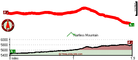
Trailhead 1 to Trailhead 2: Total hiking length = 1.9 miles Total climbing distance = 1.2 miles Difficulty : Medium Casual Hiking Pace:
2 hours
Fast Hiking Pace:
1 hours
Trailhead 2 to Trailhead 1: Total hiking length = 1.9 miles Total climbing distance = .4 miles Difficulty : Easy Casual Hiking Pace:
1.5 hours
Fast Hiking Pace:
1 hours
| | Trailhead 1 back to Trailhead 1: Total hiking length = 3.8 miles Total climbing distance = 1.6 miles Difficulty : Medium Casual Hiking Pace:
3.5 hours
Fast Hiking Pace:
2 hours
Trailhead 2 back to Trailhead 2: Total hiking length = 3.8 miles Total climbing distance = 1.6 miles Difficulty : Medium Casual Hiking Pace:
3.5 hours
Fast Hiking Pace:
2 hours
|
Total elevation difference: 413 feet

Best Western Stagecoach Inn, Pollock Pines
|
15 miles away
Amid tall pine trees of the high Sierra Mountains, Best Western Stagecoach Inn is located in the town of Pollock Pines, 'Nature's Wonderland', off of US 50 between Sacramento and South Lake Tahoe. Her...
|
| |
Westhaven Inn Pollock Pines, Pollock Pines
|
16 miles away
Outside of Sacramento and situated on Highway 50, The Westhaven Inn offers convenience to shopping, golfing, hiking, boating, skiing, and other various outdoor activities. Only minutes to Sierra at T...
|
|
User input for Hunsucker Trail, Northern Sierra Nevada, El Dorado County, California:

Outdoors Recreation Near Truckee-Grass Valley, California Very comprehensive list of a variety of outdoors recreation in the vicinity of Truckee-Grass Valley, California, the metro area neareast to Hunsucker Trail. Find info on campgrounds, hiking trails, ski resorts, lakes, beaches, parks, whitewater and more.
More Hotels and Campgrounds Near Hunsucker Trail, Northern Sierra Nevada, El Dorado County, California
| |
| |
 |
|
| These outdoors activities are available near Hunsucker Trail. |
| | Trails Near Hunsucker Trail:
 |
South Fork Trail, El Dorado
County
, 1 miles away, 6.8 hiking miles, 1919 feet elevation difference |
 |
Dry Lakes Trail, El Dorado
County
, 2 miles away, 4.3 hiking miles, 879 feet elevation difference |
 |
Rubicon Trail, El Dorado
County
, 3 miles away, 8.4 hiking miles, 2275 feet elevation difference |
 |
Grey Trail, Placer
County
, 3 miles away, 2.4 hiking miles, 2339 feet elevation difference |
 |
Ellicott Trail, El Dorado
County
, 4 miles away, 1.3 hiking miles, 1591 feet elevation difference |
 |
Hunters Trail, Placer
County
, 4 miles away, 5 hiking miles, 1957 feet elevation difference |
 |
Slide Point Trail, Placer
County
, 4 miles away, 1.2 hiking miles, 1512 feet elevation difference |
|
| | Hotels Near Hunsucker Trail:
 |
Best Western Stagecoach Inn, Pollock Pines
, 15 miles away |
 |
Westhaven Inn Pollock Pines, Pollock Pines
, 16 miles away |
 |
Squaw Valley Lodge, Squaw Valley
, 19 miles away |
 |
Village at Squaw Valley, Olympic Valley
, 19 miles away |
 |
Resort At Squaw Creek, Olympic Valley
, 21 miles away |
|
|
|
 |
|