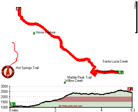
California hiking trails - Horse Pasture Trail, Santa Lucia Range, Monterey County

   
  California has plenty of splendid trails; one of them being Horse Pasture Trail in Monterey County. We all need to get out in nature once in a while, and Horse Pasture Trail in Monterey County, California is a really good place to spend some time. It's a long trip from Salinas to Horse Pasture Trail, but trekking along this backcountry hiking trail is very fun. Wilderness trails like this one here in the Santa Lucia Range are the best way to enjoy these highlands. This is a long backcountry trail, so make sure you bring plenty of supplies. Some parts
    of Horse Pasture Trail are much higher up than other parts of the great outdoors trail, and that means that some parts of the great outdoors trail could be very different from other parts of it. The total elevation difference for this trail is 1,737 feet which is about average.
Every California trail has something unique to offer. Of course, this is an overnight hike, 1.5 days normally, so better have big backpack to fit all the stuff you need. Horse Pasture Trail has two trailheads which means you have the option of backcountry backpacking it one way if you have someone to pick you up at the other end. With its 10.6 miles of walking distance; it's considered a longer backcountry walk. And keep in mind that there could be temporary safety restrictions in spot. Here in the splendid state of California backcountry backpacking  
is something that is always fun to do. This wilderness hiking trail is many miles long with an average amount of climbing distance which makes it a magnificent wilderness trail for experienced hikers in great shape. This backcountry trail sometimes gets very dry, so make sure you check current conditions and fire restrictions with local forest authorities before you head out. At Horse Pasture Trail throughout the months of summer highs are in the 70's, and during the night it cools down to the 50's. Daytime highs during the winter are in the 50's, and winter nights come with lows in the 40's to Horse Pasture Trail. The yearly rain here at Horse Pasture Trail is about average; during the month of January you get the most rain around here, and July on the other hand is the driest. Backcountry trekking in California is such a brilliant thing to do. This is a region covered with lots of wilderness trails.

Briefly about the general area:
There's whitewater on Arroyo Seco River for all you adrenaline junkies, and getting to Tassajara Creek from Horse Pasture Trail is uncomplicated. All the outdoors exciting things in the Santa Lucia Range will keep you coming back over and over. Deer Pasture is a lovely site any time of year, and some nearby water includes Willow Creek.
There's so much to do here at Horse Pasture Trail that you need to camp here for a while, China Camp is a brilliant place for that, and Strawberry Valley is another perfect spot to take a look at nearby. So much cool stuff to do at Horse Pasture Trail, so little time. You'll need more than a day to discover everything Horse Pasture Trail has to offer, you can camp at Rocky Creek Campground, and spots like Lost Valley are good to have a look at. There are some glorious whitewater spots on Arroyo Seco River, and while you're here you will meet lots of people from nearby Salinas.
Yeah, come up here to the Santa Lucia Range for a good time.

Location of Trailhead 1: Latitude 36.2182, Longitude -121.5021
- - Directions and Road Map

Location of Trailhead 2: Latitude 36.2474, Longitude -121.5489
- - Directions and Road Map


Trailhead 1 to Trailhead 2:
Total hiking length = 5.3 miles
Total climbing distance = 3.2 miles
Difficulty : Medium
Casual Hiking Pace: 5.5 hours
Fast Hiking Pace: 3 hours

Trailhead 2 to Trailhead 1:
Total hiking length = 5.3 miles
Total climbing distance = 1.5 miles
Difficulty : Easy
Casual Hiking Pace: 4 hours
Fast Hiking Pace: 2.5 hours
    Trailhead 1 back to Trailhead 1:
Total hiking length = 10.6 miles
Total climbing distance = 4.7 miles
Difficulty : Difficult
Casual Hiking Pace: 1.5 days
Fast Hiking Pace: 6 hours

Trailhead 2 back to Trailhead 2:
Total hiking length = 10.6 miles
Total climbing distance = 4.7 miles
Difficulty : Difficult
Casual Hiking Pace: 1.5 days
Fast Hiking Pace: 6 hours

Total elevation difference: 1737 feet


Ventana Inn Big Sur, Big Sur
9 miles away
Situated on 243 acres, 1,200 feet above the Pacific Ocean. The property is known for its serene setting, rustic yet luxurious sophistication and romantic allure. Features include 26 newly remodeled su...
  
Valley Harvest Inn, Soledad
18 miles away
Welcome to the Valley Harvest Inn, located in Soledad, CA, the heart of the Salinas Valley and Monterey County wine country. Close to Pinnacles National Monument, Mission Soledad, and Monterey Bay, th...
User input for Horse Pasture Trail, Santa Lucia Range, Monterey County, California:

Submit Input:
Your Name:
Write or Paste Input here:

Upload picture:      Review Guidelines


Outdoors Recreation Near Salinas, California
Very comprehensive list of a variety of outdoors recreation in the vicinity of Salinas, California, the metro area neareast to Horse Pasture Trail. Find info on campgrounds, hiking trails, ski resorts, lakes, beaches, parks, whitewater and more.

Current weather conditions at Horse Pasture Trail, Santa Lucia Range, Monterey County, California
WXPort

Local climate location: MONTEREY 7 miles away

Country Garden Inns, Carmel Valley
20 miles away
Nestled in the sunny Santa Lucia Mountains-just minutes from Carmel by the Sea California. Country Garden Inns offers two bed and breakfast inns with European hospitality. Both Hidden Valley Inn and A...

Bernardus Lodge, Carmel Valley
22 miles away
Nestled on verdant acres with stately pines and California oak trees, surrounded by a vineyard and the Santa Lucia mountains rising majestically in the background, Bernardus Lodge is a premier luxury ...

More Hotels and Campgrounds Near Horse Pasture Trail, Santa Lucia Range, Monterey County, California

OTHER_INFO
  Santa Lucia Range Campgrounds
Complete list of all the campgrounds in the Santa Lucia Range.

Santa Lucia Range Outdoors Info
Complete outdoors info for the Santa Lucia Range.

California Hiking Trails
Complete list of all hiking trails in California

Books about hiking trails in California
List of books available on Amazon.com about hiking trails in California.

California Outdoors Index
This is a very comprehensive index of outdoors activities in the great state of California.


TOPO
High quality water resistant topo map of Horse Pasture Trail, Santa Lucia Range, Monterey County, California.

OUTDOORS_GUIDE
These outdoors activities are available near Horse Pasture Trail.
 Trails Near Horse Pasture Trail:
Marble Peak Trail, Monterey County , 1 miles away, 1.6 hiking miles, 1188 feet elevation difference
Hot Springs Trail, Monterey County , 2 miles away,  4.4 hiking miles, 1545 feet elevation difference
Summit Trail, Monterey County , 5 miles away, 1.8 hiking miles, 1522 feet elevation difference
South Fork Trail, Monterey County , 6 miles away,  7.8 hiking miles, 1563 feet elevation difference
Church Creek Trail, Monterey County , 6 miles away,  3.8 hiking miles, 1279 feet elevation difference
North Coast Ridge Trail, Monterey County , 7 miles away, 9 hiking miles, 1385 feet elevation difference
Miller Canyon Trail, Monterey County , 8 miles away,  15.6 hiking miles, 2327 feet elevation difference
 Camp Grounds Near Horse Pasture Trail:
Rocky Creek Campground, Monterey County, 2 miles away
China Camp, Monterey County, 3 miles away
Hanging Valley Campground, Monterey County, 4 miles away
Lower Piney Creek Campground, Monterey County, 5 miles away
Piney Creek Campground, Monterey County, 5 miles away
 Whitewater Near Horse Pasture Trail:
Arroyo Seco River, Monterey County County , 3 miles away, Class IV(V) - 3 miles long (Willowcreek Bridge to Arroyo Seco Picnic Area)
Arroyo Seco River, Monterey County County , 9 miles away, Class III - 14.5 miles long (Arroyo Seco Picnic Area to Route G16 bridge)
Carmel River, Monterey County County , 16 miles away, Class II-III(IV) - 10 miles long (Los Padres Reservoir to Carmel Valley)
San Antonio, Monterey County County , 18 miles away, Class II - 10.7 miles long (Above and down to Mission San Antonio de Padua)
Big Sur River, Monterey County County , 18 miles away, Class II+ - 4 miles long (Pfeiffer Big Sur State Park to Motels)
 National Parks Near Horse Pasture Trail:
Pinnacles National Monument, Paicines - CA , 39 miles away
 Hotels Near Horse Pasture Trail:
Ventana Inn Big Sur, Big Sur , 9 miles away
Valley Harvest Inn, Soledad , 18 miles away
Country Garden Inns, Carmel Valley , 20 miles away
Bernardus Lodge, Carmel Valley , 22 miles away
Salinas-Days Inn Monterey, California, Salinas , 25 miles away
 Lakes Near Horse Pasture Trail
The Lakes, Monterey County , 3 miles away

Outdoors related information copyright © Stratus-Pikpuk, Inc. - Detailed hotel information copyright © Interactive Hotel Solutions