| |
|
| | When you're here in California hiking along one of its wilderness hiking trails is a good way to spend some time. This part of California is always a bliss to visit during backpacking season. Pleasant wilderness hiking trails in California are in abundance, and Hockett Meadows Trail is one of them, and it's in Tulare County. Throughout the long summer days, highs usually are in the 70's at Hockett Meadows Trail, and the overnight is slightly cooler of course, generally in the 50's. Daytime highs during the winter are in the 40's, and after the sun is |
|
down during the winter temperatures at Hockett Meadows Trail dip into the 20's. This backcountry trek should take you about 3 days, so make sure you've got all your overnight gear packed. There's not much difference in elevation along the great outdoors hiking trail, so you get
| | pretty much the same conditions along the whole great outdoors hiking trail. Sometimes this backcountry trail gets really dry, so don’t forget to check for any current fire restrictions before you go. You'll have got to go far from Visalia-Porterville to get to Hockett Meadows Trail, but when you spend some time trekking here you will feel like a whole new person. The total elevation difference for this great outdoors trail is 1,421 feet which is about average. Every California wilderness hiking trail has its own unique beauty. We all need to get out | |
|
in the outdoors once in a while, and Hockett Meadows Trail in Tulare County, California is a good spot to go. The amount of rainfall that falls at Hockett Meadows Trail is near the national average; most of the rain falls throughout January, and the driest month of the year is
July. There is only one trailhead, so in and out is the way to trek it normally. Keep in mind that this is a long backcountry trail, so make sure you bring plenty of supplies. Please follow all local rules about fires and camping. This backcountry trail is many miles long having
an average number of uphill miles which makes it a splendid great outdoors hiking trail for experienced hikers in splendid shape. This is one of a very small number of great outdoors hiking trails in this vicinity. The wonderful backcountry trails of the Southern Sierra Nevada
are a wonderful way to explore these summits. With its 20.2 miles of walking distance; it's considered a longer hike.
Briefly about the general area: If you don’t have a problem getting wet, you can always go whitewater paddling on Kaweah River - Middle Fork, and a journey
to Tufa Falls will fill your spirit with tremendous feelings. Don’t forget to explore Hockett Meadows while you're here at Hockett Meadows Trail; do pay a visit to Sequoia & Kings Canyon National Park since you're here at Hockett Meadows Trail. Now, you may feel that's lots
but there's even more amusing stuff to do here in the Southern Sierra Nevada. If you came to camp Atwell Mill Campground is a great location to do that; why not have a look at Bobcat Point also since you're here. Tar Gap is near Hockett Meadows Trail and is positively a good spot
to check out, and East Fork Grove is a great forest vicinity close by. Don't leave Hockett Meadows Trail without first paying a visit to Cold Spring; Deer Creek is near Hockett Meadows Trail and is always a joy to stop by. This place, Hockett Meadows Trail, it just has so much
outdoors cool stuff. Do set aside some time for Cahoon Meadow if you're here at Hockett Meadows Trail; whitewater paddling is good on Kaweah River. And if that's not sufficient there's lots more exciting stuff to do in the Southern Sierra Nevada. Deadwood Creek is one of the streams close by that might be worth stopping at, and camping at Cold Spring Campground is always a magnificent experience.
|
|
Location of Trailhead: Latitude 36.4489, Longitude -118.595 - - Directions and Road Map
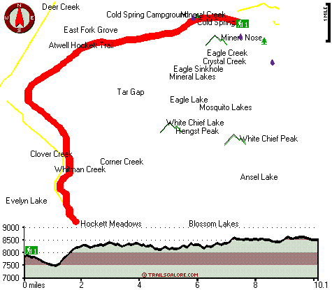
Total in and out hiking length = 20.2 miles
Total climbing distance = 9.4 miles
Difficulty : Difficult
Casual Hiking Pace:
3 days
Fast Hiking Pace:
2 days
Total elevation difference: 1421 feet

User input for Hockett Meadows Trail, Southern Sierra Nevada, Tulare County, California:

Outdoors Recreation Near Visalia-Porterville, California Very comprehensive list of a variety of outdoors recreation in the vicinity of Visalia-Porterville, California, the metro area neareast to Hockett Meadows Trail. Find info on campgrounds, hiking trails, ski resorts, lakes, beaches, parks, whitewater and more.
More Hotels and Campgrounds Near Hockett Meadows Trail, Southern Sierra Nevada, Tulare County, California
| |
| |
 |
|
| These outdoors activities are available near Hockett Meadows Trail. |
| | Trails Near Hockett Meadows Trail:
 |
Atwell Hockett Trail, Tulare
County
, 1 miles away, 17.2 hiking miles, 3021 feet elevation difference |
 |
Sawtooth Pass Trail, Tulare
County
, 7 miles away, 20.4 hiking miles, 4737 feet elevation difference |
 |
High Sierra Trail, Tulare
County
, 8 miles away, 76.8 hiking miles, 5185 feet elevation difference |
|
| | Whitewater Near Hockett Meadows Trail:
 |
Kaweah River - Middle Fork, Tulare County
County
, 11 miles away, Class V - 4.8 miles long (Hospital Rock) |
 |
Kaweah River, Tulare County
County
, 14 miles away, Class IV-V - 3 miles long (Above Gateway Bridge to Dinley Bridge) |
 |
Kaweah River, Tulare County
County
, 16 miles away, Class III-V - 3 miles long (Dinley Bridge to North Fork Bridge) |
 |
Kern River, Tulare County
County
, 17 miles away, Class II-V+ - 37 miles long (Junction Meadow to Forks of Kern) |
 |
Kaweah River - North Fork, Tulare County
County
, 18 miles away, Class IV-V - 6.4 miles long (Yucca Creek to Kaweah Bridge) |
|
| | Hotels Near Hockett Meadows Trail:
 |
Comfort Inn & Suites Sequoia Kings Canyon, Three Rivers
, 18 miles away |
 |
Americas Best Value Lazy J Ranch Three Rivers, Three Rivers
, 18 miles away |
 |
Best Western Porterville Inn, Porterville
, 33 miles away |
 |
Holiday Inn Express Hotel & Suites PORTERVILLE, Porterville
, 33 miles away |
 |
Super 8 Lindsay Olive Tree, Lindsay
, 33 miles away |
|
|
|
 |
|