| |
|
| | You can't spend all your time indoors you need to get out once in a while, and High Peaks Trail in San Benito County, California is a tremendous choice. Pretty far from Salinas you locate High Peaks Trail, but what a tremendous site for hiking it is. Going for a backcountry hike here in California is the great thing to do. Every single California hiking trail is different from the others. This is a long backpacking trail, so make sure you bring plenty of supplies. Brilliant hiking trails in California are in abundance, and High Peaks Trail in San Benito |
|
County is one of them. High Peaks Trail is a normal length backpacking trail with an average amount of climbing distance which makes this great outdoors trail perfect for hard core backpackers looking for adventure. This is one of a very small number of great outdoors trails in
| | this neighborhood. With its 7.6 miles of walking distance it's an average length hiking trail. High Peaks Trail gets very little rain; January is the wettest month with most rain, and July meanwhile is the driest month. High Peaks Trail has two trailheads, so backcountry hiking it one way is an option if you can arrange for a ride back. This backcountry walk shouldn't take more than 7 hours, but you never know stuff could go wrong and you could get stuck so be prepared for that. Summertime highs at High Peaks Trail generally tend to be in the 90's while | |
|
nighttime lows are generally in the 50's. The wintertime comes with highs in the 60's with temperatures at High Peaks Trail dipping down into the 30's all through winter nights. And keep in mind that there could be temporary safety restrictions in site. Backpacking here in California
is a must. At parts of the year this area sees very little rain, so make sure you check current conditions and fire restrictions with local forest authorities before you head out. Different parts of High Peaks Trail are at very different elevations, so keep in mind that you may
need to dress differently at different elevations. This hiking and backpacking trail has a total elevation difference of 1,535 feet, and that is about average.
Briefly about the general area: Don't leave High Peaks Trail without first paying a visit to Moses Spring;
camping is available at Chaparral Campground. Bear Gulch is a fine place to look at, and if you came for an overnight stay Chalone Annex Campground is a magnificent place to camp. Why not have a look at nearby North Fork Chalone Creek while you're here at High Peaks Trail,
and going to Pinnacles National Monument is just something you need to do if you haven't yet. If you're here at High Peaks Trail, you could check out West Fork Chalone Creek, and Bear Gulch Dam is an attention-grabbing thing to check out. You just can't picture the amount of outdoors amusing stuff the area next to High Peaks Trail has to offer. It's always splendid to have a look at Oak Tree Spring.
|
|
Location of Trailhead 1: Latitude 36.4772, Longitude -121.1847 - - Directions and Road Map
Location of Trailhead 2: Latitude 36.4814, Longitude -121.1809 - - Directions and Road Map

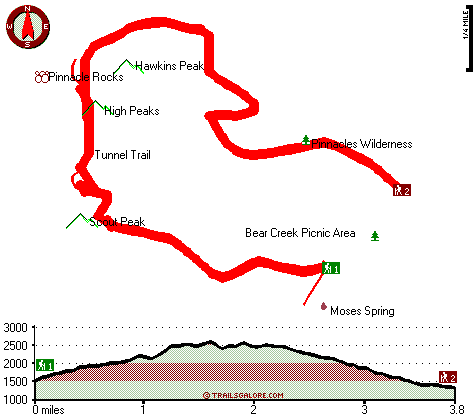
Trailhead 1 to Trailhead 2: Total hiking length = 3.8 miles Total climbing distance = 1.5 miles Difficulty : Medium Casual Hiking Pace:
3.5 hours
Fast Hiking Pace:
2 hours
Trailhead 2 to Trailhead 1: Total hiking length = 3.8 miles Total climbing distance = 2 miles Difficulty : Medium Casual Hiking Pace:
3.5 hours
Fast Hiking Pace:
2 hours
| | Trailhead 1 back to Trailhead 1: Total hiking length = 7.6 miles Total climbing distance = 3.5 miles Difficulty : Difficult Casual Hiking Pace:
7 hours
Fast Hiking Pace:
4.5 hours
Trailhead 2 back to Trailhead 2: Total hiking length = 7.6 miles Total climbing distance = 3.5 miles Difficulty : Difficult Casual Hiking Pace:
7 hours
Fast Hiking Pace:
4.5 hours
|
Total elevation difference: 1535 feet

Valley Harvest Inn, Soledad
|
9 miles away
Welcome to the Valley Harvest Inn, located in Soledad, CA, the heart of the Salinas Valley and Monterey County wine country. Close to Pinnacles National Monument, Mission Soledad, and Monterey Bay, th...
|
| |
King City Days Inn, King City
|
16 miles away
Welcome to Days Inn King City where we have 46 beautiful rooms for your convenience. We are conveniently located off Hwy 101 halfway between Los Angeles and San Francisco in the middle of wine country...
|
|
User input for High Peaks Trail, San Benito County, California:

Outdoors Recreation Near Salinas, California Very comprehensive list of a variety of outdoors recreation in the vicinity of Salinas, California, the metro area neareast to High Peaks Trail. Find info on campgrounds, hiking trails, ski resorts, lakes, beaches, parks, whitewater and more.
More Hotels and Campgrounds Near High Peaks Trail, San Benito County, California
| |
|
| These outdoors activities are available near High Peaks Trail. |
| | Trails Near High Peaks Trail:
 |
Tunnel Trail, San Benito
County
, 0 miles away, 3.6 hiking miles, 1385 feet elevation difference |
 |
Balconies Trail, San Benito
County
, 1 miles away, 1.4 hiking miles, 316 feet elevation difference |
 |
Chalone Peak Trail, Monterey
County
, 1 miles away, 2.7 hiking miles, 1720 feet elevation difference |
|
| | Hotels Near High Peaks Trail:
 |
Valley Harvest Inn, Soledad
, 9 miles away |
 |
King City Days Inn, King City
, 16 miles away |
 |
Quality Inn King City, King City
, 16 miles away |
 |
Best Western San Benito Inn, Hollister
, 26 miles away |
 |
Salinas-Days Inn Monterey, California, Salinas
, 31 miles away |
|
|
|
 |
|