| |
|
| | Every backpacking and hiking trail in California has its own character. In California you never run out of outdoors fun. Hennicksons Ridge Trail is a long trip away from Salinas, but it is a cool place to hike. Backcountry trekking here in the Santa Lucia Range is a very splendid way to see these highlands. If you happen to be in California, why not go backcountry trekking, it is always a fun thing to do. This is one of many hiking trails in the surrounding area. This region does get very dry sometimes, so make sure you check current conditions and fire |
|
restrictions with local forest authorities before you head out. This hiking and backpacking trail is a hiking and backpacking trail of splendid length with an average amount of climbing distance which makes this hiking trail good for hard core backpackers looking for adventure.
| | This wilderness trail goes through some very different elevations, and that means that some parts of the wilderness trail could be very different from other parts of it. Being 11.8 miles long; it's a long wilderness trail. Please follow all local rules about fires and camping. There are so many perfect backpacking and hiking trails for backcountry trekking in California; one of them being Hennicksons Ridge Trail in Monterey County. Throughout the summertime months, highs usually are in the 70's at Hennicksons Ridge Trail. When the night sets in temperatures | |
|
sink down into the 50's. Highs through the winter are mostly in the 50's; night lows at Hennicksons Ridge Trail through the winter mostly sink into the 40's. This hike should take you about 2 days, so better have big backpack to fit all the stuff you need. This is a backpacking
trail that is quite long, so do pack enough food to last the whole trip. Hennicksons Ridge Trail gets very little rainfall; of all the months in a year January is the one with the most rain while July is the month with the least amount of precipitation. When was the last time you
got out in nature a bit? Hennicksons Ridge Trail in Monterey County, California is a nice place to go. Hennicksons Ridge Trail has two trailheads which means you have the option of backcountry trekking it one way if you have someone to pick you up at the other end. The total elevation
difference for this trail is 2,356 feet which is about average.
Briefly about the general area: If you're visiting Hennicksons Ridge Trail from Salinas, you won't be the only one, and Rattlesnake Campground is a good local campground. There's no way somebody can
get bored here in the Santa Lucia Range. Hennicksons Ridge Trail is a great place to visit for more than one day, China Camp is a great place to camp nearby, and a short tour to Sulphur Spring is always worthwhile. A quick journey to Bruce Fork near Hennicksons Ridge Trail is a
nice idea, and a delightful place like Pine Valley here at Hennicksons Ridge Trail is too splendid to miss. A journey to Little Bear Trap is always fun, and get your heart beating on the splendid whitewater of Big Sur River. So many exciting things to do in the Santa Lucia
Range, not enough time. Whitewater paddling is not for everyone but if it's for you then we recommend Carmel River; Pine Falls is an inspiring place to explore during your stay. What a place this is for outdoors folks. If you're here at Hennicksons Ridge Trail, you could take a
look at Miller Fork Carmel River, and you should unquestionably dedicate some time to Bear Basin since you're here at Hennicksons Ridge Trail.
|
|
Location of Trailhead 1: Latitude 36.3895, Longitude -121.6521 - - Directions and Road Map
Location of Trailhead 2: Latitude 36.3576, Longitude -121.6059 - - Directions and Road Map

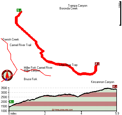
Trailhead 1 to Trailhead 2: Total hiking length = 5.9 miles Total climbing distance = 3.8 miles Difficulty : Medium Casual Hiking Pace:
6 hours
Fast Hiking Pace:
3.5 hours
Trailhead 2 to Trailhead 1: Total hiking length = 5.9 miles Total climbing distance = 1.5 miles Difficulty : Easy Casual Hiking Pace:
4.5 hours
Fast Hiking Pace:
2.5 hours
| | Trailhead 1 back to Trailhead 1: Total hiking length = 11.8 miles Total climbing distance = 5.3 miles Difficulty : Difficult Casual Hiking Pace:
2 days
Fast Hiking Pace:
7 hours
Trailhead 2 back to Trailhead 2: Total hiking length = 11.8 miles Total climbing distance = 5.3 miles Difficulty : Difficult Casual Hiking Pace:
2 days
Fast Hiking Pace:
7 hours
|
Total elevation difference: 2356 feet

Country Garden Inns, Carmel Valley
|
10 miles away
Nestled in the sunny Santa Lucia Mountains-just minutes from Carmel by the Sea California. Country Garden Inns offers two bed and breakfast inns with European hospitality. Both Hidden Valley Inn and A...
|
| |
Bernardus Lodge, Carmel Valley
|
11 miles away
Nestled on verdant acres with stately pines and California oak trees, surrounded by a vineyard and the Santa Lucia mountains rising majestically in the background, Bernardus Lodge is a premier luxury ...
|
|
User input for Hennicksons Ridge Trail, Santa Lucia Range, Monterey County, California:

Outdoors Recreation Near Salinas, California Very comprehensive list of a variety of outdoors recreation in the vicinity of Salinas, California, the metro area neareast to Hennicksons Ridge Trail. Find info on campgrounds, hiking trails, ski resorts, lakes, beaches, parks, whitewater and more.
|
Current weather conditions at Hennicksons Ridge Trail, Santa Lucia Range, Monterey County, California

Local climate location: MONTEREY 6 miles away

           
| |
Ventana Inn Big Sur, Big Sur
|
12 miles away
Situated on 243 acres, 1,200 feet above the Pacific Ocean. The property is known for its serene setting, rustic yet luxurious sophistication and romantic allure. Features include 26 newly remodeled su...
|
Post Ranch Inn, Big Sur
|
13 miles away
Unique architecture blends into its natural surroundings complemented with interior earth tones, high sweeping arches and skylights. In a spectacular setting, this 100 acre resort showcases the organi...
|
|
More Hotels and Campgrounds Near Hennicksons Ridge Trail, Santa Lucia Range, Monterey County, California
| |
| |
 |
|
| These outdoors activities are available near Hennicksons Ridge Trail. |
| | Trails Near Hennicksons Ridge Trail:
 |
Carmel River Trail, Monterey
County
, 2 miles away, 29.4 hiking miles, 3023 feet elevation difference |
 |
Miller Canyon Trail, Monterey
County
, 3 miles away, 15.6 hiking miles, 2327 feet elevation difference |
 |
Rattlesnake Creek Trail, Monterey
County
, 3 miles away, 7 hiking miles, 1350 feet elevation difference |
 |
Pine Ridge Trail, Monterey
County
, 4 miles away, 20.1 hiking miles, 4802 feet elevation difference |
 |
Church Creek Trail, Monterey
County
, 5 miles away, 3.8 hiking miles, 1279 feet elevation difference |
 |
San Clemente Trail, Monterey
County
, 6 miles away, 7 hiking miles, 714 feet elevation difference |
 |
Big Sur Trail, Monterey
County
, 8 miles away, 15.2 hiking miles, 1949 feet elevation difference |
|
| | Whitewater Near Hennicksons Ridge Trail:
 |
Carmel River, Monterey County
County
, 5 miles away, Class II-III(IV) - 10 miles long (Los Padres Reservoir to Carmel Valley) |
 |
Big Sur River, Monterey County
County
, 12 miles away, Class II+ - 4 miles long (Pfeiffer Big Sur State Park to Motels) |
 |
Arroyo Seco River, Monterey County
County
, 13 miles away, Class IV(V) - 3 miles long (Willowcreek Bridge to Arroyo Seco Picnic Area) |
 |
Little Sur River, Monterey County
County
, 14 miles away, Class III-IV - 7 miles long (Pico Blanco BSouth Carolina to Highway 1) |
 |
Arroyo Seco River, Monterey County
County
, 17 miles away, Class III - 14.5 miles long (Arroyo Seco Picnic Area to Route G16 bridge) |
|
| | Hotels Near Hennicksons Ridge Trail:
 |
Country Garden Inns, Carmel Valley
, 10 miles away |
 |
Bernardus Lodge, Carmel Valley
, 11 miles away |
 |
Ventana Inn Big Sur, Big Sur
, 12 miles away |
 |
Post Ranch Inn, Big Sur
, 13 miles away |
 |
Days Inn Salinas Airport, Salinas
, 17 miles away |
|
|
|
 |
|