California hiking trails - Heaton Flat Trail, San Gabriel Mountains, Los Angeles County

   
  Every single California hiking trail is worth backcountry hiking. Finally, hiking time is here again, and Heaton Flat Trail in Los Angeles County, California is a good location for getting out. Backpacking here in California is so much fun. The yearly rainfall here at Heaton Flat Trail is about average; the month with most of the rain is February, and July meanwhile is the driest month. Of course, this is an overnight backcountry trek, 2 days normally, so better have big backpack to fit all the stuff you need. The length of this backpacking trail is on
    the longer side with an average amount of climbing distance which makes it a good hiking trail for experienced hikers in splendid shape. Don’t forget to check for any current restrictions or closures before you go. Different parts of this hiking trail are at very different elevations,
so keep in mind that you may need to dress differently at different elevations. If you are in California during hiking season you have to go hiking. The total elevation difference for Heaton Flat Trail is 3,275 feet, and that is higher than average. This backcountry hiking trail sometimes gets very dry, so make sure you check current conditions and fire restrictions with local forest authorities before you head out. Heaton Flat Trail is a wilderness hiking trail quite far from Los Angeles-Long Beach-Santa Ana, but it is one of many fine wilderness hiking  
trails in this region. There are so many good hiking trails for backcountry hiking in California, and Heaton Flat Trail in Los Angeles County is one of them. Being 13.3 miles long; it's a long hiking trail. This is one of many hiking trails in the surrounding region. Throughout the summertime months here at Heaton Flat Trail, high temperatures commonly reach the 90's while overnight lows are mostly in the 50's. Daytime highs throughout the winter are in the 60's with winter lows in the 40's overnight here at Heaton Flat Trail. The backpacking trails of the San Gabriel Mountains are a glorious way to explore these hills. Heaton Flat Trail is quite long, so make sure you bring plenty of supplies.

Briefly about the general area:
If you go for the outdoors you'll go for it here in the San Gabriel Mountains. Don’t forget to take a look at Thompson Flat if you're here at Heaton Flat Trail, and you'll probably meet some folks from Los Angeles-Long Beach-Santa Ana here. A nice site to camp here at Heaton Flat Trail is Follows Camp, and do set aside some time for Heaton Flat while you're here at Heaton Flat Trail.
You'll really wish for more hours in a day to enjoy all the fun stuff in the San Gabriel Mountains. Camping at Eldoradoville Campground is always a pleasant experience, and some perfect nature is available in San Dimas Experimental Forest. If you crave a little side journey, try Laurel Gulch, and nearby you hit upon Newman Point.
You believe that's sufficient? Just getting warmed up. A spree to Forked Spruce Spring will fill your spirit with good feelings, and getting to Fish Fork from Heaton Flat Trail is painless. Don't leave Heaton Flat Trail without first paying a visit to Fallen Leaf Spring, and why not take a little tour to Iron Fork if you're here.

Location of Trailhead: Latitude 34.258, Longitude -117.748
- - Directions and Road Map

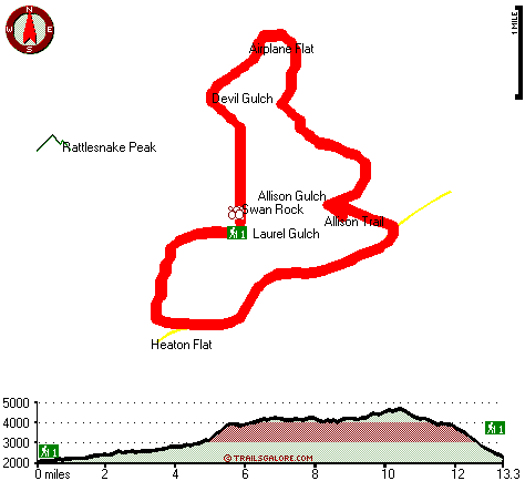
Total hiking length = 13.3 miles

Total climbing distance = 7 miles

Difficulty : Difficult

Casual Hiking Pace: 2 days

Fast Hiking Pace: 7 hours

Total elevation difference: 3275 feet


Rodeway Inn & Suites, Pomona
9 miles away
The Rodeway Inn hotel is conveniently located on historic Route 66 in a quiet area of Pomona, overlooking Mount Baldy. The hotel is within walking distance to restaurants and supermarkets. Amenities i...
  
Hotel Casa 425, Claremont
9 miles away
Claremont- California is known for its seven prestigious Claremont Colleges- tree-lined streets and historic buildings- located about 30 miles east of Los Angeles. In the summer of 2006- it will also ...
User input for Heaton Flat Trail, San Gabriel Mountains, Los Angeles County, California:

Submit Input:
Your Name:
Write or Paste Input here:

Upload picture:      Review Guidelines


Outdoors Recreation Near Los Angeles-Long Beach-Santa Ana, California
Very comprehensive list of a variety of outdoors recreation in the vicinity of Los Angeles-Long Beach-Santa Ana, California, the metro area neareast to Heaton Flat Trail. Find info on campgrounds, hiking trails, ski resorts, lakes, beaches, parks, whitewater and more.

Current weather conditions at Heaton Flat Trail, San Gabriel Mountains, Los Angeles County, California
WXPort

Local climate location: POMONA CAL POLY 20 miles away

Howard Johnson Express Inn, Claremont
10 miles away
The Howard Johnson Express Inn Claremont is located in the Inland Empire off I-10. Whether your travel is for business or pleasure, the Howard Johnson Express Inn is convenient to several locations in...

Claremont Lodge, Claremont
10 miles away
Whatever brings you to Southern California, business or family vacation, you will find the comfort and convenience of the Claremont Lodge perfectly suited in both price and location....

More Hotels and Campgrounds Near Heaton Flat Trail, San Gabriel Mountains, Los Angeles County, California

OTHER_INFO
  San Gabriel Mountains Campgrounds
Complete list of all the campgrounds in the San Gabriel Mountains.

San Gabriel Mountains Outdoors Info
Complete outdoors info for the San Gabriel Mountains.

California Hiking Trails
Complete list of all hiking trails in California

Books about hiking trails in California
List of books available on Amazon.com about hiking trails in California.

California Outdoors Index
This is a very comprehensive index of outdoors activities in the great state of California.


TOPO
High quality water resistant topo map of Heaton Flat Trail, San Gabriel Mountains, Los Angeles County, California.

OUTDOORS_GUIDE
These outdoors activities are available near Heaton Flat Trail.
 Trails Near Heaton Flat Trail:
Allison Trail, Los Angeles County , 1 miles away,  17 hiking miles, 5495 feet elevation difference
Fern Canyon Trail, Los Angeles County , 4 miles away,  13 hiking miles, 455 feet elevation difference
Baldy Trail, Los Angeles County , 6 miles away, 7.5 hiking miles, 7055 feet elevation difference
Dawson Peak Trail, Los Angeles County , 7 miles away,  18 hiking miles, 3488 feet elevation difference
Pacific Crest Trail - section 7, County , 7 miles away, 52.1 hiking miles, 7647 feet elevation difference
West Fork Trail, San Bernardino County , 8 miles away,  3.2 hiking miles, 927 feet elevation difference
Ontario Peak Trail, San Bernardino County , 9 miles away,  5 hiking miles, 1159 feet elevation difference
 Camp Grounds Near Heaton Flat Trail:
Eldoradoville Campground, Los Angeles County, 3 miles away
Follows Camp, Azusa, 5 miles away
Cabin Flat Campground, Los Angeles County, 6 miles away
Crystal Lake - Angeles National Forest, Mt Baldy, 7 miles away
Crystal Lake Deer Flats Group - Angeles National Forest, Mt Baldy, 7 miles away
 National Parks Near Heaton Flat Trail:
Mojave National Preserve, Barstow - CA , 60 miles away
 Hotels Near Heaton Flat Trail:
Rodeway Inn & Suites, Pomona , 9 miles away
Hotel Casa 425, Claremont , 9 miles away
Howard Johnson Express Inn, Claremont , 10 miles away
Claremont Lodge, Claremont , 10 miles away
Hotel Claremont, Claremont , 10 miles away
 Lakes Near Heaton Flat Trail
San Dimas Reservoir, Los Angeles County , 6 miles away
Big Dalton Reservoir, Los Angeles County , 7 miles away

Outdoors related information copyright © Stratus-Pikpuk, Inc. - Detailed hotel information copyright © Interactive Hotel Solutions