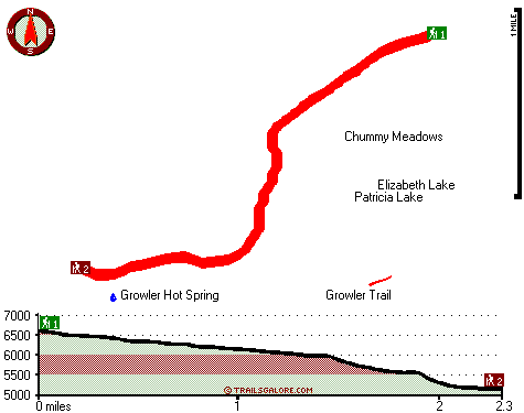
California hiking trails - Hanna Trail, Southern Cascade Range, Tehama County

   
  California has so much to offer nature lovers. Every single California backcountry hiking trail is worth backcountry trekking. Hanna Trail is a long drive away from Red Bluff, but it is a magnificent hiking trail. Even though this is not a very long backpacking and hiking trail it's always fine to bring some emergency supplies, you never know what could happen. Trekking here in the Southern Cascade Range is a perfect way to explore these hills. Here in California backcountry trekking is the good thing to do. Don’t forget to check for any current restrictions
    or closures before you go. Summer at Hanna Trail comes with high temperatures in the 90's. Once the sun is down it drops down to the 60's. The winter brings highs down to the 50's while the cold winter nights at Hanna Trail are in the 30's. Hanna Trail is a normal length great
outdoors trail with an average amount of climbing distance which makes this trail delightful for the average hiker looking for a fun adventure. A lot of precipitation falls at Hanna Trail; all through the month of January you get the most rain around here while July is the month with the least amount of precipitation. Hitting the hiking trails is always a fun thing to do, and Hanna Trail in Tehama County, California is nature at its best. Backpacking trails are good and plentiful in California, and Hanna Trail in Tehama County is one of them. Hanna Trail  
has two trailheads, so backcountry hiking it one way is an option if you can arrange for a ride back. Different parts of this backcountry trail are at very different elevations which of course means you need to be prepared for different conditions on different parts of the backcountry trail. The time needed for this backcountry walk is roughly 4 hours, but you never know stuff could go wrong and you could get stuck so be prepared for that. There are so many trails in this area. This vicinity does get very dry sometimes, so make sure you check current conditions and fire restrictions with local forest authorities before you head out. With its 4.6 miles of walking distance it's a mid length walk. The total elevation difference for this wilderness hiking trail is 1,799 feet which is an average number.

Briefly about the general area:
You'll need more than a day to look at everything Hanna Trail has to offer, you can camp at Kings Creek Campground, and Little Hot Springs Valley is a good place to stop at. You just can't picture the amount of outdoors cool things the Southern Cascade Range has to offer.
Whohoo, so much enjoyable stuff in one place! The Southern Cascade Range is peerless! East Sulphur Creek flows through this vicinity; Morgan Hot Spring is a good local attraction. If you're here at Hanna Trail, you could have a look at Canyon Creek, and Lassen Volcanic National Park is a perfect place nearby. Spencer Meadow is a tremendous location here at Hanna Trail, and you can stay the night at Bluff Falls Campground.
Having a good time at Hanna Trail is trouble-free. Chummy Meadows is right here at Hanna Trail, and do put some time aside to spend at Growler Hot Spring while you're here at Hanna Trail.

Location of Trailhead 1: Latitude 40.4147, Longitude -121.4825
- - Directions and Road Map

Location of Trailhead 2: Latitude 40.3969, Longitude -121.5096
- - Directions and Road Map


Trailhead 1 to Trailhead 2:
Total hiking length = 2.3 miles
Total climbing distance = 0 miles
Difficulty : Easy
Casual Hiking Pace: 1.5 hours
Fast Hiking Pace: .5 hours

Trailhead 2 to Trailhead 1:
Total hiking length = 2.3 miles
Total climbing distance = 1.6 miles
Difficulty : Difficult
Casual Hiking Pace: 2.5 hours
Fast Hiking Pace: 1.5 hours
    Trailhead 1 back to Trailhead 1:
Total hiking length = 4.6 miles
Total climbing distance = 1.6 miles
Difficulty : Medium
Casual Hiking Pace: 4 hours
Fast Hiking Pace: 2.5 hours

Trailhead 2 back to Trailhead 2:
Total hiking length = 4.6 miles
Total climbing distance = 1.6 miles
Difficulty : Medium
Casual Hiking Pace: 4 hours
Fast Hiking Pace: 2.5 hours

Total elevation difference: 1799 feet


Bailey Creek Cottages, Chester
16 miles away
Bailey Creek Cottages are located on the Public 18-Hole Bailey Creek Golf Course on the peninsula of Lake Almanor near Chester, California. Stay and play packages are available all through the golf se...
  
Best Western Rose Quartz Inn, Chester
19 miles away
This Chester, California hotel is the perfect mountain get-away, offering a variety of amenities including an outdoor spa, recreation area, complimentary deluxe continental breakfast each morning. N...
User input for Hanna Trail, Southern Cascade Range, Tehama County, California:

Submit Input:
Your Name:
Write or Paste Input here:

Upload picture:      Review Guidelines


Outdoors Recreation Near Red Bluff, California
Very comprehensive list of a variety of outdoors recreation in the vicinity of Red Bluff, California, the metro area neareast to Hanna Trail. Find info on campgrounds, hiking trails, ski resorts, lakes, beaches, parks, whitewater and more.

Current weather conditions at Hanna Trail, Southern Cascade Range, Tehama County, California
WXPort

Local climate location: VOLTA POWER HOUSE 6 miles away

Comfort Inn Central, Paradise
36 miles away
Quite country location, beautifully appointed guest rooms, excellent customer service, award winning hotel. Easy commute to Chico and Ca State University. Numerous local antique shops, Plenty of activ...

Paradise Inn, Paradise
36 miles away
Welcome to the Paradise Inn. Nestled amongst the beautiful tall pines you will discover one of the oldest, and most desirable places for lodging in the quaint little town of Paradise, Ca. As you enter...

More Hotels and Campgrounds Near Hanna Trail, Southern Cascade Range, Tehama County, California

OTHER_INFO
  Southern Cascade Range Campgrounds
Complete list of all the campgrounds in the Southern Cascade Range.

Southern Cascade Range Outdoors Info
Complete outdoors info for the Southern Cascade Range.

California Hiking Trails
Complete list of all hiking trails in California

Books about hiking trails in California
List of books available on Amazon.com about hiking trails in California.

California Outdoors Index
This is a very comprehensive index of outdoors activities in the great state of California.


TOPO
High quality water resistant topo map of Hanna Trail, Southern Cascade Range, Tehama County, California.

OUTDOORS_GUIDE
These outdoors activities are available near Hanna Trail.
 Trails Near Hanna Trail:
Growler Trail, Tehama County , 1 miles away,  2.6 hiking miles, 1156 feet elevation difference
Childs Meadows Trail, Tehama County , 1 miles away,  6.4 hiking miles, 1369 feet elevation difference
Chaos Crags Trail, Shasta County , 7 miles away,  3.4 hiking miles, 929 feet elevation difference
Heart Lake Twin Meadows Trail, Tehama County , 9 miles away,  7.2 hiking miles, 1384 feet elevation difference
Lassen Trail, Tehama County , 9 miles away, 2.2 hiking miles, 224 feet elevation difference
 Camp Grounds Near Hanna Trail:
Bluff Falls Campground, Tehama County, 3 miles away
Kings Creek Campground, Shasta County, 3 miles away
Hole in the Ground Campground, Tehama County, 7 miles away
Bear Wallow Campground, Tehama County, 7 miles away
Warner Valley Campground, Plumas County, 7 miles away
 National Parks Near Hanna Trail:
Lassen Volcanic National Park, Mineral - CA , 5 miles away
 Hotels Near Hanna Trail:
Bailey Creek Cottages, Chester , 16 miles away
Best Western Rose Quartz Inn, Chester , 19 miles away
Comfort Inn Central, Paradise , 36 miles away
Paradise Inn, Paradise , 36 miles away
Best Western Heritage Inn - Chico, Chico , 42 miles away
 Lakes Near Hanna Trail
Forest Lake, Tehama County , 4 miles away

Outdoors related information copyright © Stratus-Pikpuk, Inc. - Detailed hotel information copyright © Interactive Hotel Solutions