| |
|
| | Hiking in California never gets boring. California has lots of outdoors endeavors. It's a long journey from Red Bluff to Growler Trail, but what a tremendous place for trekking it is. All the water falling down from the sky makes Growler Trail a wet place; January is the wettest month with most rain; the driest of the months is July. Don’t forget to check for any current restrictions or closures before you go. There's not much difference in elevation along Growler Trail, so you won’t have to worry about different climate zones along your backcountry trek. |
|
High temperatures at Growler Trail throughout the summertime are in the 90's, and throughout summer nights temperatures are in the 60's. The cold days of the wintertime come with highs in the 50's, and night lows in the 30's for Growler Trail. Growler Trail is on the short side
| | having an average number of uphill miles which makes it a great great outdoors hiking trail for the average person looking for a great adventure. Wilderness hiking trails for trekking, and backpacking can be found all over California, and Growler Trail in Tehama County is one of them. This is one of many great outdoors hiking trails in the surrounding vicinity. Growler Trail has a total elevation difference of 1,156 feet which is about average. At parts of the year this vicinity sees very little rain, so make sure you check current conditions and fire | |
|
restrictions with local forest authorities before you head out. Growler Trail is not that long but you should still bring some emergency supplies just in case something happens. When was the last time you got out in the outdoors a bit? Growler Trail in Tehama County, California
is a really magnificent place to spend some time. You should count on this backcountry trek taking about 2 hours, but you never know stuff could go wrong and you could get stuck so be prepared for that. Growler Trail has only one trailhead, so you're looking at an in and out backcountry
walk. There are numerous wilderness trails in California, and each one has its own unique beauty. With its 2.6 miles of walking distance it's a shorter type backcountry trek. Great outdoors hiking trails like this one here in the Southern Cascade Range are a very great way to see
these mountains.
Briefly about the general area: Camping at Bluff Falls Campground is always a great experience, and a short visit to Growler Hot Spring is always worthwhile. Canyon Creek is a tremendous local stream; Morgan Hot Spring is an inspiring place to go to
while here. So much enjoyable stuff in the Southern Cascade Range, just amazing. Camping is available at Kings Creek Campground; sites like Chummy Meadows are brilliant to pop by. Visiting Lassen Volcanic National Park is just something you need to do if you haven't yet.
|
|
Location of Trailhead: Latitude 40.3944, Longitude -121.5051 - - Directions and Road Map
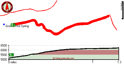
Total in and out hiking length = 2.6 miles
Total climbing distance = .9 miles
Difficulty : Medium
Casual Hiking Pace:
2 hours
Fast Hiking Pace:
1.5 hours
Total elevation difference: 1156 feet

Bailey Creek Cottages, Chester
|
15 miles away
Bailey Creek Cottages are located on the Public 18-Hole Bailey Creek Golf Course on the peninsula of Lake Almanor near Chester, California. Stay and play packages are available all through the golf se...
|
| |
Best Western Rose Quartz Inn, Chester
|
18 miles away
This Chester, California hotel is the perfect mountain get-away, offering a variety of amenities including an outdoor spa, recreation area, complimentary deluxe continental breakfast each morning. N...
|
|
User input for Growler Trail, Southern Cascade Range, Tehama County, California:

Outdoors Recreation Near Red Bluff, California Very comprehensive list of a variety of outdoors recreation in the vicinity of Red Bluff, California, the metro area neareast to Growler Trail. Find info on campgrounds, hiking trails, ski resorts, lakes, beaches, parks, whitewater and more.
|
Current weather conditions at Growler Trail, Southern Cascade Range, Tehama County, California

Local climate location: VOLTA POWER HOUSE 6 miles away

           
| |
Comfort Inn Central, Paradise
|
35 miles away
Quite country location, beautifully appointed guest rooms, excellent customer service, award winning hotel. Easy commute to Chico and Ca State University. Numerous local antique shops, Plenty of activ...
|
Paradise Inn, Paradise
|
35 miles away
Welcome to the Paradise Inn. Nestled amongst the beautiful tall pines you will discover one of the oldest, and most desirable places for lodging in the quaint little town of Paradise, Ca. As you enter...
|
|
More Hotels and Campgrounds Near Growler Trail, Southern Cascade Range, Tehama County, California
| |
|
| These outdoors activities are available near Growler Trail. |
| | Trails Near Growler Trail:
 |
Hanna Trail, Tehama
County
, 1 miles away, 2.3 hiking miles, 1799 feet elevation difference |
 |
Childs Meadows Trail, Tehama
County
, 1 miles away, 6.4 hiking miles, 1369 feet elevation difference |
 |
Chaos Crags Trail, Shasta
County
, 8 miles away, 3.4 hiking miles, 929 feet elevation difference |
 |
Lassen Trail, Tehama
County
, 9 miles away, 2.2 hiking miles, 224 feet elevation difference |
 |
Heart Lake Twin Meadows Trail, Tehama
County
, 9 miles away, 7.2 hiking miles, 1384 feet elevation difference |
 |
Carter Meadow Trail, Tehama
County
, 11 miles away, 3.6 hiking miles, 1153 feet elevation difference |
|
| | Hotels Near Growler Trail:
 |
Bailey Creek Cottages, Chester
, 15 miles away |
 |
Best Western Rose Quartz Inn, Chester
, 18 miles away |
 |
Comfort Inn Central, Paradise
, 35 miles away |
 |
Paradise Inn, Paradise
, 35 miles away |
 |
Oxford Suites Chico, Chico
, 41 miles away |
|
|
|
 |
|