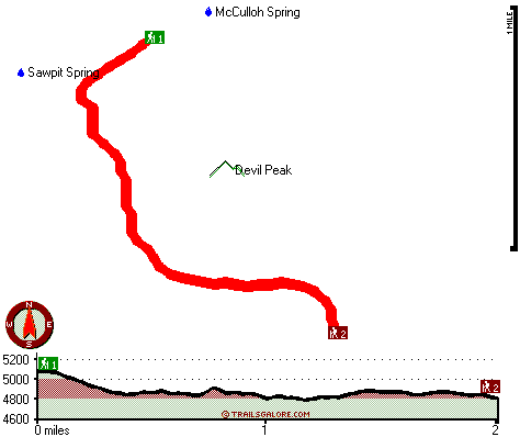
| |
|
| | There are many perfect backcountry hiking trails in California; one of those is Grizzly Canyon Trail in Placer County. It's a lengthy tour from Truckee-Grass Valley to Grizzly Canyon Trail, but what a perfect location for hiking it is. Here in California trekking is so much fun. This is just one of a large number of hiking trails in this neighborhood. At parts of the year this area sees very little rain, so don’t forget to check for any current fire restrictions before you go. Every single California backcountry hiking trail is different from the others. |
|
This wilderness hiking trail is a mid length wilderness hiking trail with an average amount of climbing distance which makes it an outstanding hiking trail for the average person looking for an outstanding adventure. The wilderness hiking trails of the Northern Sierra Nevada are
| | the best way to enjoy these mountains. For the duration of the warmest time of the year highs here at Grizzly Canyon Trail reach the 90's. When the night sets in temperatures sink down into the 60's. Highs during the wintertime are usually in the 50's, and after the sun is down during the wintertime temperatures at Grizzly Canyon Trail sink into the 30's. The time needed for this backcountry walk is roughly 3.5 hours, but you never know stuff could go wrong and you could get stuck so be prepared for that. You spend the whole trek in roughly the same elevation | |
|
zone, so you get pretty much the same conditions along the whole backpacking and hiking trail. Grizzly Canyon Trail is 4 miles long it's a mid length trek. This is a two-ended hiking trail with two trailheads, so trekking it one way is an option if you can arrange for a ride back.
Grizzly Canyon Trail is a quite wet site usually with a lot of rainfall; of all the months in a year January is the one with the most rain, and the driest of the months is July. Hiking in California is such an excellent thing to do. Time to get out, and breathe some fresh air,
and Grizzly Canyon Trail in Placer County, California is a perfect selection. Grizzly Canyon Trail has a total elevation difference of 381 feet which is lower than average. This is not a very long great outdoors trail but it's always glorious to bring some emergency supplies, you
never know what could happen. Please follow all local rules about fires and camping.
Briefly about the general area: A good spot to camp here at Grizzly Canyon Trail is Vista Overflow Campground; a wonderful site close by is Little Wallace Canyon. Sawpit Spring is a
picturesque location to check out while you're at Grizzly Canyon Trail, and American River - South Fork has a nice whitewater paddling spot nearby. Man, is there lots of amusing things to do in the Northern Sierra Nevada. Camping is available at Big Tree Grove Campground, and
in case you don’t have a problem getting covered with water, you can always go whitewater paddling on Rubicon River. A short visit to McCulloh Spring is always worthwhile.
|
|
Location of Trailhead 1: Latitude 38.9667, Longitude -120.5513 - - Directions and Road Map
Location of Trailhead 2: Latitude 38.9492, Longitude -120.5405 - - Directions and Road Map

Trailhead 1 to Trailhead 2: Total hiking length = 2 miles Total climbing distance = .7 miles Difficulty : Medium Casual Hiking Pace:
1.5 hours
Fast Hiking Pace:
1 hours
Trailhead 2 to Trailhead 1: Total hiking length = 2 miles Total climbing distance = 1.1 miles Difficulty : Medium Casual Hiking Pace:
2 hours
Fast Hiking Pace:
1 hours
| | Trailhead 1 back to Trailhead 1: Total hiking length = 4 miles Total climbing distance = 1.8 miles Difficulty : Medium Casual Hiking Pace:
3.5 hours
Fast Hiking Pace:
2.5 hours
Trailhead 2 back to Trailhead 2: Total hiking length = 4 miles Total climbing distance = 1.8 miles Difficulty : Medium Casual Hiking Pace:
3.5 hours
Fast Hiking Pace:
2.5 hours
|
Total elevation difference: 381 feet

Best Western Stagecoach Inn, Pollock Pines
|
11 miles away
Amid tall pine trees of the high Sierra Mountains, Best Western Stagecoach Inn is located in the town of Pollock Pines, 'Nature's Wonderland', off of US 50 between Sacramento and South Lake Tahoe. Her...
|
| |
Westhaven Inn Pollock Pines, Pollock Pines
|
11 miles away
Outside of Sacramento and situated on Highway 50, The Westhaven Inn offers convenience to shopping, golfing, hiking, boating, skiing, and other various outdoor activities. Only minutes to Sierra at T...
|
|
User input for Grizzly Canyon Trail, Northern Sierra Nevada, Placer County, California:

Outdoors Recreation Near Truckee-Grass Valley, California Very comprehensive list of a variety of outdoors recreation in the vicinity of Truckee-Grass Valley, California, the metro area neareast to Grizzly Canyon Trail. Find info on campgrounds, hiking trails, ski resorts, lakes, beaches, parks, whitewater and more.
More Hotels and Campgrounds Near Grizzly Canyon Trail, Northern Sierra Nevada, Placer County, California
| |
| |
 |
|
| These outdoors activities are available near Grizzly Canyon Trail. |
| | Trails Near Grizzly Canyon Trail:
 |
Pigeon Roost Trail, Placer
County
, 2 miles away, 1.4 hiking miles, 763 feet elevation difference |
 |
Belix Trail, Placer
County
, 3 miles away, 6.9 hiking miles, 1141 feet elevation difference |
 |
Slide Point Trail, Placer
County
, 4 miles away, 1.2 hiking miles, 1512 feet elevation difference |
 |
Ellicott Trail, El Dorado
County
, 5 miles away, 1.3 hiking miles, 1591 feet elevation difference |
 |
Grey Trail, Placer
County
, 6 miles away, 2.4 hiking miles, 2339 feet elevation difference |
 |
Rubicon Trail, El Dorado
County
, 8 miles away, 8.4 hiking miles, 2275 feet elevation difference |
 |
Nevada Point Trail, El Dorado
County
, 9 miles away, 5.3 hiking miles, 2771 feet elevation difference |
|
| | Whitewater Near Grizzly Canyon Trail:
 |
Rubicon River, Placer/ El Dorado County
County
, 2 miles away, Class V - 20.3 miles long (Ellicott Bridge to Ralston Afterbay) |
 |
American River - South Fork, El Dorado County
County
, 9 miles away, Class IV-V - 9.4 miles long (Peavine Ridge Road to Forebay Road) |
 |
American River - South Fork, El Dorado County
County
, 12 miles away, Class III-IV - 3.5 miles long (Riverton to Peavine Ridge Road) |
|
| | Hotels Near Grizzly Canyon Trail:
 |
Best Western Stagecoach Inn, Pollock Pines
, 11 miles away |
 |
Westhaven Inn Pollock Pines, Pollock Pines
, 11 miles away |
 |
NATIONAL 9 INN, Placerville
, 19 miles away |
 |
Albert Shafsky House Bed And Breakfast, Placerville
, 19 miles away |
 |
Historic Cary House Hotel, Placerville
, 21 miles away |
|
|
|
 |
|